10 pm Advisory — Henri Continues Moving Northward Toward Long Island & Southern New England
SUMMARY OF 1000 PM CDT…0300 UTC…INFORMATION
———————————————–
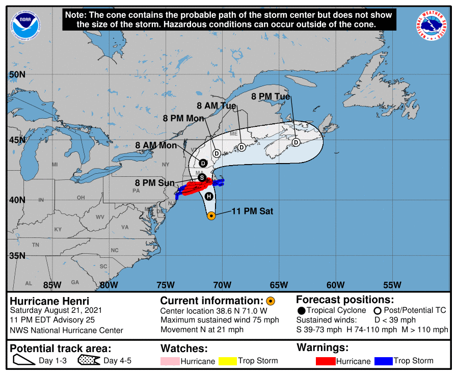
LOCATION…38.6N 71.0W
ABOUT 180 MI…290 KM SSE OF MONTAUK POINT NEW YORK
ABOUT 220 MI…355 KM S OF PROVIDENCE RHODE ISLAND
MAXIMUM SUSTAINED WINDS…75 MPH…120 KM/H
PRESENT MOVEMENT…N OR 355 DEGREES AT 21 MPH…33 KM/H
MINIMUM CENTRAL PRESSURE…987 MB…29.15 INCHES
WATCHES AND WARNINGS
——————–
A Storm Surge Warning is in effect for…
* South shore of Long Island from Mastic Beach to Montauk Point New York
* North shore of Long Island from Montauk Point to Flushing New York
* Flushing New York to Chatham Massachusetts
* Nantucket, Martha’s Vineyard, and Block Island
A Storm Surge Watch is in effect for…
* East Rockaway Inlet to Mastic New York
* North of Chatham Massachusetts to Sagamore Beach Massachusetts
* Cape Cod Bay
A Hurricane Warning is in effect for…
* South shore of Long Island from Fire Island Inlet to Montauk Point
* North shore of Long Island from Port Jefferson Harbor to Montauk Point
* New Haven Connecticut to west of Westport Massachusetts
* Block Island
A Tropical Storm Warning is in effect for…
* Port Jefferson Harbor to west of New Haven Connecticut
* South shore of Long Island from west of Fire Island Inlet to East Rockaway Inlet
* Westport Massachusetts to Chatham Massachusetts, including Martha’s Vineyard and Nantucket
* Coastal New York and New Jersey west of East Rockaway Inlet to Manasquan Inlet, including New York City
FORECAST DISCUSSION
——————–
The convective pattern associated with Henri is less ragged than it was 6 h ago, as the convection has increased near the center and a NOAA Hurricane Hunter aircraft reported a 25 n mi wide eye has formed However, the hurricane has not yet strengthened significantly, as the maximum winds remain about 65 kt in the southeastern eyewall and the central pressure is near 987 mb.
Henri has moved a little to the right of the previous track at 18-20 kt during the past several hours. However, the cyclone now seems to be moving northward with an initial motion of 355/18 kt. There is no change to the forecast track philosophy. A cut-off low located over the central Appalachians and a ridge building to the east and northeast of Henri should cause the storm to move generally northward tonight. A turn toward the north-northwest and a slower forward speed are expected on Sunday, which should bring the center near or over southern New England or Long Island between 18-24 h. With the more eastward initial position, the forecast track is shifted a bit to the east of the previous forecast. However, there is still some uncertainty of the landfall point, as several of the guidance models are to the left of the official forecast. After landfall, Henri should slow its forward speed and turn eastward as it become steered by the mid-latitude westerlies. Users are reminded to not focus on the exact forecast track, as the average 24-hour track uncertainty is around 40 miles and impacts will extend well away from the center.
Henri is almost out of time to strengthen, as the center will be moving north of the north wall of the Gulf Stream during the next several hours. The intensity forecast will call for modest strengthening during the first 12 h based on the premise that strengthening will occur before Henri reaches the cooler waters. After that, while the cyclone should start to weaken before landfall, it should still be near or at hurricane strength when it reaches southern New England. Rapid weakening is expected after landfall, and Henri is again forecast to become post-tropical in about 48 hours and dissipate in 3 to 4 days.
KEY MESSAGES
——————–
1. Dangerous storm surge inundation is expected to begin late tonight or Sunday in portions of Long Island, Connecticut, Rhode Island, and southeastern Massachusetts, where a Storm Surge Warning has been issued. Residents in these areas should follow any advice given by local officials.
2. Hurricane conditions are expected to begin late tonight or Sunday in portions of Long Island, Connecticut, and Rhode Island, where a Hurricane Warning is in effect. Tropical storm conditions will begin in these areas late tonight.
3. Heavy rainfall may lead to considerable flash, urban, and small stream flooding, along with the potential for widespread minor to isolated moderate river flooding over portions of Long Island, New England, eastern New York and New Jersey.
4. Swells from Henri will continue to affect much of the east coast of the U.S. during the next day or two. These swells could cause life-threatening surf and rip currents.
About the Author (Author Profile)
Scott Martin is an operational meteorologist, professional graphic artist, musician, husband, and father. Not only is Scott a member of the National Weather Association, but he is also the Central Alabama Chapter of the NWA president. Scott is also the co-founder of Racecast Weather, which provides forecasts for many racing series across the USA. He also supplies forecasts for the BassMaster Elite Series events including the BassMaster Classic.Subscribe
If you enjoyed this article, subscribe to receive more just like it.


