

Midday Nowcast: Sizzling Summer Day
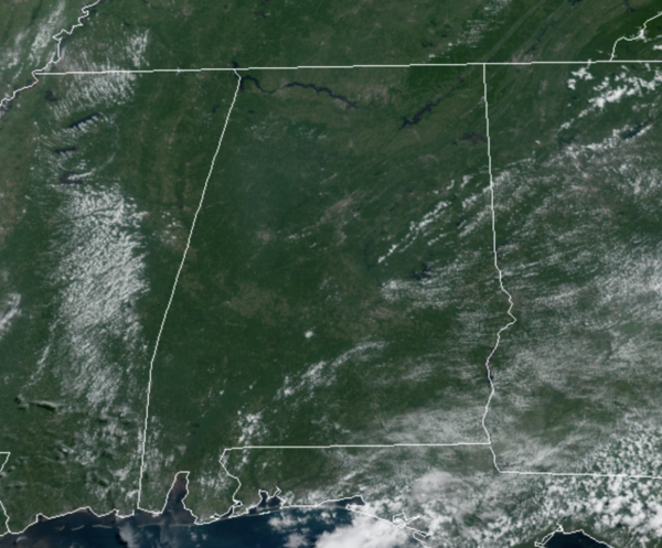
The strong upper ridge remains in place across Alabama and the Deep South, and is allowing for another dry and very hot day of weather. Today the sky is mainly sunny and temperatures will be surging into the mid-90s for much of North/Central Alabama, which is one of the hottest day of the summer for many locations.
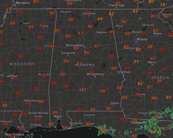
Heat index values are over 100°, and may approach the 105° Heat Advisory criteria at times. Showers and storms will remain rather isolated this afternoon, with the best chance of these occurring across South Alabama, but even there rain chances are generally less than 20%.
REST OF WEEK: Tomorrow the ridge remains in place, but rain chances will increase some as a wave of energy moves along the Northern Gulf Coast. We will need to add rain chances into the forecast, with some showers and storms, but still these will remain widely scattered with most locations remaining dry. Highs will be in the low to mid 90s. The upper ridge weakens some by Thursday and Friday, and we expect an increase in the number of scattered showers and thunderstorms both days with lower heat levels; the high both days will be in the 88-92 degree range.
IN THE TROPICS: There are no other active systems in the Atlantic, but there are three areas the NHC is monitoring. The next three names are Ida, Julian, and Kate.
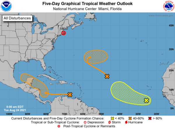
1. A broad trough of low pressure is producing disorganized showers and thunderstorms over the central tropical Atlantic about 900 miles east-northeast of the northern Leeward Islands. Little development of this system is expected during the next day or two due while it moves northwestward at about 15 mph over marginally conducive ocean temperatures and is affected by strong upper-level winds. Afterwards, environmental conditions are expected to become more favorable for gradual development, and a tropical depression could form by the end of the week while the system turns eastward over the central Atlantic. Formation chance through 5 days…medium…60 percent.
2. A broad area of low pressure is expected to form over the southwestern Caribbean Sea in a few days from a tropical wave currently located over the eastern Caribbean Sea. Environmental conditions are forecast to be conducive for development of the low, and a tropical depression could form late this week or this weekend while the system moves northwestward over the northwestern Caribbean Sea, across the Yucatan Peninsula of Mexico, and into the southwestern Gulf of Mexico by Sunday. Formation chance through 5 days…medium…60 percent.
3. Another tropical wave over the far eastern tropical Atlantic located about 400 miles south-southwest of the Cabo Verde Islands is producing a concentrated area of showers and thunderstorms. Some development of this system is possible over the next several days while it moves westward to west-northwestward at 10 to 15 mph over the eastern tropical Atlantic. Upper-level winds are forecast to become less conducive for development by the weekend. Formation chance through 5 days…low…30 percent.
BEACH FORECAST CENTER: Get the latest weather and rip current forecasts for the beaches from Fort Morgan to Panama City on our Beach Forecast Center page. There, you can select the forecast of the region that you are interested in visiting.
WORLD TEMPERATURE EXTREMES: Over the last 24 hours, the highest observation outside the U.S. was 119.8F at Al-ashraf International Airport, Iraq. The lowest observation was -97.1F at Amundsen-Scott South Pole Station, Antarctica.
CONTIGUOUS TEMPERATURE EXTREMES: Over the last 24 hours, the highest observation was 111F at Stovepipe Wells and Death Valley, CA. The lowest observation was 23F at Sand Creek Station, OR.
Category: Alabama's Weather, ALL POSTS
About the Author (Author Profile)
Macon, Georgia Television Chief Meteorologist, Birmingham native, and long time Contributor on AlabamaWX. Stormchaser. I did not choose Weather, it chose Me. College Football Fanatic. @Ryan_StinnetSubscribe
If you enjoyed this article, subscribe to receive more just like it.


