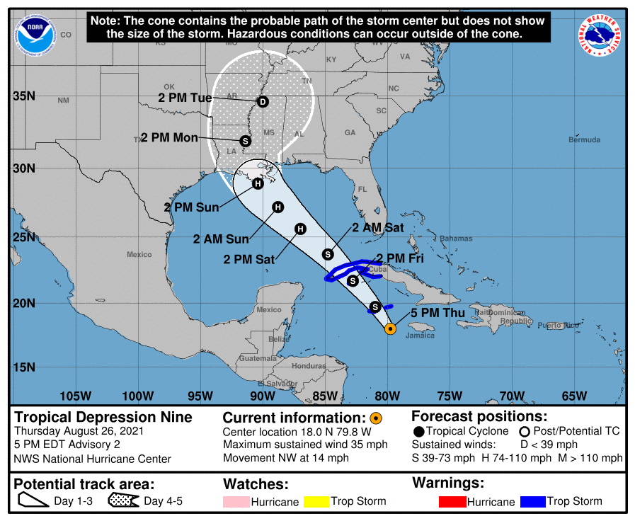
4 pm Advisory — TD-9 Stengthens Into Tropical Storm Ida to the Southeast of Grand Cayman
Air Force Reserve hurricane hunter aircraft data indicate that the Tropical Depression Nine has strengthened to Tropical Storm Ida. The maximum sustained winds are estimated to be 40 mph with higher gusts. Here is the latest from the National Hurricane Center:
SUMMARY OF 4 PM CDT INFORMATION
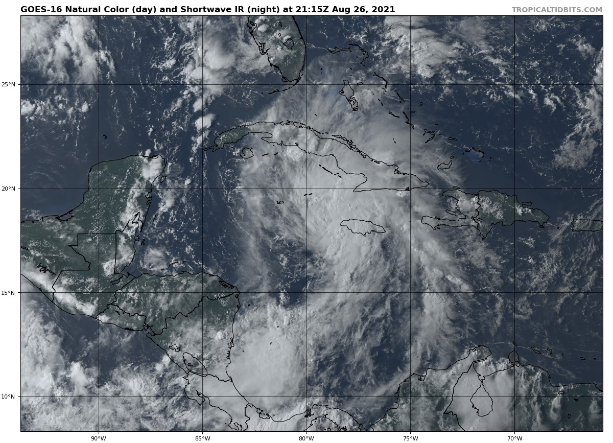
LOCATION…18.0N 79.8W
ABOUT 100 MI…160 KM WSW OF NEGRIL JAMAICA
ABOUT 130 MI…205 KM SE OF GRAND CAYMAN
MAXIMUM SUSTAINED WINDS…40 MPH…65 KM/H
PRESENT MOVEMENT…NW OR 325 DEGREES AT 14 MPH…22 KM/H
MINIMUM CENTRAL PRESSURE…1006 MB…29.71 INCHES
WATCHES AND WARNINGS
A Tropical Storm Warning is in effect for…
* Cayman Islands
* Cuban provinces of Matanzas, Mayabeque, Havana, Artemisa, Pinar del Rio, and the Isle of Youth
FORECAST DISCUSSION
At 500 PM EDT (2100 UTC), the center of Tropical Storm Ida was located near latitude 18.0 North, longitude 79.8 West. The depression is moving toward the northwest near 14 mph (22 km/h), and this general motion should continue over the next few days. On the forecast track, the center of the depression will pass near or over the Cayman Islands tonight, the Isle of Youth and western Cuba Friday, and over the southeastern and central Gulf of Mexico Friday night and Saturday. The system is forecast to approach the U.S. northern Gulf coast on Sunday.
Maximum sustained winds are near 35 mph (55 km/h) with higher gusts. Steady strengthening is forecast during the next few days. The depression is expected to become a tropical storm tonight, and become a hurricane when it is near western Cuba or over the southeastern Gulf of Mexico. Additional strengthening is likely over the Gulf of Mexico, and the system could be near major hurricane strength when it approaches the northern Gulf coast.
The estimated minimum central pressure from Air Force Reserve reconnaissance data is 1006 mb (29.71 inches).
KEY MESSAGES
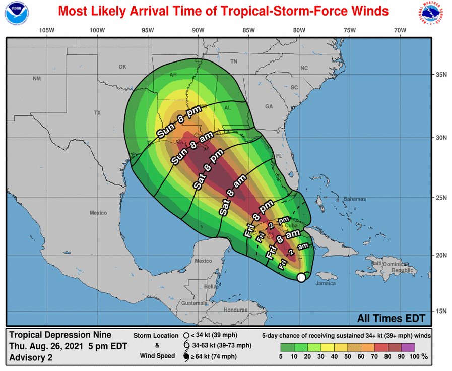
1. Tropical storm conditions are expected in portions of the Cayman Islands tonight, and in portions of western Cuba and the Isle of Youth Friday. Dangerous storm surge is possible Friday in portions of western Cuba, including the Isle of Youth, in areas of onshore flow.
2. Life-threatening heavy rains, flash flooding and mudslides are expected across Jamaica, the Cayman Islands, and western Cuba, including the Isle of Youth.
3. The system is forecast to approach the northern Gulf coast at or near major hurricane intensity on Sunday, where there is an increasing risk of life-threatening storm surge, damaging hurricane-force winds, and heavy rainfall Sunday and Monday, especially along the coast of Louisiana. Storm Surge and Hurricane watches will likely be issued for a portion of this area later tonight or Friday morning. Interests in these areas should closely monitor the progress of this system and follow any advice given by local officials.
HAZARDS TO LAND
STORM SURGE: A dangerous storm surge will raise water levels by as much as 2 to 4 feet above normal tide levels in areas of onshore winds along the immediate coast of the Isle of Youth and near and to the east of where the center crosses the coast of western Cuba. Near the coast, the surge will be accompanied by large and destructive waves.
WIND: Tropical storm conditions are expected in the Cayman Islands tonight, and are expected to reach the Isle of Youth and portions of western Cuba in the warning area on Friday.
RAINFALL: The depression is expected to produce total rainfall accumulations of 6 to 10 inches, with maximum totals of 15 inches across Jamaica. Rainfall totals of 8 to 12 inches with isolated maximum amounts of 20 inches are expected across the Cayman Islands and western Cuba, including the Isle of Youth. These rainfall amounts may produce life-threatening flash floods and mudslides.
The depression may begin to bring rainfall and potential flooding impacts to the central Gulf Coast by early Sunday.
SURF: Swells generated by this system will begin to affect Jamaica, the Cayman Islands and Cuba tonight and Friday. These swells are likely to cause life-threatening surf and rip current conditions.
All images, forecasts, and documents are courtesy of their respective publishers.
About the Author (Author Profile)
Scott Martin is an operational meteorologist, professional graphic artist, musician, husband, and father. Not only is Scott a member of the National Weather Association, but he is also the Central Alabama Chapter of the NWA president. Scott is also the co-founder of Racecast Weather, which provides forecasts for many racing series across the USA. He also supplies forecasts for the BassMaster Elite Series events including the BassMaster Classic.Subscribe
If you enjoyed this article, subscribe to receive more just like it.


