Quiet This Afternoon; A Hurricane Is Forecast To Be In The Gulf This Weekend
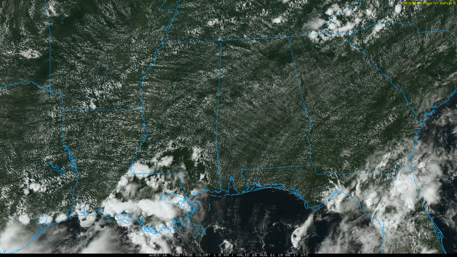
RADAR CHECK: So far showers and storms are very hard to find across Alabama this afternoon; the sky is mostly sunny with lower heat levels today… temperatures are mostly in the mid to upper 80s. We will have on to a chance of isolated showers through the evening hours, but it looks like most places will be dry through tonight.
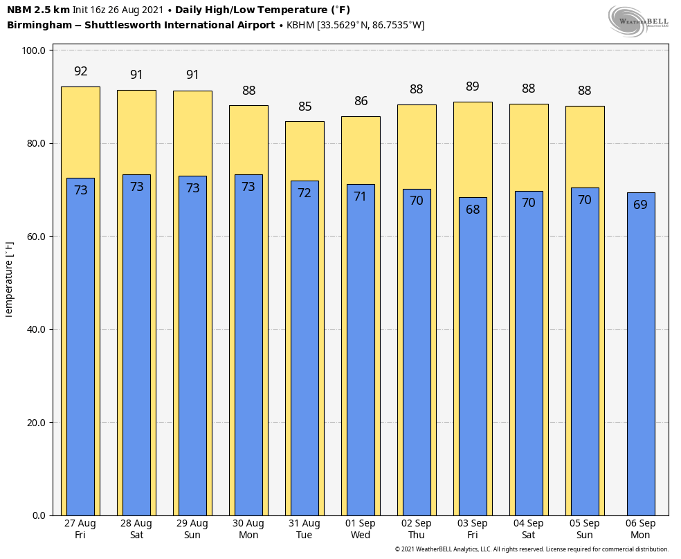
TOMORROW THROUGH SUNDAY: We expect routine weather tomorrow through the weekend… partly sunny days with scattered showers and storms, mostly from noon to midnight. The chance of any one spot getting wet each day is 20-30 percent, and highs will be in the 86-90 degree range.
NEXT WEEK: Ida is expected to make landfall on the Louisiana coast Sunday evening, and Alabama will be on the wet, unsettled side of the circulation. This will bring potential for widespread rain Monday and Tuesday, along with potential for flooding and a few tornadoes. But, there is still considerable uncertainty in the track, and it is a little early to define where the greatest flood and tornado threat will be. The weather trends drier over the latter half of the week… See the Weather Xtreme video for maps, graphics, and more details.
TROPICS: Two tropical waves in the Atlantic now have a high chance of becoming a tropical depression or storm over the next five days, but those are not expected to impact the U.S.
TROPICAL DEPRESSION NINE: Newly formed Tropical Depression Nine is forecast to become Tropical Storm Ida soon. The system is west of Jamaica, in the Caribbean, and is moving northwest at about 15 mph. NHC is forecasting the system to reach hurricane strength in the southern Gulf of Mexico Saturday morning, followed by landfall on the Louisiana coast Sunday afternoon or evening.
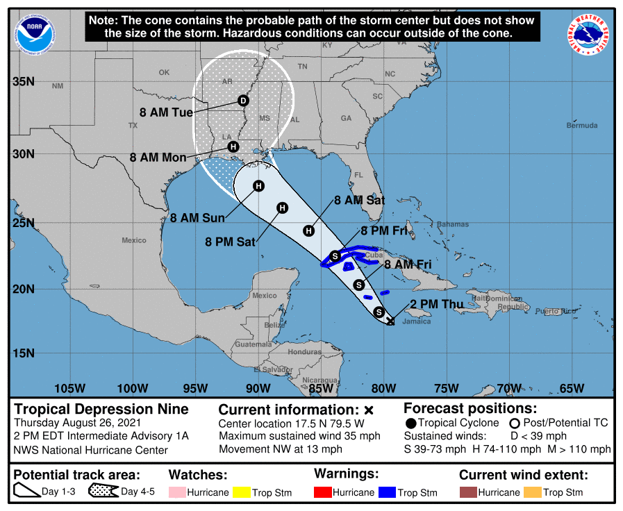
The NHC intensity forecast brings the system near major hurricane strength when it approaches Louisiana coast on Sunday. This forecast is supported by model guidance, which all significantly deepen the cyclone over the Gulf of Mexico. As a result, there is higher-than-normal confidence that a strengthening tropical cyclone will be moving over the Gulf this weekend. There is a risk of life-threatening storm surge, damaging hurricane-force winds, and heavy rainfall Sunday and Monday along the northern Gulf Coast from the Florida Panhandle to the upper Texas coast, with the greatest risk along the coast of Louisiana.
COASTAL IMPACT: It is important to note that it is too early for a specific impact forecast for any point on the Gulf Coast since the system has just formed, and is still in the Caribbean. Remember the main impact in terms of wind, flooding, and storm surge will be along the east of the landfall point. For now, it looks like the highest impact will come across Southeast Louisiana and the Mississippi coast, but there will some rain and wind as well as far east as the Alabama and Northwest Florida coasts. Dangerous rip currents are likely all along the Central Gulf Coast Saturday through Monday; expect double red flags.
We will be much more specific on the coastal impact for places like Gulf Shores, Destin, and Panama City Beach tomorrow.
INLAND IMPACT: Ida will likely bring the threat of flooding to much of Mississippi and Alabama Sunday night through Tuesday. Rain amounts could easily exceed six inches across parts of these two states, but again it is too early to define the axis of the heaviest expected rain. And, isolated tornadoes will be a possibility Monday and Tuesday across East Mississippi and Alabama.
Please keep up with the latest updates on this tropical system as it moves toward the Gulf Coast over the next few days. If you are working with old information, you are working with bad information.
ON THIS DATE IN 1976: A weak tornado touched down briefly in the Hockley Hills near Kiana, AK, about 29 miles north of the Arctic Circle. This tornado is the most northerly report of a tornado on record. Kiana is 545 miles northwest of Anchorage, Alaska.
ON THIS DATE IN 1992: Hurricane Andrew made a second landfall near Burns Point, LA as a Category 3 hurricane. Morgan City, LA recorded sustained winds of 92 mph with a peak gust of 108 mph. Hammond, LA was deluged with 11.92 inches of rain. As Andrew moved inland and weakened, it spawned 47 tornadoes from this date through the 28th from the South to the Mid-Atlantic States.
BEACH FORECAST: Click here to see the AlabamaWx Beach Forecast Center page.
WEATHER BRAINS: Don’t forget you can listen to our weekly 90 minute show anytime on your favorite podcast app. This is the show all about weather featuring many familiar voices, including our meteorologists here at ABC 33/40.
CONNECT: You can find me on all of the major social networks…
Look for the next Weather Xtreme video here by 6:00 a.m. tomorrow…
Category: Alabama's Weather, ALL POSTS, Weather Xtreme Videos
About the Author (Author Profile)
James Spann is one of the most recognized and trusted television meteorologists in the industry. He holds the AMS CCM designation and television seals from the AMS and NWA. He is a past winner of the Broadcast Meteorologist of the Year from both professional organizations.Subscribe
If you enjoyed this article, subscribe to receive more just like it.


