10 am Advisory — Ida Continues to Strengthen & Should Be at Hurricane Strength Later Today
SUMMARY OF 10 AM CDT INFORMATION
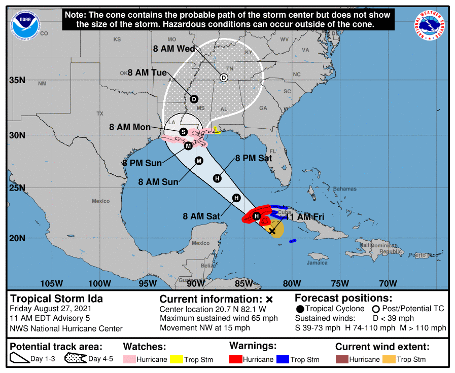
LOCATION…20.7N 82.1W
ABOUT 75 MI…125 KM SE OF THE ISLE OF YOUTH
ABOUT 200 MI…320 KM ESE OF THE WESTERN TIP OF CUBA
MAXIMUM SUSTAINED WINDS…65 MPH…100 KM/H
PRESENT MOVEMENT…NW OR 320 DEGREES AT 15 MPH…24 KM/H
MINIMUM CENTRAL PRESSURE…996 MB…29.42 INCHES
WATCHES AND WARNINGS
A Hurricane Warning is in effect for…
* Cuban provinces of Pinar del Rio and Artemisa, and the Isle of Youth
A Storm Surge Watch is in effect for…
* Sabine Pass to Alabama/Florida border
* Vermilion Bay, Lake Borgne, Lake Pontchartrain, Lake Maurepas, and Mobile Bay
A Hurricane Watch is in effect for…
* Cameron, Louisiana to the Mississippi/Alabama border
* Lake Pontchartrain, Lake Maurepas, and Metropolitan New Orleans
A Tropical Storm Warning is in effect for…
* Little Cayman and Cayman Brac
* Cuban provinces of Matanzas, Mayabeque, and Havana
A Tropical Storm Watch is in effect for…
* Mississippi/Alabama border to the Alabama/Florida border.
FORECAST DISCUSSION
At 1100 AM EDT (1500 UTC), the center of Tropical Storm Ida was located near latitude 20.7 North, longitude 82.1 West. Ida is moving toward the northwest near 15 mph (24 km/h), and this general motion should continue over the next few days. On the forecast track, the center of Ida will pass near or over the Isle of Youth and western Cuba later today, and move over the southeastern and central Gulf of Mexico tonight and Saturday. Ida is forecast to make landfall along the U.S. northern Gulf coast within the hurricane watch area on Sunday.
Reports from Air Force and NOAA reconnaissance aircraft indicate that the maximum sustained winds have increased to near 65 mph (100 km/h) with higher gusts. Additional strengthening is forecast today, and Ida is expected to be a hurricane when it nears western Cuba later today. Steady to rapid strengthening is expected when Ida moves over the southeastern and central Gulf of Mexico over the weekend, and Ida is expected to be a major hurricane when it approaches the northern Gulf coast.
Tropical-storm-force winds extend outward up to 90 miles (150 km) from the center. A wind gust to 45 mph (72 km/h) was recently reported on Cayman Brac and a wind gust to 41 mph (67 km/h) has been observed on Cayo Largo, Cuba, within the past hour or two. The latest minimum central pressure reported by an Air Force Reserve reconnaissance aircraft is 996 mb (29.42 inches).
KEY MESSAGES
1. Life-threatening storm surge and hurricane conditions are expected later today and tonight in portions of western Cuba, including the Isle of Youth, where a Hurricane Warning is in effect. Life-threatening heavy rains, flash flooding and mudslides are expected across Jamaica, the Cayman Islands, and western Cuba, including the Isle of Youth.
2. The risk of life-threatening storm surge inundation is increasing along the coasts of Louisiana, Mississippi, and Alabama. Inundation of 7 to 11 feet above ground level is possible within the area from Morgan City, Louisiana, to Ocean Springs, Mississippi, including Lake Borgne. Interests in these areas should follow any advice given by local officials.
3. Ida is expected to be a dangerous major hurricane when it reaches the northern Gulf Coast on Sunday, and the risk of hurricane-force winds continues to increase, especially along portions of the Louisiana coast, including metropolitan New Orleans. Potentially devastating wind damage could occur where the core of Ida moves onshore.
4. Ida is likely to produce heavy rainfall later Sunday into Monday across the central Gulf Coast from southeast Louisiana to coastal Mississippi and Alabama, as well as the Lower Mississippi Valley, resulting in considerable flash, urban, small stream, and riverine flooding.
All images, forecasts, and documents are courtesy of their respective publishers.
Category: Alabama's Weather, ALL POSTS, Severe Weather, Tropical
About the Author (Author Profile)
Scott Martin is an operational meteorologist, professional graphic artist, musician, husband, and father. Not only is Scott a member of the National Weather Association, but he is also the Central Alabama Chapter of the NWA president. Scott is also the co-founder of Racecast Weather, which provides forecasts for many racing series across the USA. He also supplies forecasts for the BassMaster Elite Series events including the BassMaster Classic.Subscribe
If you enjoyed this article, subscribe to receive more just like it.


