Midday Nowcast: Some Storms Today; Watching Ida Carefully
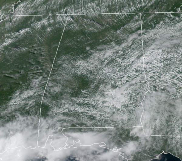
For Alabama through Sunday, the weather is pretty typical of late August…It is hot, humid, there is a mix of sun and clouds, and scattered afternoon and evening showers and storms moving randomly about the Alabama landscape. Temperatures will be ranging from the upper 80s to lower 90s each afternoon. Late Sunday, as Hurricane Ida approaches the Gulf Coast, clouds and rain will be increasing.
ALL EYES ON IDA: The center of Tropical Storm Ida was located near latitude 20.7 North, longitude 82.1 West. Ida is moving toward the northwest near 15 mph, and this general motion should continue over the next few days. On the forecast track, the center of Ida will pass near or over the Isle of Youth and western Cuba later today, and move over the southeastern and central Gulf of Mexico tonight and Saturday. Ida is forecast to make landfall along the U.S. northern Gulf coast within the hurricane watch area on Sunday.
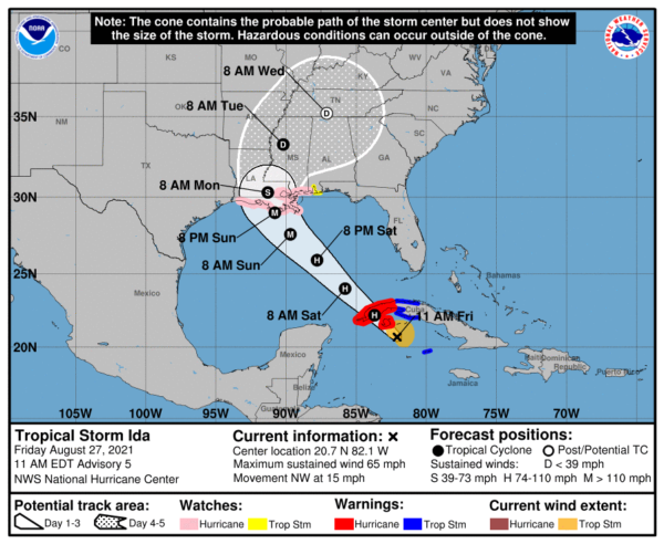
Reports from Air Force and NOAA reconnaissance aircraft indicate that the maximum sustained winds have increased to near 65 mph with higher gusts. Additional strengthening is forecast today and Ida is expected to be a hurricane when it nears western Cuba later today. Steady to rapid strengthening is expected when Ida moves over the southeastern and central Gulf of Mexico over the weekend, and Ida is expected to be a major hurricane when it approaches the northern Gulf coast.
Tropical-storm-force winds extend outward up to 90 miles from the center. A wind gust to 45 mph was recently reported on Cayman Brac and a wind gust to 41 mph has been observed on Cayo Largo, Cuba, within the past hour or two. The latest minimum central pressure reported by an Air Force Reserve reconnaissance aircraft is 996 mb (29.42 inches).
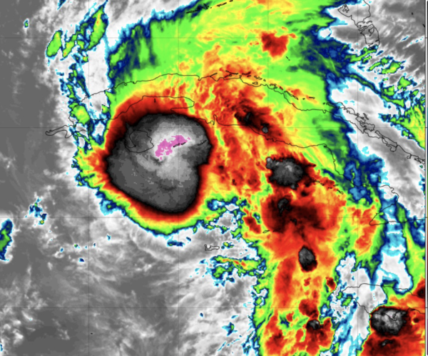
Although there is still some southwesterly shear over Ida, the outflow has begun to expand over the northeastern and southeastern portions of the circulation. The upper-level trough near the Yucatan peninsula that has been imparting the shear over Ida is forecast to weaken and move westward, which should result in a more favorable upper-level wind pattern. This, in combination with warm sea surface temperatures and a moist environment along the forecast track of the storm are expected to result in steady to rapid strengthening. In addition to the increase in strength, Ida’s wind field will grow larger as it moves over the Gulf of Mexico.
A mid-level ridge over the western Atlantic is forecast to move westward and this should keep Ida on a general northwestward heading during the next 48-60 hours. This track will bring the storm across western Cuba later today, over the southeastern and central Gulf of Mexico on Saturday and Saturday night, to the coast of Louisiana by late Sunday. The track guidance is in remarkably good agreement with very little cross-track spread during the first 60 hours or so of the forecast period. After that time, Ida is forecast to reach the western portion of the ridge, which is expected to cause the storm to slow down and turn northward and then northeastward over the southeastern United States.
Key Messages:
1. The risk of life-threatening storm surge inundation is increasing along the coasts of Louisiana, Mississippi, and Alabama. Inundation of 7 to 11 feet above ground level is possible within the area from Morgan City, Louisiana, to Ocean Springs, Mississippi, including Lake Borgne. Interests in these areas should follow any advice given by local officials.
2. Ida is expected to be a dangerous major hurricane when it reaches the northern Gulf Coast on Sunday, and the risk of hurricane-force winds continues to increase, especially along portions of the Louisiana coast, including metropolitan New Orleans. Potentially devastating wind damage could occur where the core of Ida moves onshore.
3. Ida is likely to produce heavy rainfall later Sunday into Monday across the central Gulf Coast from southeast Louisiana to coastal Mississippi and Alabama, as well as the Lower Mississippi Valley, resulting in considerable flash, urban, small stream, and river flooding.
4. Tornadoes are a concern with any landfalling tropical system, and we could see these over much of Southeast Louisiana, Mississippi, Alabama, and Northwest Florida.
NEXT WEEK: For now, the NHC is forecasting the circulation of Ida to move through Mississippi Monday and Tuesday, winding up near Muscle Shoals Tuesday night. This puts Alabama on the wet, unsettled east side of the system… rain over West and Southwest Alabama Monday will spread northward, and much of the state will have widespread rain Monday night and Tuesday. The rain could be heavy at times, and flooding issues are possible. Rain amounts will be in the 3-5 inch range over the western half of the state, with amounts of 1-3 inches for the eastern counties.
In addition to the flooding risk, some quick spin-up tornadoes are expected as the system moves inland. These will be a threat statewide Monday night and Tuesday, but uncertainty still remains and it is a little too early to know the magnitude of the tornado threat.
The system will pull away from the state on Wednesday and drier air will be pulled down into state Thursday and Friday with lots of sunshine both days along with lower humidity levels.
ELSEWHERE IN THE TROPICS: Two other areas of concern that could become Julian and Kate, but neither are a threat to the U.S.
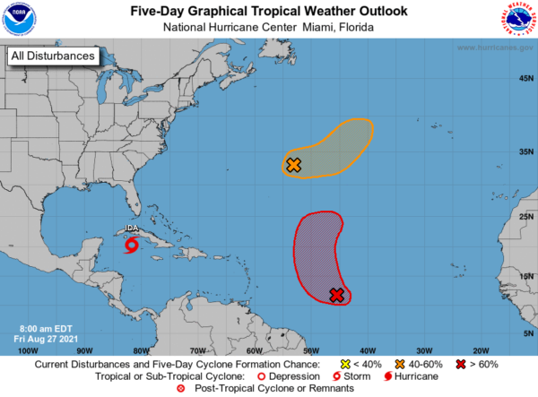
1. An elongated area of low pressure located over the central Atlantic about 600 miles east of Bermuda is producing showers and thunderstorms. Environmental conditions are expected to be marginally conducive for development, however, a tropical depression could still form over the weekend. The system is expected to drift eastward today and Saturday, then accelerate northeastward on Sunday toward the central-north Atlantic. Formation chance through 48 hours…medium…50 percent.
2. A tropical wave located about midway between the Cabo Verde Islands and the Lesser Antilles is producing limited showers and thunderstorms. Gradual development of this system is expected, however, and a tropical depression is likely to form during the next couple of days before it moves into an environment of stronger upper-level winds and slightly cooler waters. The disturbance is forecast to move west-northwestward today, then turn northward Saturday. Formation chance through 48 hours…high…70 percent.
BEACH FORECAST CENTER: Get the latest weather and rip current forecasts for the beaches from Fort Morgan to Panama City on our Beach Forecast Center page. There, you can select the forecast of the region that you are interested in visiting.
WORLD TEMPERATURE EXTREMES: Over the last 24 hours, the highest observation outside the U.S. was 124.3F at Basrah International Airport, Iraq. The lowest observation was -98.5F at University Dome, Antarctica.
CONTIGUOUS TEMPERATURE EXTREMES: Over the last 24 hours, the highest observation was 118F at Ocotillo Wells, CA. The lowest observation was 24F at Bodie, CA.
Category: Alabama's Weather, ALL POSTS
About the Author (Author Profile)
Macon, Georgia Television Chief Meteorologist, Birmingham native, and long time Contributor on AlabamaWX. Stormchaser. I did not choose Weather, it chose Me. College Football Fanatic. @Ryan_StinnetSubscribe
If you enjoyed this article, subscribe to receive more just like it.


