Saturday’s Weather Xtreme — All Eyes on Hurricane Ida
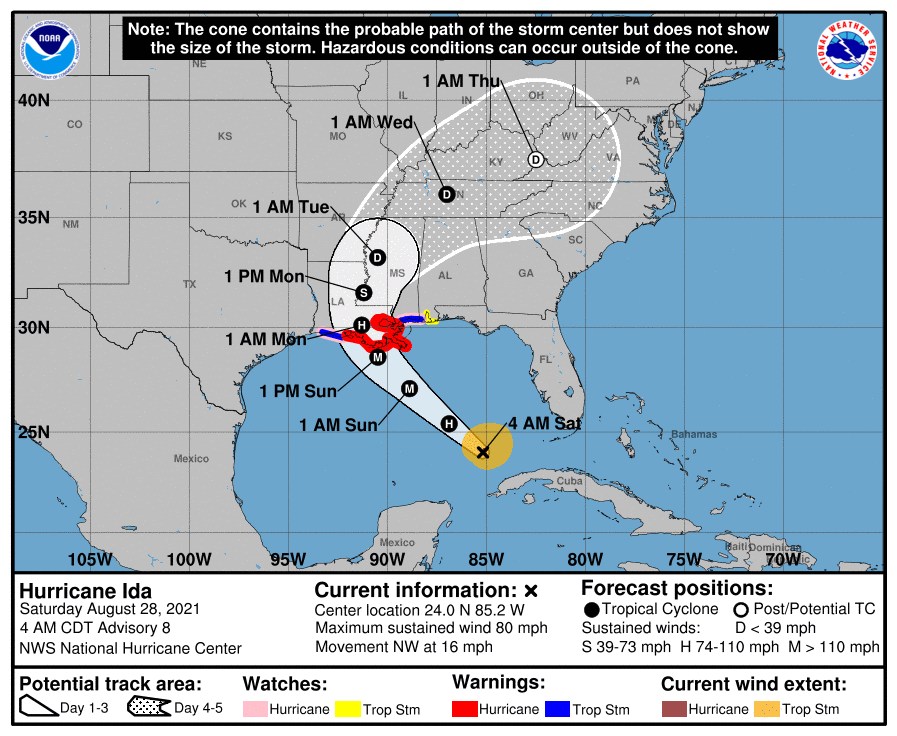
HURRICANE IDA: As of the 4 am update from the National Hurricane Center, Ida is moving northwestward across the southeastern Gulf of Mexico with maximum sustained winds at 80 mph. The center was located around 510 miles to the southeast of New Orleans and was moving at 16 mph. The forecast track shows that Ida will continue to the northwest across the Gulf of Mexico while rapidly strengthening, potentially reaching category four strength with winds up to 140 mph. For now, landfall is expected to occur close to Morgan City, but the impacts of Ida will be felt many miles out from the eye.
Hurricane warnings are up from Intracoastal City, Louisiana, to the Mouth of the Pearl River in Mississippi, including Lake Pontchartrain. Tropical storm warnings and hurricane watches are up outside of that as far east as the Mississippi/Alabama border and as far west as Cameron, Louisiana.
Storm surge warnings are up for just east of Rockefeller Wildlife Refuge in Louisiana to the Mississippi/Alabama border, and for Vermilion Bay, Lake Borgne, Lake Pontchartrain, and Lake Maurepas. Extremely life-threatening surge of 10 to 15 feet above ground level is possible within portions of the warned area. Life-threatening rip currents will occur from today through at least Wednesday along the northern Gulf Coast.
Unfortunately, potentially catastrophic wind damage is possible where the core of Ida moves onshore in the hurricane warning area starting as early as Sunday morning, including the New Orleans metropolitan area. Actions to protect life and property should be rushed to completion in the warning area, as landfall of the eye is expected to occur at the start of Sunday evening.
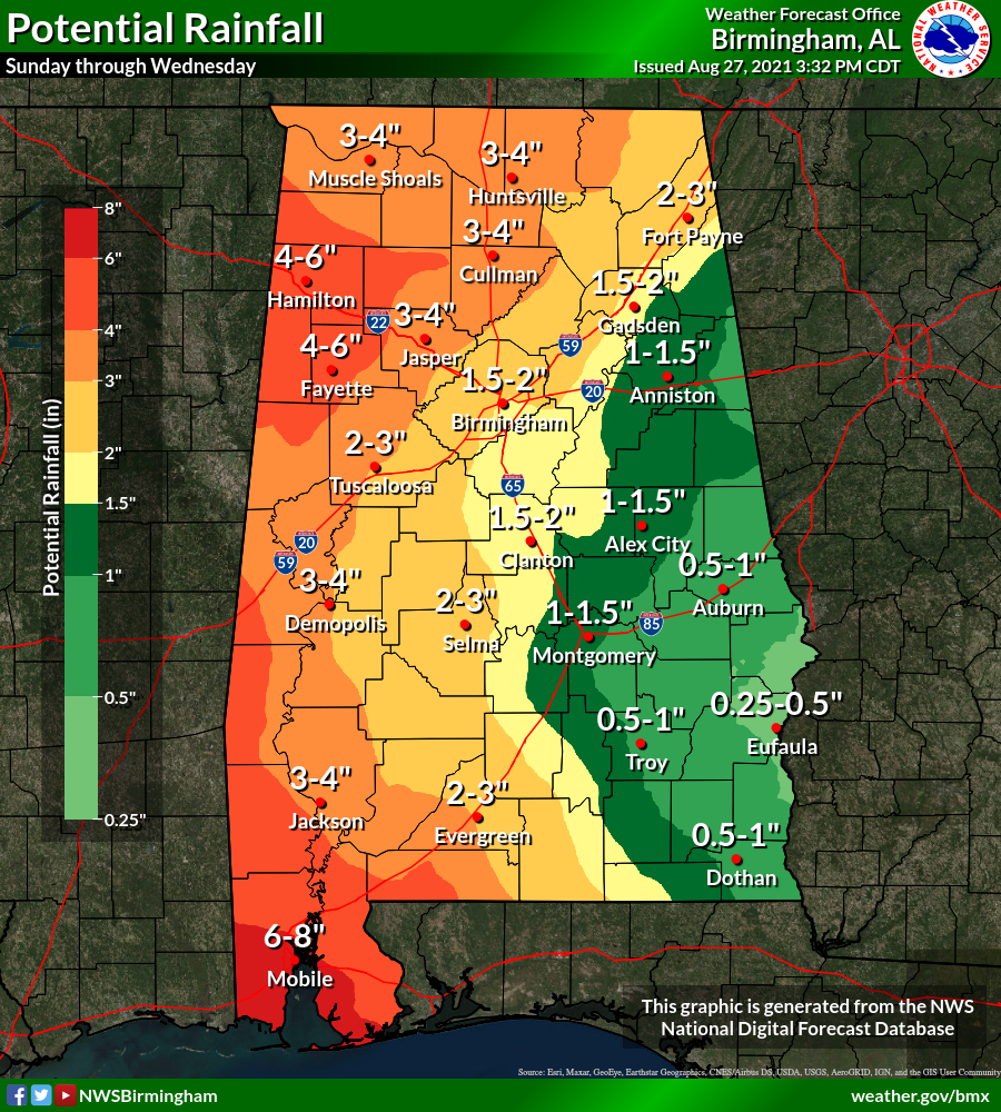
CENTRAL ALABAMA IMPACTS: For Central Alabama, we will start to see those impacts from Ida on Monday and will persist through much of Tuesday. Rainfall total will range from as small as around 1/4-inch for the southeastern parts of the area to as high as 4-6 inches over the northwest and western parts of the area. Some localized amounts may be even higher. There will be the potential for flooding in those low-lying and poor drainage areas. It will be breezy as wind gusts may reach as high as 40 mph in the west and northwestern parts of the area and in the higher elevations.
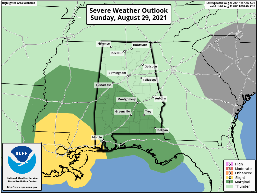
A few tropical-type brief spin-up tornadoes will be possible during that time frame as well and the Storm Prediction Center has the southwestern quarter of the area in a marginal risk for severe storms on the day two Severe Weather Outlook due to the tornado threat during the pre-dawn hours on Monday, and much of the western half of the area throughout the day on Monday and into the pre-dawn hours on Tuesday on the day three Severe Weather Outlook.
Just remember that these projected impacts could change with each update to Ida’s forecast track. Any jog to the east with the track means impacts may be greater to Central Alabama, while any jog to the west may lessen those impacts. That is why it is very important that you have the latest information on Ida. Old information is likely to be bad information.
THIS WEEKEND: It will be your pretty typical late summer day in Central Alabama today, as we’ll have partly cloudy skies with isolated to scattered, mainly afternoon showers and storms. Highs will be in the upper 80s to the lower 90s.
On Sunday, we’ll start to see the outer bands start to move into the extreme southwestern parts of Central Alabama as Ida will be making landfall on the Louisiana coast. Scattered to numerous showers and storms will be possible across much of the area, with the best coverage of storms occurring mainly south of a line from Tuscaloosa to Clanton to Troy. Highs will be in the upper 80s to the lower 90s.
THE WORK WEEK AHEAD: Showers and storms will become likely across the area, as we’ll be on the wet and active side of Ida as she moves roughly up the Mississippi River. Once again, it will be breezy with gusts up to 40 mph possible in the western portions of the area, and a few brief spin-up tornadoes are possible as well. Highs will be in the lower 80s to around 90 degrees across the area.
The center of Ida will be just west of Nashville on Tuesday afternoon, and we’ll continue to see showers and thunderstorms across the area. A few tornadoes may be possible once again for the west and northwestern parts of the area through the first-half of the day until the center makes it up into Tennessee. It will be a little breezy once again and highs will be in the upper 70s to the upper 80s.
We’ll continue to be in rather moist air that will be left over from Ida that will keep to potential for scattered showers and storms at times on Wednesday, but coverage will more spotty than what we will see on Monday and Tuesday. Highs will be in the 80s.
Drier air moves in to finish out the work week, as we’ll have plenty of sunshine and only a very small chance of an isolated shower or two on both days. Highs will be in the mid-80s to the lower 90s.
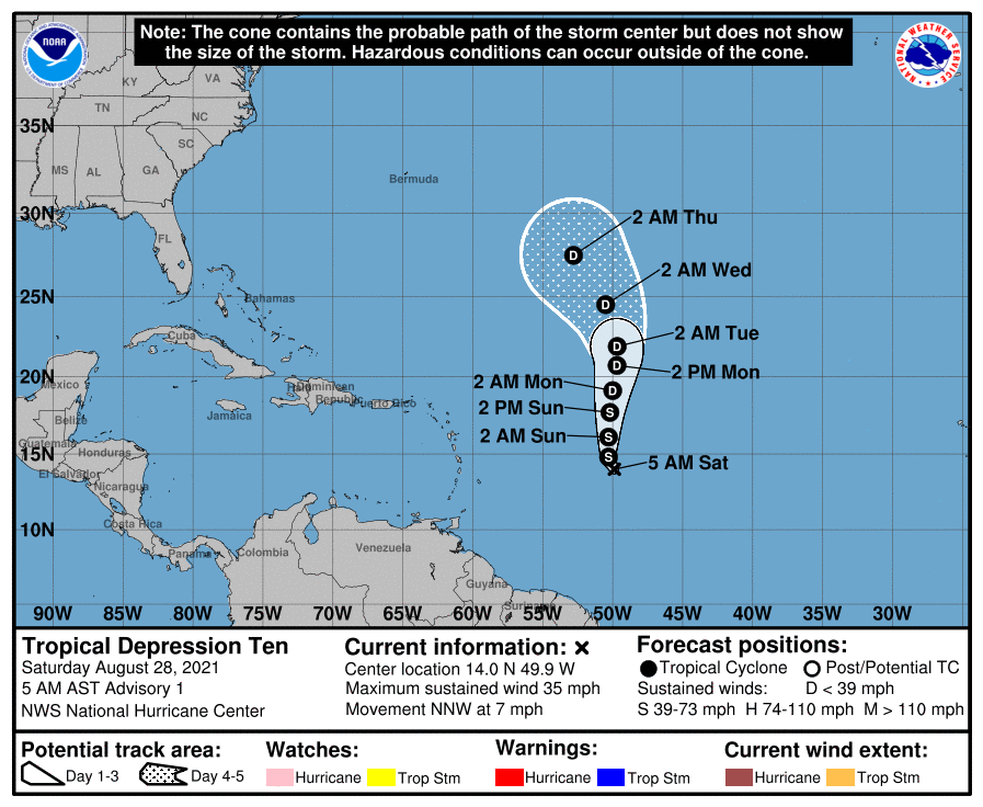
THE TROPICS: We have Tropical Depression Ten on the board, and it is expected to become Tropical Storm Julian later today. It will move northward and eventually weaken back into a depression. At this point, it will be no threat to the continental USA.
Category: Alabama's Weather, ALL POSTS, Severe Weather, Tropical, Weather Xtreme Videos
About the Author (Author Profile)
Scott Martin is an operational meteorologist, professional graphic artist, musician, husband, and father. Not only is Scott a member of the National Weather Association, but he is also the Central Alabama Chapter of the NWA president. Scott is also the co-founder of Racecast Weather, which provides forecasts for many racing series across the USA. He also supplies forecasts for the BassMaster Elite Series events including the BassMaster Classic.Subscribe
If you enjoyed this article, subscribe to receive more just like it.


