A Special Sunday Weather Xtreme Video: Hurricane Ida On Final Approach to Louisiana, Still Strengthening
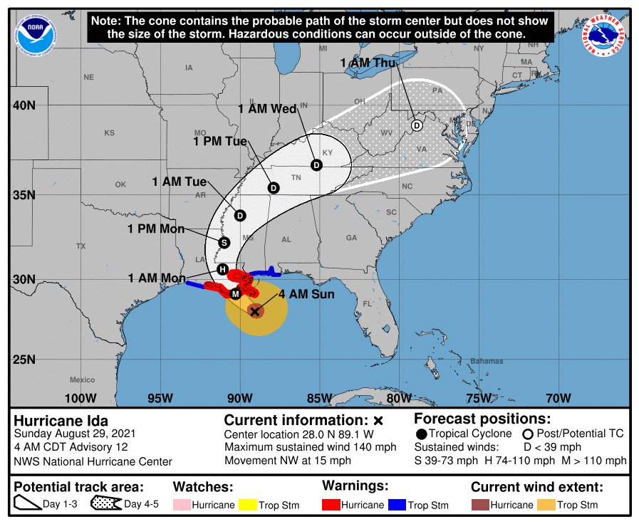
EXPLOSIVE DEEPENING: The pressure in Hurricane Ida dropped 20 millibars between 10 a.m. and 10 p.m. last night and since then it has dropped another 18 millibars. Top winds in the storm have risen from 85 mph to 140 mph in twenty-four hours. That’s not just rapid intensification, that’s explosive deepening. The center of Hurricane Ida is now clearly visible on radar along the Gulf Coast. It is now just 95 miles southeast of Houma and about the same distance south southeast of New Orleans. It is moving northwest at 15 mph and will come inland along the Louisiana coast just west of Grand Isle just after noon today with top winds around 145 mph. The center of the storm will track northwestward passing near or just east of Houma and then west of New Orleans late this afternoon. It will move near Baton Rouge late tonight and into the Mississippi Delta northwest of Jackson tomorrow afternoon. By Tuesday morning, it will be passing near the Northwest Corner of Alabama before heading toward Kentucky, West Virginia, and eventually Pennsylvania.
LIFE ALTERING STORM: That’s what Ben Schott of the NWS in New Orleans prophetically called the storm in a news conference on Friday. He will be right. Winds of 100-140 mph sustained with gusts to 160 will impact the southern Parishes of Southeast Louisiana southwest of New Orleans with a devastating impact. Those winds will advance northwestward, weakening slowly with time. Tropical storm force winds will reach New Orleans early this morning, by 8-9 a.m. Sustained winds over 100 mph will impact Lafourche and Terrebonne Parishes as the hurricane moves NNW. Hurricane force gusts will be moving into New Orleans early afternoon. Winds will be gusting to 130-145 mph in the eyewall east of the center. In New Orleans, winds will be gusting to 90-95 mph. By 7 p.m., the center will be passing just west of New Orleans. Sustained winds will be around 50-70 mph and will be gusting to over 100-105 mph just east of the center. New Orleans will be feeling those 90-105 mph gusts. Areas from Baton Rouge to along the NorthShore, including Hammond, Covington, and Mandeville will start seeing hurricane force gusts. Those gusts will increase to around 90-100 mph through midnight. Hurricane force gusts will continue through 2-3 a.m. Tropical storm force gusts will persist until late Monday afternoon. The eye may pass very near Baton Rouge around 3-4 a.m. Winds will begin to diminish in Baton Rouge and along the NorthShore through the early morning hours, but tropical storm force gusts will persist into Monday afternoon.
HOW ‘BOUT US? Sounds like a song by Champagne from the 70s, but it’s an important question. Skies will gradually become cloudier through the day today. Highs will still be in the upper 80s to near 90F, except over Southwest Alabama. The outer bands of Hurricane Ida will impact South Alabama and Northwest Florida through the morning. One of these outer bands will work its way up into Central Alabama, as far north as Birmingham by 5-6 p.m. and into North Alabama overnight. Can’t rule out an isolated tornado or severe thunderstorm with these storms. A more powerful outer band will move up into Southwest Alabama during the early morning hours, and a large shield of rain and thunderstorms will push northeastward across our state tomorrow. Rainfall amounts could be heavy, averaging 2-4 inches over areas west of I-65 and 1-2 inches over eastern Alabama. Severe weather is likely tomorrow, especially with any feeder bands that can form ahead of the main rain shield. Winds will become gusty tomorrow night, reaching 15-25 mph with gusts to 35 in spots, and winds will remain gusty through most of Tuesday. Monday highs will only make it to the lower 80s. The rain and storms should diminish Tuesday and highs will top out near 80F.
REST OF THE WEEK: A few lingering showers can be expected Wednesday, but the rest of the week will be dry and slightly cooler? Highs will rise back toward the middle 80s, but lows will be in the lower and middle 60s. The weekend even kicks off with fair weather.
BEACHCAST: Mostly cloudy skies with rain and storms along the beautiful beaches of Alabama and Northwest Florida through mid-week. The weekend looks nicer. Surf Heights will be 10-15 feet today and 8-12 feet tomorrow. As you would expect, the rip current index is sky high, so stay out of the water. Highs will be in the middle and upper 80s to near 90F. Lows will be in the mid and upper 70s.
Click here to see the Beach Forecast Center page.
THREE OTHER SYSTEMS WE’RE NOT TALKING ABOUT: Tropical Depressions Ten and Eleven formed yesterday, but they should pass harmlessly out to sea.
ADVERTISE WITH US: Deliver your message to a highly engaged audience by advertising on the AlabamaWX.com website. The site enjoyed 29 MILLION page views in the past 12 months. Don’t miss out! We can customize a creative, flexible and affordable package that will suit your organization’s needs. Contact me, Bill Murray, at (205) 687-0782, and let’s talk.
WEATHERBRAINS: This week, the panel will entertain a group out of the National Severe Storms Laboratory in Norman, Oklahoma. We hear famous Alabama musician Wet Willie will also make an appearance! The show is scheduled to be recorded at 8 p.m. tomorrow evening, but could be delayed by Ida. You can always check out the show at www.WeatherBrains.com. You can also subscribe on iTunes. You can watch the show live at live.bigbrainsmedia.com or on James’ YouTube Channel You will be able to see the show on the James Spann 24×7 weather channel on cable or directly over the air on the dot 2 feed.
ON THIS DATE IN 1962: Of course, we take satellite imagery for granted today, but 1962 was the first season for hurricane forecasters to have the new technology at their disposal. On this date that year, forecasters spotted a feature on the TIROS satellite images that suggested a tropical storm had formed over the far eastern Atlantic. Ship reports confirmed that the following day. Follow my weather history tweets on Twitter. I am @wxhistorian at Twitter.com.
Category: Alabama's Weather, ALL POSTS, Tropical
About the Author (Author Profile)
Bill Murray is the President of The Weather Factory. He is the site's official weather historian and a weekend forecaster. He also anchors the site's severe weather coverage. Bill Murray is the proud holder of National Weather Association Digital Seal #0001 @wxhistorianSubscribe
If you enjoyed this article, subscribe to receive more just like it.


