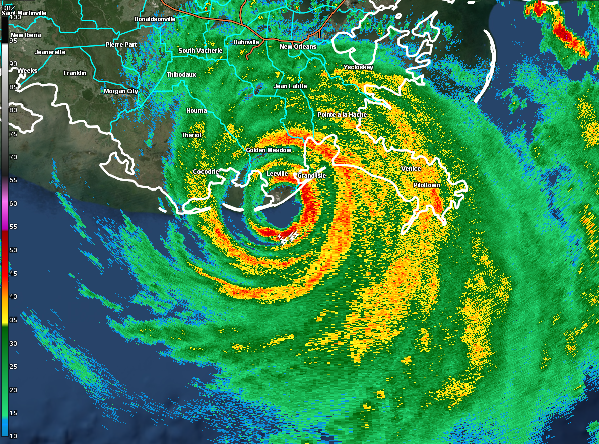
Category 4 Hurricane Ida Makes Landfall Near Port Fourchon, Louisiana
SUMMARY OF 1155 AM CDT…1655 UTC…INFORMATION
———————————————–
LOCATION…29.1N 90.2W
ABOUT 15 MI…25 KM SW OF GRAND ISLE, LOUISIANA
ABOUT 45 MI…75 KM SE OF HOUMA, LOUISIANA
MAXIMUM SUSTAINED WINDS…150 MPH…240 KM/H
PRESENT MOVEMENT…NW OR 320 DEGREES AT 13 MPH…20 KM/H
MINIMUM CENTRAL PRESSURE…930 MB…27.46 INCHES
NOAA Doppler radar imagery indicates that the eye of Ida made landfall along the southeastern coast of Louisiana near Port Fourchon around 1155 AM CDT (1655 UTC). Data from an Air Force Reserve reconnaissance aircraft and Doppler radar data indicate that Ida’s maximum sustained winds at landfall were estimated to be 150 mph (240 km/h). The latest minimum central pressure estimated from reconnaissance aircraft data is 930 mb (27.46 in).
Within the past hour, sustained winds of 43 mph (69 km/h) and a gust to 67 mph (107 km/h) were reported at Lakefront Airport in New Orleans.
A NOAA National Ocean Service tide gauge in Shell Beach, Louisiana, recently reported a water level of 6.4 feet above mean higher high water, which is an approximation of inundation in that area.
A NOAA National Ocean Service tide gauge at Bay Waveland Yacht Club, Mississippi, recently reported a water level of 5.5 feet above mean higher high water, which is an approximation of inundation in that area.
Category: ALL POSTS, Severe Weather, Tropical
About the Author (Author Profile)
Scott Martin is an operational meteorologist, professional graphic artist, musician, husband, and father. Not only is Scott a member of the National Weather Association, but he is also the Central Alabama Chapter of the NWA president. Scott is also the co-founder of Racecast Weather, which provides forecasts for many racing series across the USA. He also supplies forecasts for the BassMaster Elite Series events including the BassMaster Classic.Subscribe
If you enjoyed this article, subscribe to receive more just like it.


