4 pm Advisory — Catastrophic Storm Surge, Extreme Winds, & Flash Flooding Continues in Portions of Southeast Louisiana
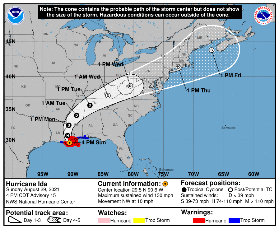
SUMMARY OF 4 PM CDT INFORMATION
LOCATION…29.5N 90.6W
ABOUT 45 MI…75 KM SW OF NEW ORLEANS LOUISIANA
ABOUT 70 MI…115 KM SSE OF BATON ROUGE LOUISIANA
MAXIMUM SUSTAINED WINDS…130 MPH…215 KM/H
PRESENT MOVEMENT…NW OR 325 DEGREES AT 10 MPH…17 KM/H
MINIMUM CENTRAL PRESSURE…938 MB…27.70 INCHES
WATCHES AND WARNINGS
A Storm Surge Warning is in effect for…
* Morgan City, Louisiana, to the Alabama/Florida border
* Lake Borgne, Lake Pontchartrain, Lake Maurepas, and Mobile Bay
A Hurricane Warning is in effect for…
* Morgan City, Louisiana, to the Mouth of the Pearl River
* Lake Pontchartrain, Lake Maurepas, and Metropolitan New Orleans
A Tropical Storm Warning is in effect for…
* Intracoastal City, Louisiana to the west of Morgan City, Louisiana
* Mouth of the Pearl River to the Alabama/Florida border
FORECAST DISCUSSION
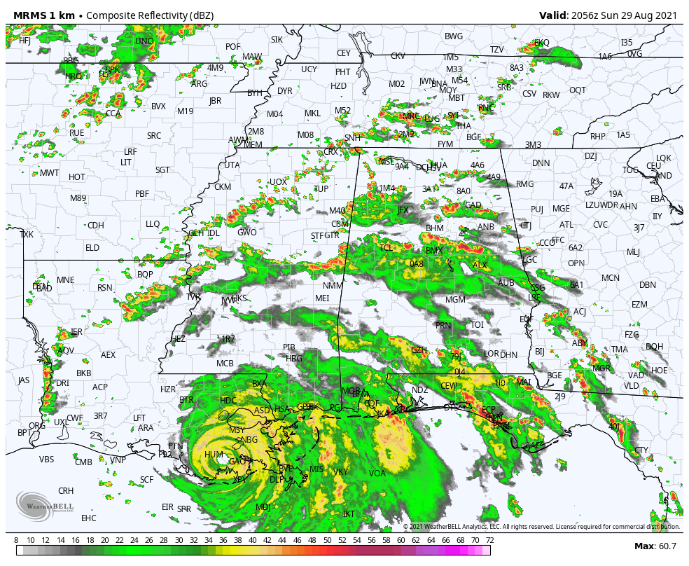
NWS Doppler radar imagery and data from an Air Force Reserve Hurricane Hunter aircraft showed that Ida made landfall around 1655 UTC along the southeastern coast of Louisiana near Port Fourchon with estimated maximum winds of 130 kt and a minimum pressure around 930 mb. Since that time, Ida made a second landfall southwest of Galliano, Louisiana, and with the eyewall now onshore, weakening has begun. Based on the latest Doppler velocities, the initial wind speed has been conservatively reduced to 115 kt for this advisory. As Ida’s circulation moves farther inland this evening and overnight, a faster rate of weakening is expected, and Ida is forecast to become a tropical depression over Mississippi by late Monday. Although weakening is forecast, damaging winds, especially in gusts, are expected to spread inland over southeastern Louisiana and southwestern Mississippi through Monday morning. To account for this, the gust factor in the Forecast/Advisory has been adjusted accordingly. By 72 hours, Ida is predicted to merge with a frontal zone over the eastern United States and become an extratropical low, and this low is forecast to strengthen into a gale center near Atlantic Canada by the end of the forecast period.
Radar fixes indicate that Ida’s forward motion has slowed, and the initial motion estimate is 325/9 kt. The hurricane should turn northward tonight around the western periphery of a deep-layer ridge near the southeastern United States coast. Ida is forecast to turn northeastward and recurve over the eastern United States as it enters the mid-latitude westerlies. The GFS is a bit faster in ejecting the post-tropical cyclone northeastward on days 3 through 5, and the NHC forecast follows a blend of the various consensus models and the GFS ensemble mean.
KEY MESSAGES
1. Extremely life-threatening storm surge inundation of 9 feet or greater above ground level will continue through early this evening along portions of the coast between Burns Point, Louisiana, to Ocean Springs, Mississippi. Overtopping of local levees outside of the Hurricane and Storm Damage Risk Reduction System is possible where local inundation values may be higher.
2. Catastrophic wind damage will occur near the core of Ida as it moves inland over southeastern Louisiana during the next few hours. Hurricane-force winds and damaging wind gusts are expected through tonight within the Hurricane Warning area in southeastern Louisiana, including metropolitan New Orleans.
3. Damaging winds, especially in gusts, will spread inland near the track of the center of Ida into southwestern Mississippi tonight and early Monday. These winds will likely lead to widespread tree damage and power outages.
4. Ida will continue to produce heavy rainfall through Monday across the central Gulf Coast across southeast Louisiana, coastal Mississippi, and southwestern Alabama, resulting in considerable to life-threatening flash and urban flooding and significant river flooding impacts. As Ida moves inland, significant flooding impacts are possible across portions of the Lower Mississippi Valley, Tennessee Valley, Upper Ohio Valley, Central Appalachians, and Mid-Atlantic through Wednesday.
HAZARDS TO LAND
STORM SURGE: The combination of a dangerous storm surge and the
tide will cause normally dry areas near the coast to be flooded by
rising waters moving inland from the shoreline. The water could
reach the following heights above ground somewhere in the indicated
areas if the peak surge occurs at the time of high tide…
* Port Fourchon, LA to Mouth of the Mississippi River…12-16 ft
* Morgan City, LA to Port Fourchon, LA…8-12 ft
* Mouth of the Mississippi River to Bay St. Louis, MS including Lake Borgne…8-12 ft
* Bay St. Louis, MS to Ocean Springs, MS…5-8 ft
* Lake Pontchartrain…5-8 ft
* Ocean Springs, MS to MS/AL border…4-7 ft
* Lake Maurepas…4-6 ft
* MS/AL border to AL/FL border including Mobile Bay…3-5 ft
* Intracoastal City, LA to Morgan City, LA including Vermilion Bay…1-3 ft
* AL/FL border to Okaloosa/Walton County Line including Pensacola Bay…1-3 ft
Overtopping of local levees outside of the Hurricane and Storm Damage Risk Reduction System is possible where local inundation values may be higher than those shown above.
The deepest water will occur along the immediate coast near and to the east of the landfall location, where the surge will be accompanied by large and dangerous waves. Surge-related flooding depends on the relative timing of the surge and the tidal cycle, and can vary greatly over short distances.
WIND: Catastrophic wind damage is likely near the core of Ida as it moves inland over southeastern Louisiana through this evening.
Hurricane conditions will spread farther inland within the Hurricane Warning area over southeastern Louisiana tonight. Tropical storm conditions will also spread inland over portions of Louisiana and Mississippi tonight and Monday.
RAINFALL: Heavy rainfall from Ida will continue to impact the southeast Louisiana coast, spreading northeast into the Lower Mississippi Valley this evening into Monday. Total rainfall
accumulations of 10 to 18 inches, with isolated maximum amounts of 24 inches, are possible across southeast Louisiana into far southern Mississippi through Monday. This is likely to result in life-
threatening flash and urban flooding and significant river flooding impacts.
Ida is forecast to turn to the northeast on Monday and track across the Middle Tennessee Valley and Upper Ohio Valley through Wednesday, producing the following rainfall totals:
Coastal Alabama to the far western Florida panhandle: 5 to 10 inches, with isolated maximum amounts of 15 inches, today through Tuesday morning.
Central Mississippi: 4 to 8 inches, with isolated maximum amounts of 12 inches, tonight through Monday night.
Middle Tennessee Valley, Upper Ohio Valley, Central Appalachians into the Mid-Atlantic: 3 to 6 inches with isolated higher amounts, Tuesday into Wednesday.
These rainfall totals will result in considerable flash flooding, along with widespread minor to isolated major riverine flooding from the Lower Mississippi Valley into far western Alabama.
TORNADOES: Tornadoes will be most likely through Monday over southeast Louisiana, southern Mississippi, southwest Alabama, and the western Florida Panhandle. A few tornadoes are also possible farther north across much of Mississippi and Alabama on Monday.
SURF: Swells will continue to affect the northern Gulf coast through early Monday. These swells are likely to cause life-threatening surf and rip current conditions.
All images, forecasts, and documents are courtesy of their respective publishers.
Category: Alabama's Weather, ALL POSTS, Severe Weather, Tropical
About the Author (Author Profile)
Scott Martin is an operational meteorologist, professional graphic artist, musician, husband, and father. Not only is Scott a member of the National Weather Association, but he is also the Central Alabama Chapter of the NWA president. Scott is also the co-founder of Racecast Weather, which provides forecasts for many racing series across the USA. He also supplies forecasts for the BassMaster Elite Series events including the BassMaster Classic.Subscribe
If you enjoyed this article, subscribe to receive more just like it.


