4 pm Advisory — Ida Weakens to a Depression; Heavy Rains & Flash Flooding Threat Continues
*** This is the last public advisory issued by the National Hurricane Center on Ida. ***
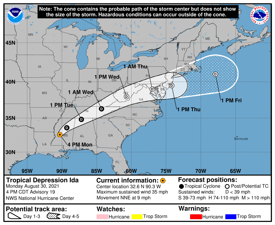
SUMMARY OF 400 PM CDT…2100 UTC…INFORMATION
———————————————-
LOCATION…32.6N 90.3W
ABOUT 20 MI…35 KM NNW OF JACKSON, MISSISSIPPI
MAXIMUM SUSTAINED WINDS…35 MPH…55 KM/H
PRESENT MOVEMENT…NNE OR 20 DEGREES AT 9 MPH…15 KM/H
MINIMUM CENTRAL PRESSURE…999 MB…29.50 INCHES
WATCHES AND WARNINGS
——————–
All Tropical Storm and Storm Surge Warnings have been discontinued.
DISCUSSION AND OUTLOOK
———————-
At 400 PM CDT (2100 UTC), the center of Tropical Depression Ida was located near latitude 32.6 North, longitude 90.3 West. The depression is moving toward the north-northeast near 9 mph (15 km/h). A faster northeastward motion is expected tonight through Wednesday. On the forecast track, the center of Ida will move farther inland over central and northeastern Mississippi tonight. Ida is then forecast to move across the Tennessee Valley on Tuesday and near the central Appalachians on Wednesday.
Maximum sustained winds have decreased to near 35 mph (55 km/h) with higher gusts. Additional weakening is forecast during the next day or so.
The minimum central pressure estimated from surface observations is 999 mb (29.50 inches).
HAZARDS AFFECTING LAND
———————-
STORM SURGE: Water levels along the northern Gulf coast should continue to subside through this evening.
RAINFALL: Through Tuesday morning across portions of southeast Louisiana into far southern Mississippi, Ida will produce additional rainfall totals of 2 to 4 inches, with localized higher amounts possible. Storm total rainfall accumulations of 10 to 18 inches, with isolated maximum amounts of 24 inches, is expected. Heavy rain combined with storm surge has resulted in catastrophic impacts along the southeast coast of Louisiana, with considerable flash flooding and riverine flooding continuing farther inland.
Ida will continue to turn northeast this evening and is forecast to track across the Middle Tennessee Valley, Ohio Valley and Mid-Atlantic through Wednesday, producing the following rainfall totals:
Coastal Alabama to the far western Florida panhandle: An additional 3 to 6 inches resulting in storm total accumulations of 6 to 12 inches with isolated maximum amounts of 15 inches, today through Tuesday morning.
Central Mississippi into far western Alabama: 4 to 8 inches, with isolated maximum amounts of 12 inches, today through tonight.
Middle Tennessee Valley, Ohio Valley, Central/Southern Appalachians into the Mid-Atlantic: 3 to 6 inches with isolated higher amounts, Tuesday into Wednesday.
Southern New England: 2 to 4 inches, with isolated higher amounts, Wednesday into Thursday.
Considerable flash flooding is possible from the Lower Mississippi Valley through the Middle Tennessee Valley, Ohio Valley, Central/Southern Appalachians, and into the Mid-Atlantic. Widespread minor to isolated major riverine flooding is occurring or forecast from the Lower Mississippi Valley into far western Alabama. Rivers will remain elevated into next week.
TORNADOES: A few tornadoes are possible through tonight, mainly across far southeast Mississippi, the southern half of Alabama, and the western Florida Panhandle. The threat for a few tornadoes will shift east on Tuesday and become centered across eastern Alabama, western Georgia, and the Florida Panhandle.
SURF: Swells will continue to affect portions of the northern Gulf Coast through this evening. These swells are likely to cause life-threatening surf and rip current conditions.
Category: Alabama's Weather, ALL POSTS, Severe Weather, Tropical
About the Author (Author Profile)
Scott Martin is an operational meteorologist, professional graphic artist, musician, husband, and father. Not only is Scott a member of the National Weather Association, but he is also the Central Alabama Chapter of the NWA president. Scott is also the co-founder of Racecast Weather, which provides forecasts for many racing series across the USA. He also supplies forecasts for the BassMaster Elite Series events including the BassMaster Classic.Subscribe
If you enjoyed this article, subscribe to receive more just like it.


