A Few Tornadoes Remain Possible Across the West & Southwestern Parts of Central Alabama
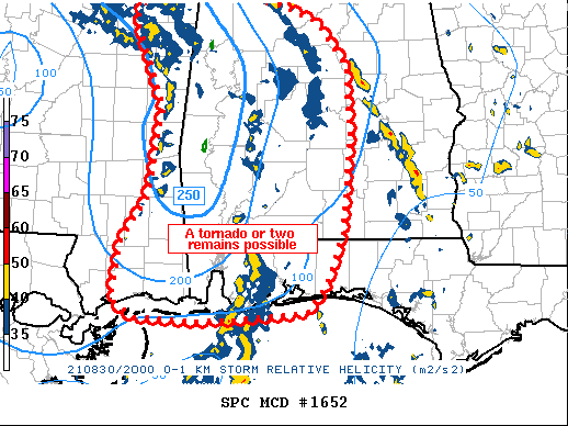
The risk for a few tropical-induced tornadoes remain across the west and southwestern parts of Central Alabama as we are moving into the late afternoon hours. The Storm Prediction Center has outlined an area that is where the potential is highest for those tornadoes. Here is the text from the latest Mesoscale Discussion from the SPC:
Mesoscale Discussion 1652
NWS Storm Prediction Center Norman OK
0313 PM CDT Mon Aug 30 2021
Areas affected…eastern Mississippi into Alabama…western Florida
Panhandle
Concerning…Tornado Watch 475…
Valid 302013Z – 302215Z
The severe weather threat for Tornado Watch 475 continues.
SUMMARY…Conditions remain sufficiently favorable for a tornado
risk in association with Ida. The primary risk area appears to be
from eastern Mississippi into western Alabama.
DISCUSSION…Three primary bands of convection persist from MS into
AL and the FL Panhandle this afternoon. The middle band has been the
most productive in terms of tornado risk, but has lost intensity
with time as it translated east into central AL. Widespread rain is
likely limited potential here.
To the east, scattered storms persist across southeast AL and into
the FL Panhandle. Here, instability is maximized, but this area is
on the eastern fringe of the more favorable shear. As such, the
tornado risk here may remain low.
In the near term, the most favorable area may be with a newly
developed band consisting of broken cells over far eastern MS. The
environment here consists of 250+ 0-1 km SRH, as well as a narrow
sector of recovering air mass out of the southwest. This may yield a
tornado risk which may shift again into parts of AL.
Category: Alabama's Weather, ALL POSTS, Severe Weather, Tropical
About the Author (Author Profile)
Scott Martin is an operational meteorologist, professional graphic artist, musician, husband, and father. Not only is Scott a member of the National Weather Association, but he is also the Central Alabama Chapter of the NWA president. Scott is also the co-founder of Racecast Weather, which provides forecasts for many racing series across the USA. He also supplies forecasts for the BassMaster Elite Series events including the BassMaster Classic.Subscribe
If you enjoyed this article, subscribe to receive more just like it.


