Midday Nowcast: Lower Humidity Levels Settling into Alabama

A surge of dry air is settling into the state today as our dew points fall, meaning lower humidity. We are seeing see ample sunshine and highs this afternoon are in the mid to upper 80s, with a nice north wind. Tonight will be clear and very pleasant…most places will drop well down into the 60s, but some of the cooler spots across North Alabama could reach the upper 50s.
TOMORROW THROUGH LABOR DAY: Really nice early September weather highlights our forecast with sunny and warm weather, and fair, pleasant nights. Highs will be in the upper 80s for most location, while lows will be well down in the 60s. Sunday looks mostly dry with a partly to mostly sunny sky, but a few showers could creep into North Alabama late in the day and push south through the state Sunday night as a weak disturbance approaches from the north. The high Sunday afternoon will remain generally in the upper 80s. For Labor Day Monday, expect a mix of sun and clouds with a few scattered showers possible statewide as moisture levels rise a bit. Nothing widespread, nothing too heavy. And, once again temperatures will reach the upper 80s Monday afternoon.
REST OF NEXT WEEK: We will keep some risk of scattered showers in the forecast Tuesday and Wednesday, but both days should still feature a decent amount of sun. And, the risk of a shower Thursday and Friday looks low at this point. Highs through the week will remain at seasonal averages, in the upper 80s
IN THE TROPICS: A small area of low pressure over northeastern Nicaragua is producing disorganized shower and thunderstorm activity. A portion of the low’s circulation could move over the Gulf of Honduras on Friday. However, development there, if any, is expected to be slow to occur. This system could then move over the southwestern Gulf of Mexico during the weekend and early next week, but by then strong upper-level winds would likely limit significant development. Regardless of development, heavy rains are possible across portions of Central America and the Yucatan Peninsula through the weekend. Formation chance through 5 days…low…20 percent. If it does develop and is named, it would be Mindy.
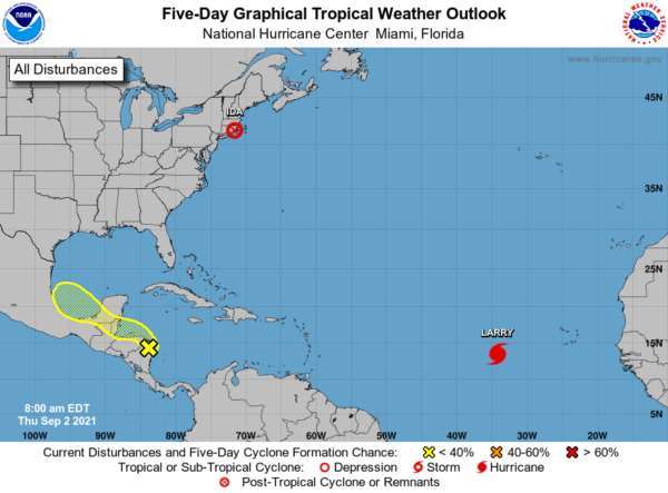
HURRICANE LARRY: The center of Hurricane Larry was located near latitude 13.5 North, longitude 34.2 West. Larry is moving toward the west near 17 mph. A gradual turn towards the west-northwest with a decrease in forward speed are expected over the next few days.
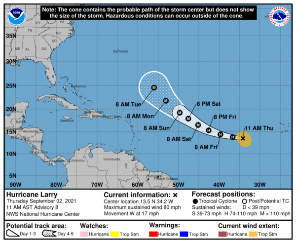
Maximum sustained winds have increased to near 80 mph with higher gusts. Steady to rapid strengthening is forecast during the next couple of days, and Larry is expected to become a a major hurricane by Friday night. Hurricane-force winds extend outward up to 15 miles from the center. Recent satellite wind data indicates that the tropical-storm-force wind radii are expanding and now extend outward up to 160 miles. The estimated minimum central pressure is 985 mb (29.09 inches).
BEACH FORECAST CENTER: Get the latest weather and rip current forecasts for the beaches from Fort Morgan to Panama City on our Beach Forecast Center page. There, you can select the forecast of the region that you are interested in visiting.
WORLD TEMPERATURE EXTREMES: Over the last 24 hours, the highest observation outside the U.S. was 124.0F at Bordji B. Mokhtar, Algeria. The lowest observation was -95.6F at Nico, Antarctica.
CONTIGUOUS TEMPERATURE EXTREMES: Over the last 24 hours, the highest observation was 109F at Death Valley, CA. The lowest observation was 20F at Choteau, MT.
Category: Alabama's Weather, ALL POSTS
About the Author (Author Profile)
Macon, Georgia Television Chief Meteorologist, Birmingham native, and long time Contributor on AlabamaWX. Stormchaser. I did not choose Weather, it chose Me. College Football Fanatic. @Ryan_StinnetSubscribe
If you enjoyed this article, subscribe to receive more just like it.


