

Sunday Weather Xtreme Video: Talking Tropics…Again
Tomorrow is the anniversary of the hottest day ever observed in Alabama history. It was 106F on September 5, 1925 in Birmingham, and the afternoon Birmingham News proclaimed that the Magic City was the hottest weather station in the country. But down the road in Centreville the next day, the mercury would peak at 112F. That would be the hottest reading in the state on that very hot day, and the hottest reading ever observed in Alabama. The 106F readings on the 5th and 6th are not the hottest days in Birmingham history. They were until that time, but on July 29, 1930, the mercury hit 107F in Birmingham.
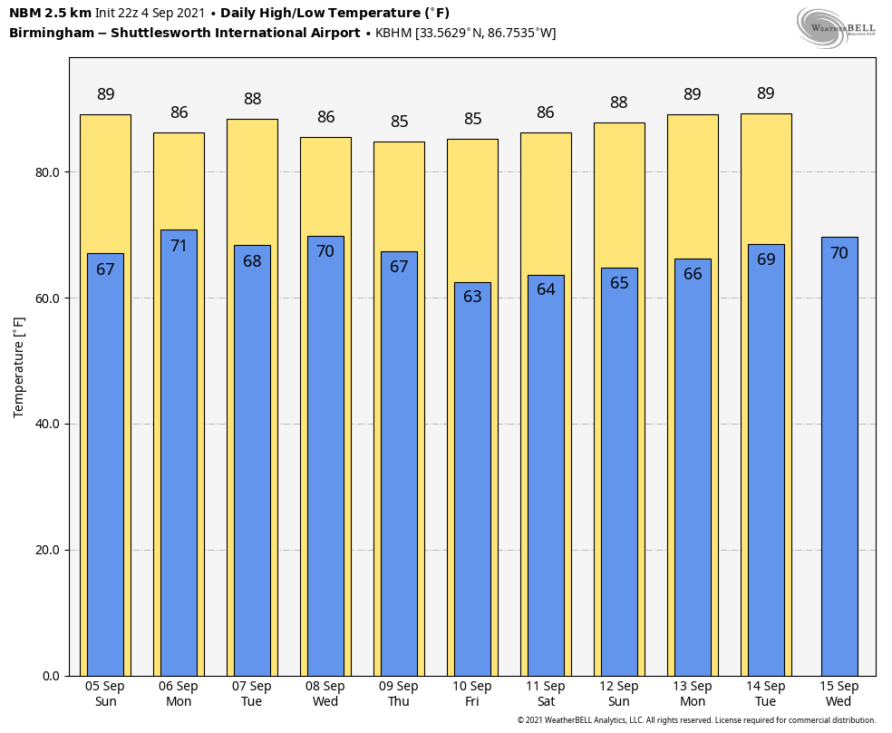
NO EXTREME HEAT IN OUR FUTURE: Just late-season warmth over the next 7-10 days in Alabama. A couple of cold fronts will give us lower humidities and more comfortable nighttime lows by the end of the week and the weekend. Before that, we will deal with a cool front and a potential tropical system in the Gulf of Mexico. Let’s dig into the details.
STARTING WITH YOUR SUNDAY: After a sunny Saturday, clouds will be increasing later today across the area as a cool front works its way into Alabama. Highs will be in the middle and upper 80s across the area today. Showers and storms will approach the northwestern corner of the state by late morning, and this activity will affect northwestern sections through the afternoon and into the evening. The activity should remain north of I-20. Overnight lows will be in the middle and upper 60s.
LABOR DAY: By Monday, the cool front will have settled down into the I-20 Corridor. Showers and thunderstorms will fire again during the day near the front. Highs on Monday will range from the lower 80s north to upper 89s and a couple of 90s South. The showers will linger into Monday evening, with lows in the 70-degree range. Showers and storms will bubble up on Tuesday near the stalled front over Central Alabama.
EYES ON THE GULF: Invest 91L emerged into the southwestern Gulf of Mexico yesterday and it is something we will have to keep an eye on. It should move northwest and north over the next 36 hours, and there is a chance that it could develop into a tropical or hybrid storm by mid-week. It looks like it eventually could move toward the middle Gulf Coast and affect areas from southeastern Louisiana, across the Mississippi, Alabama, and Northwest Florida coast. Its impacts will be mainly rain, which will begin increasing along the Gulf Coast
MIDWEEK: The stalled front should start to interact with the approaching low to the south on Wednesday, with mostly cloudy skies and scattered to numerous showers and storms. The front should start pushing south by Thursday, reacting to a growing upper-level trough to our north. The Gulf system should also react to the trough and begin moving northeast. It will spend the day and the evening on Thursday tracking eastward along the border between Alabama and Northwest Florida. North and Central Alabama will be enjoying some drier air behind the front, with highs in the middle 80s and lows in the middle 60s.
THE WEEKEND: Friday, Saturday, and Sunday will be mostly sunny, a little cooler, and less humid. Highs will be in the middle 80s mostly, with lows in the lower 60s. Those readings will be just a tad cooler than the normal highs and lows of 87F and 67F.
VOODOO TERRITORY: It appears the week two forecast period will be spent watching for another Gulf tropical storm or hurricane to decide which way It will go. Recent runs of our global models seem to be pointing toward a middle Gulf Coast landfall, perhaps in Louisiana.
ELSEWHERE IN THE TROPICS: Major Hurricane Larry is about 1,300 miles southeast of Bermuda this morning, but Bermudans are already eyeing the storm from their island nation perch in the western Atlantic. No stranger to hurricanes, the country is well prepared for storms. But a major Category 3 would be a test. Top winds are approaching 140 mph this morning and could reach 150 mph today or Monday. Those max winds will still be around 115 mph when Larry comes calling on Bermuda around Wednesday night or Thursday. In addition to the significant hurricane threat to Bermuda around Wednesday night and Thursday, it is likely that Larry will produce very large ocean swells that will reach the Lesser Antilles on Sunday and then spread westward through the Greater Antilles, the Bahamas, and Bermuda on Monday and Tuesday. These large ocean swells will lead to very high surf conditions and a significant threat for rip currents.
Beyond this, large ocean swells from Larry will reach much of the East Coast of the United States by about the middle part of next week leading to a significant threat for rip currents and high surf conditions.
BEACHCAST: Beautiful through Tuesday along the gorgeous beaches of Alabama and Northwest Florida, but rain and storms will be plentiful Wednesday and Thursday before the tropical system moves out, leaving nice weather for the weekend.
Click here to see the Beach Forecast Center page.
DANCING WITH THE STATS: Record lows Saturday morning over southeastern Georgia and northeastern Florida. 66F at Jacksonville was a record low for the date. The 54F at Augusta and the 62F at Savannah were records for the date as well.
ADVERTISE WITH US: Deliver your message to a highly engaged audience by advertising on the AlabamaWX.com website. The site enjoyed 17.2 MILLION page views in the past 12 months. Don’t miss out! We can customize a creative, flexible, and affordable package that will suit your organization’s needs. Contact me, Bill Murray, at (205) 687-0782, and let’s talk.
WEATHERBRAINS: This week, the panel will entertain. Check out the show at www.WeatherBrains.com. You can also subscribe on iTunes. You can watch the show live at live.bigbrainsmedia.com or on James’ YouTube Channel You will be able to see the show on the James Spann 24×7 weather channel on cable or directly over the air on the dot 2 feed.
ON THIS DATE IN 2003: Hurricane Fabian slammed into Bermuda with sustained winds of 120 mph. The Category Three hurricane was the strongest to strike Bermuda since 1953’s Edna, which brought 115 mph winds to the island. Four people were missing and presumed drowned after their cars were blown off of a causeway. Follow my weather history tweets on Twitter. I am @wxhistorian at Twitter.com.
Category: Alabama's Weather, ALL POSTS, Tropical
About the Author (Author Profile)
Bill Murray is the President of The Weather Factory. He is the site's official weather historian and a weekend forecaster. He also anchors the site's severe weather coverage. Bill Murray is the proud holder of National Weather Association Digital Seal #0001 @wxhistorianSubscribe
If you enjoyed this article, subscribe to receive more just like it.


