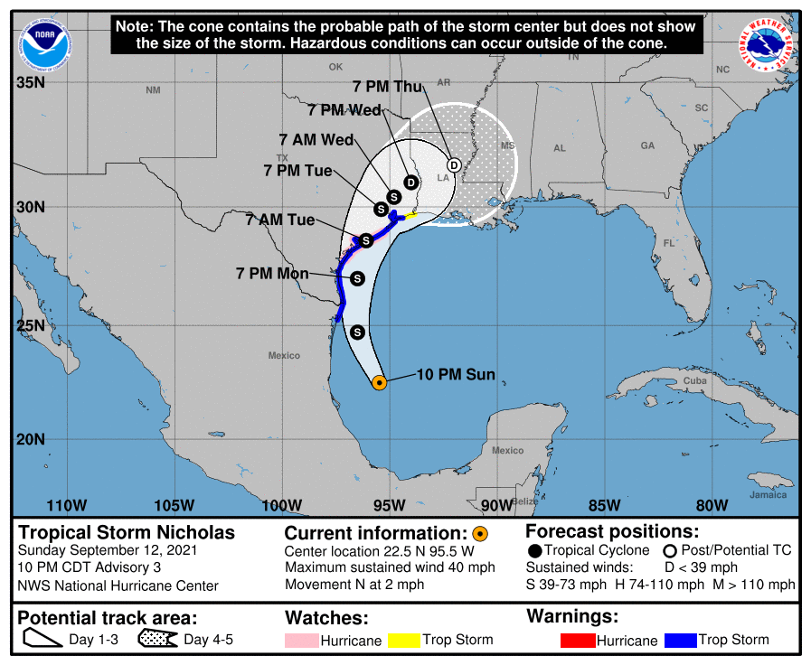
TS Nicholas: Watches & Warnings Have Been Extended Northeastward as of the 10 pm Advisory
SUMMARY OF 1000 PM CDT…0300 UTC…INFORMATION
———————————————–
LOCATION…22.5N 95.5W
ABOUT 170 MI…275 KM ESE OF LA PESCA, MEXICO
ABOUT 260 MI…415 KM SSE OF MOUTH OF THE RIO GRANDE
MAXIMUM SUSTAINED WINDS…40 MPH…65 KM/H
PRESENT MOVEMENT…N OR 360 DEGREES AT 2 MPH…4 KM/H
MINIMUM CENTRAL PRESSURE…1007 MB…29.74 INCHES
WATCHES AND WARNINGS
——————–
A Storm Surge Warning is in effect for…
* Port Aransas to San Luis Pass, Texas
* Aransas Bay, San Antonio Bay, and Matagorda Bay
A Hurricane Watch is in effect for…
* Port Aransas to Freeport, Texas
A Tropical Storm Warning is in effect for…
* Mouth of the Rio Grande to High Island, Texas
* Barra el Mezquital to the U.S./Mexico border
A Storm Surge Watch is in effect for…
* Mouth of the Rio Grande to Port Aransas Texas
* San Luis Pass, Texas, to Rutherford Beach, Louisiana, including Galveston Bay
* Baffin Bay and Corpus Christi Bay
A Tropical Storm Watch is in effect for…
* East of High Island, Texas to Sabine Pass
DISCUSSION AND OUTLOOK
———————-
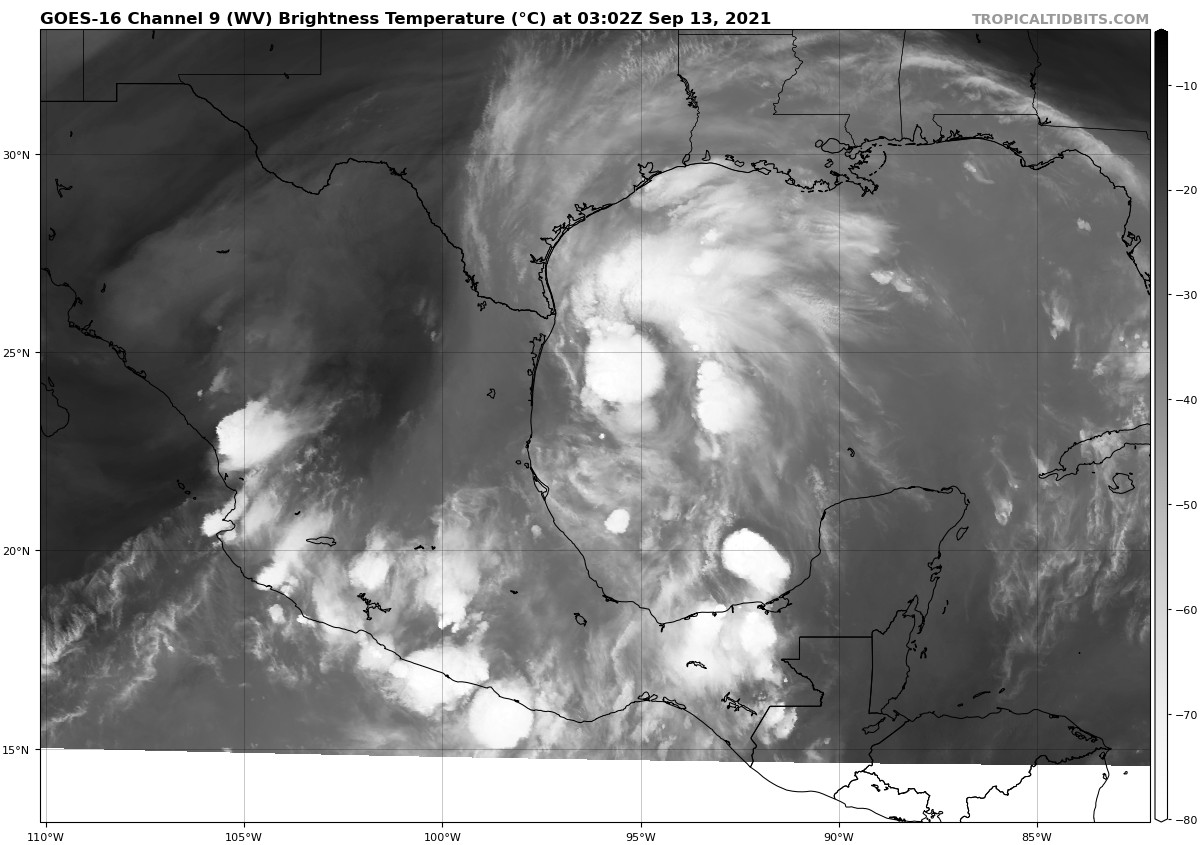
At 1000 PM CDT (0300 UTC), the center of Tropical Storm Nicholas was located near latitude 22.5 North, longitude 95.5 West. Nicholas has been meandering or drifting northward near 2 mph (4 km/h) over the past couple of hours, but a north-northwestward motion near 12 mph (19 km/h) is expected to resume by early Monday. A northward or north-northeastward motion is forecast by late Monday or Monday night. On the forecast track, the center of Nicholas will pass near or just offshore the coasts of northeastern Mexico and South Texas on Monday, and move onshore along the coast of south or central Texas coast Monday night or early Tuesday.
Maximum sustained winds are near 40 mph (65 km/h) with higher gusts. Strengthening is forecast until Nicholas reaches the northwest Gulf coast Monday night or early Tuesday.
Tropical-storm-force winds extend outward up to 115 miles (185 km) from the center.
The estimated minimum central pressure is 1007 mb (29.74 inches).
KEY MESSAGES
———————-
1. Periods of heavy rainfall are expected to impact portions of the Texas and Louisiana coasts through the middle of the week. Significant rainfall amounts are possible, potentially resulting in areas of considerable flash and urban flooding, especially in highly urbanized metropolitan areas. Isolated minor to moderate river flooding is also expected.
2. There is the danger of life-threatening storm surge inundation along the coast of Texas from Port Aransas to San Luis Pass. Residents in these areas should follow any advice given by local officials.
3. Nicholas is forecast to approach the middle Texas coast as a strong tropical storm late Monday and early Tuesday, and could be near hurricane intensity if it moves to the right of the forecast track and remains over water longer. Tropical storm conditions are expected along portions of the middle Texas coast beginning Monday afternoon, with hurricane conditions possible from Port Aransas to Freeport late Monday and Monday night.
4. Tropical storm conditions are expected along portions of the northeastern coast of Mexico and the coast of south Texas beginning Monday morning.
HAZARDS AFFECTING LAND
———————-
RAINFALL: Nicholas is expected to produce storm total rainfall of 8 to 16 inches, with isolated maximum amounts of 20 inches, across portions of the middle and upper Texas coastal areas tonight through the middle of the week. Across the rest of coastal Texas into southwest Louisiana, rainfall of 5 to 10 inches is expected. This rainfall may produce areas of considerable flash and urban flooding, especially in highly urbanized metropolitan areas. Additionally, there is the potential for isolated minor to moderate river flooding.
Over the northeastern portions of the Mexican state of Tamaulipas, rainfall amounts of 2 to 5 inches can be expected tonight into Monday.
STORM SURGE: The combination of a dangerous storm surge and the tide will cause normally dry areas near the coast to be flooded by rising waters moving inland from the shoreline. The water could reach the following heights above ground somewhere in the indicated areas if the peak surge occurs at the time of high tide…
Port O’Connor to San Luis Pass, TX including Matagorda Bay… 3-5 ft
San Luis Pass, TX to Rutherford Beach, LA including Galveston Bay…2-4 ft
Mouth of the Rio Grande to Port O’Connor, TX…2-4 ft
Baffin Bay, Corpus Christi Bay, Aransas Bay and San Antonio Bay…2-4 ft
Rutherford Beach, LA to Intracoastal City, LA…1-3 ft
Sabine Lake and Calcasieu Lake…1-3 ft
The deepest water will occur along the immediate coast in areas of onshore winds, where the surge will be accompanied by large and dangerous waves. Surge-related flooding depends on the relative timing of the surge and the tidal cycle, and can vary greatly over short distances. For information specific to your area, please see products issued by your local National Weather Service forecast office.
WIND: Tropical storm conditions are expected to first reach the coast within the warning area in northeastern Mexico and southern Texas Monday morning, making outside preparations difficult or dangerous. These conditions will spread northward within the warning area through Monday night. Hurricane conditions are possible in the Hurricane Watch area Monday night. Tropical storm conditions are possible within the watch area by late Monday night or early Tuesday.
TORNADOES: A tornado or two will be possible Monday into Monday night across the middle and lower Texas coast.
SURF: Swells generated by Nicholas will begin affecting portions of the northwest Gulf coast tonight and continue into Tuesday. These swells are likely to cause life-threatening surf and rip current conditions. Please consult products from your local weather office.
Category: ALL POSTS, Severe Weather, Tropical
About the Author (Author Profile)
Scott Martin is an operational meteorologist, professional graphic artist, musician, husband, and father. Not only is Scott a member of the National Weather Association, but he is also the Central Alabama Chapter of the NWA president. Scott is also the co-founder of Racecast Weather, which provides forecasts for many racing series across the USA. He also supplies forecasts for the BassMaster Elite Series events including the BassMaster Classic.Subscribe
If you enjoyed this article, subscribe to receive more just like it.


