Midday Nowcast: Continued Cloudy with Scattered Showers
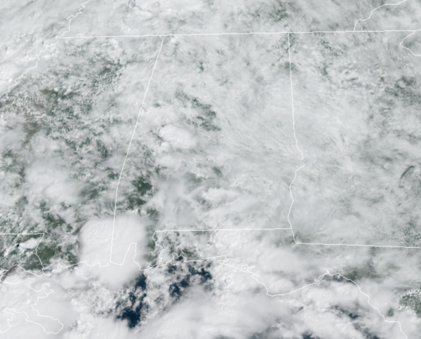
The tropical air mass remains in place, so it remains mainly cloudy with scattered to numerous showers remaining in the forecast today, tomorrow, and Sunday. Rain is possible at anytime, but the greatest coverage will occur during the afternoon and evening hours. Of course, there will be some decent breaks in the rain, and there will be some peeks of sunshine along the way, but for the most part the clouds and rain will win the forecast.

Now the the weekend won’t be a “wash-out”, but if you have something planned outside just know some rain is likely occasionally, keep an eye on radar trends. Highs through Sunday should be range from the upper 70s to lower 80s.
FOOTBALL NIGHT LIGHTS: For the high school games tonight, the sky will be mostly cloudy, showers are very possible, so take the rain gear (but it won’t rain at every stadium). Temperatures will fall slowly through 70s during the games.
COLLEGE FOOTBALL FORECAST: ALABAMA AT FLORIDA (2:30p CT kickoff): It will be a warm, humid day in Gainesville tomorrow. A few passing showers and thunderstorms are likely during the game (take the rain gear)… temperatures will fall from near 84 at kickoff, into the low 80s by the fourth quarter.
AUBURN AT PENN STATE (6:30p CT kickoff): A passing shower can’t be ruled out during the game in State College (especially the first quarter), otherwise mostly fair with temperatures falling from around 80 at kickoff, into the low 70s by the final whistle.
UAB AT NORTH TEXAS (6:30p CT kickoff): The sky will be clear in Denton, Texas Saturday evening. Temperatures will fall from around 90 degrees at kickoff, to near 80 by the fourth quarter.
NORTH ALABAMA AT JACKSONVILLE STATE (6:00p CT kickoff): It will be a warm, humid Saturday night; a shower or storm can’t be ruled out. Temperatures will fall from near 79 at kickoff, into the mid 70s by the final whistle.
TROY AT SOUTHERN MISS (6:00p CT kickoff): A few showers are likely during the first half of the game, otherwise it will be a warm, humid night in Hattiesburg with temperatures falling from the low 80s into the upper 70s.
NEXT WEEK: The pattern doesn’t change much for Monday and Tuesday as moist air remains in place and therefor we should continue to see more clouds than sun, with scattered showers and thunderstorms on a daily basis. Highs should be in the low to mid 80s, which is pretty close to where they should be this time of year. By late Wednesday and into Thursday, the global models are showing a strong front finally sweeping through the state, bringing a much drier air mass back to the state.
IN THE TROPICS: Three features the NHC is monitoring, two of which could become Odette and Peter in the coming days.
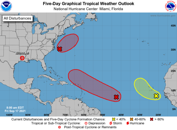
1. Showers and thunderstorms remain disorganized in association with a tropical wave and broad area of low pressure located about midway between the Lesser Antilles and the Cabo Verde Islands. However, environmental conditions are expected to be conducive for development during the next few days, and a tropical depression is still likely to form over the weekend or early next week while moving toward the west-northwest at 15 to 20 mph across the central tropical Atlantic and then near or north of the Leeward Islands by Monday and Tuesday. Interests in the Leeward Islands should monitor the progress of this system during the next few days. Formation chance through 5 days…high…70 percent.
2. The circulation associated with an area of low pressure located about 150 miles east of Cape Hatteras, North Carolina, remains broad and elongated, and most of the associated shower and thunderstorm activity is displaced well to the north and east of the center. However, this system is still likely to become a short-lived tropical depression or tropical storm before it makes a transition to a non-tropical gale-force low by Saturday or Saturday night while moving northeastward at about 15 mph away from the United States mid-Atlantic and Northeast coasts. Formation chance through 5 days…high…70 percent.
3. Disorganized cloudiness and thunderstorms over the far eastern tropical Atlantic are associated with a tropical wave located a couple of hundred miles southeast of the Cabo Verde Islands. Environmental conditions are forecast to be only marginally conducive, and development, if any, of this system should be slow to occur over the next few days while the system moves toward the west-northwest or northwest at 5 to 10 mph over the far eastern Atlantic. Formation chance through 5 days…low…20 percent.
BEACH FORECAST CENTER: Get the latest weather and rip current forecasts for the beaches from Fort Morgan to Panama City on our Beach Forecast Center page. There, you can select the forecast of the region that you are interested in visiting.
WORLD TEMPERATURE EXTREMES: Over the last 24 hours, the highest observation outside the U.S. was 114.1F at In-Salah, Algeria. The lowest observation was -94.0F at Amundsen-Scott South Pole Station, Antarctica.
CONTIGUOUS TEMPERATURE EXTREMES: Over the last 24 hours, the highest observation was 109F at Ocotillo Wells, CA. The lowest observation was 23F at Stanley, ID and Peter Sinks, UT.
Category: Alabama's Weather, ALL POSTS
About the Author (Author Profile)
Macon, Georgia Television Chief Meteorologist, Birmingham native, and long time Contributor on AlabamaWX. Stormchaser. I did not choose Weather, it chose Me. College Football Fanatic. @Ryan_StinnetSubscribe
If you enjoyed this article, subscribe to receive more just like it.


