Midday Update: Rain, Rain, Rain, and More Rain
The tropical air mass in place continues to produce a cloudy sky and wet conditions across much of Alabama. We have been dealing with very heavy rainfall across the area already this morning, and the radar continues to only get more active as we head into the afternoon. Flash flooding is a concern as well and remember to turn around, don’t drown if you encounter floodwaters. The flash flood warning continues for Jefferson and Shelby Counties.
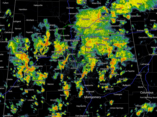
Additional flash flood warnings are very likely as we the rain and storms will continue through the afternoon and evening hours, and should begin to wind down some overnight. The clouds and rain are keeping temperatures in the upper 70s and lower 80s today.
FOR TOMORROW: Unfortunately, the weather will not change tomorrow. It will be another cloudy day with widespread and numerous showers and storms, and some will produce more tropical downpours. Highs tomorrow will be in the upper 70s and lower 80s.
THE WEEK AHEAD: The wet pattern persist Monday and Tuesday as moist air remains in place. Therefore, we will continue to see more clouds than sun, with numerous showers and thunderstorms both days. Highs should be in the low 80s. On Wednesday a potent front will swing through the state, finally clearing out all this tropical air and bring a much drier air mass back to Alabama. For Thursday and Friday, expect sunshine in fully supply, lower humidity and highs in the mid-70s; lows will be in the 50s.
IN THE TROPICS: Tropical Storm Odette formed late yesterday and continues to pull away from the U.S. Coast. The center of Tropical Storm Odette was located near latitude 38.5 North, longitude 67.3 West. Odette is moving toward the northeast near 17 mph. A turn toward the east-northeast at a faster forward speed is expected by this evening. Odette should then slow down and turn toward the east and southeast on Monday and Tuesday. On the forecast track, the center of Odette will pass south of Atlantic Canada Sunday and Monday.
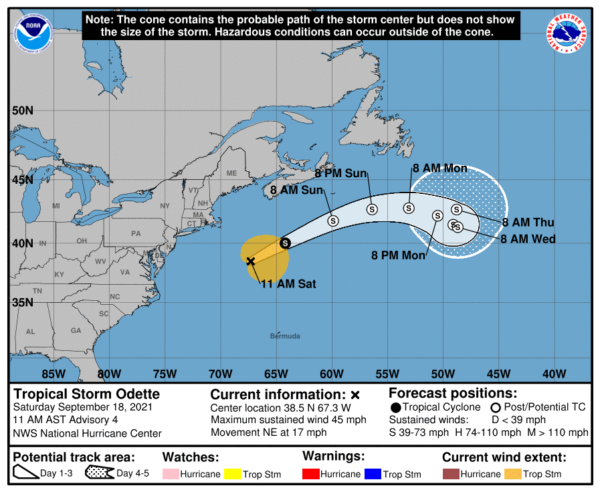
Maximum sustained winds are near 45 mph with higher gusts. Strengthening is forecast during the next day or two, and Odette is expected to become a strong post-tropical low by tonight. Tropical-storm-force winds extend outward up to 195 miles from the center. The estimated minimum central pressure is 1002 mb (29.59 inches).
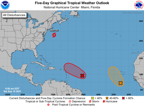
Elsewhere in the tropics, showers and thunderstorms continue to become better organized in association with an area of low pressure located about 650 miles miles east-southeast of the northern Leeward Islands. Environmental conditions are expected to be conducive for further development during the next day or two, and a tropical depression or tropical storm is expected to form later today or tonight while the system moves toward the west-northwest at about 15 mph. This system is expected to be near the northern Leeward Islands on Monday and Tuesday, and interests there should monitor its progress. Upper-level winds are likely to become less conducive for development when the system reaches the southwestern Atlantic by the early to middle part of next week. Formation chance through 48 hours…high…90 percent.
Also, a broad area of low pressure is located over the far eastern Atlantic a few hundred miles south of the Cabo Verde Islands. The associated shower and thunderstorm activity has become a little better organized since yesterday, and environmental conditions appear conducive for further development during the next couple of days. A tropical depression could form while the system moves northwestward at about 10 mph to the west of the Cabo Verde Islands before it reaches cooler waters and stronger upper-level winds early next week. Formation chance through 5 days…medium…40 percent.
BEACH FORECAST CENTER: Get the latest weather and rip current forecasts for the beaches from Fort Morgan to Panama City on our Beach Forecast Center page. There, you can select the forecast of the region that you are interested in visiting.
WORLD TEMPERATURE EXTREMES: Over the last 24 hours, the highest observation outside the U.S. was 115.7F at Abadan, Iran. The lowest observation was -89.7F at Concordia, Antarctica.
CONTIGUOUS TEMPERATURE EXTREMES: Over the last 24 hours, the highest observation was 106F at Death Valley, CA and Rio Grande Village, TX. The lowest observation was 22F at Peter Sinks, UT.
WEATHER ON THIS DATE IN 1926: The great “”Miami Hurricane”” produced winds reaching 138 mph which drove ocean waters into the Biscayne Bay drowning 135 persons. The eye of the hurricane passed over Miami, at which time the barometric pressure reached 27.61 inches. Tides up to twelve feet high accompanied the hurricane, which claimed a total of 372 lives.
Category: Alabama's Weather, ALL POSTS
About the Author (Author Profile)
Macon, Georgia Television Chief Meteorologist, Birmingham native, and long time Contributor on AlabamaWX. Stormchaser. I did not choose Weather, it chose Me. College Football Fanatic. @Ryan_StinnetSubscribe
If you enjoyed this article, subscribe to receive more just like it.


