Midday Nowcast: Fall Air Mass Arriving
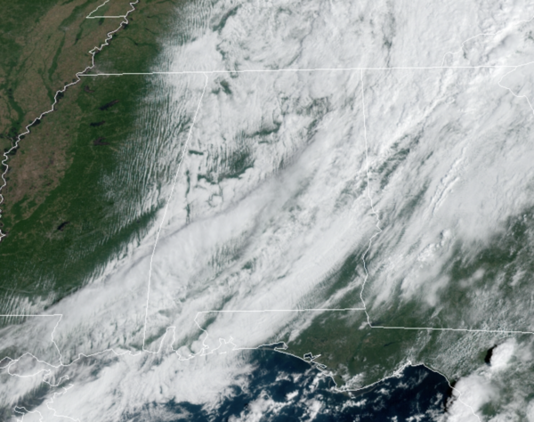
Wow, what a difference a front makes…The strong cold front moved through the area and is delivering our first true taste of fall this year, quite fitting that today is the first official day of fall which officially arrives at 2:21 PM CDT. Behind the front, we are dealing with a brisk northerly wind, which is driving in the much drier and cooler air mass into the state. Dew points are falling fast, and the sky will be clearing from northwest to southeast through the afternoon hours, and we should be mostly sunny by the end of the day. The sky is mostly clear over northern Mississippi already. Highs this afternoon will be in the low to mid 70s for most locations.
TONIGHT: Expect a clear and very cool night as temperatures fall well down into the 50s for most of North/Central Alabama, and there could be a few 40s in spots.
FANTASTIC FALL WEATHER: For tomorrow and Friday, expect picture perfect fall weather for Alabama. Abundant sunshine, lower humidity, and afternoon temperatures in the low to mid-70s. Friday morning will be the coolest and will be almost cold as many spots across North and Central Alabama are likely to make it into the upper 40s, light jackets will certainly be needed.
WONDERFUL WEEKEND WEATHER: The phenomenal fall weather will continue into the weekend. Temperatures will moderate a tad, but still humidity levels will be low and overall the weather will be clear and sunny. Highs both days will be in the upper 70s to lower 80s, while nights will remain refreshing, in the 50s.
FOOTBALL WEATHER: Perfect weather for the high school games across Alabama tomorrow and Friday; clear and cool with temperatures falling through the 60s.
GEORGIA STATE AT AUBURN (3p CT kickoff at Jordan-Hare Stadium): A clear sky with temperatures falling from near 80 degrees at kickoff into the low 70s by the final whistle.
SOUTHERN MISS AT ALABAMA (6:30p CT kickoff at Bryant-Denny Stadium): Clear and very pleasant. Kickoff temperature near 78 degrees, falling into the upper 60s by the fourth quarter.
UAB AT TULANE (7p CT kickoff at Yulman Stadium in New Orleans): A clear sky with temperatures falling from 77 degrees at kickoff to near 70 by the final whistle.
UT-MARTIN AT JACKSONVILLE STATE (3p CT kickoff at Burgess-Snow Field): A beautiful day; the sky will be clear with temperatures falling from 79 degrees at kickoff to near 70 by the end of the game.
TROY AT LA-MONROE (7p CT kickoff at Monroe, LA): The sky will be clear with temperatures falling from near 80 at kickoff, into the upper 60s by the final whistle.
INTO NEXT WEEK: Dry weather continues Monday through Wednesday with highs in the low 80s… global models suggest a few showers could return by Thursday and Friday as moisture levels rise, but amounts will likely be light.
IN THE TROPICS: The National Hurricane Center is issuing advisories on Tropical Depression Peter, located a few hundred miles north of Puerto Rico, and on Tropical Depression Rose, located about 1000 miles west-northwest of the Cabo Verde Islands.
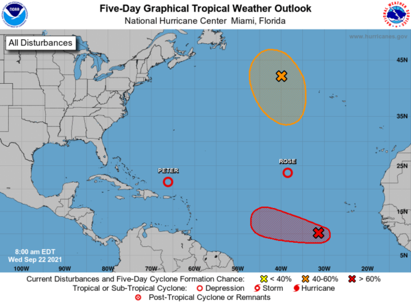
1. Showers and thunderstorms continue to become better organized in association with a tropical wave located several hundred miles southwest of the Cabo Verde Islands. Environmental conditions are expected to remain conducive for additional development, and a tropical depression is expected to form within a day or two while the system moves westward at 10 to 15 mph across the eastern and central tropical Atlantic Ocean. Formation chance through 48 hours…high…90 percent.
2. A gale-force, non-tropical low pressure system, the remnants of Odette, is located a little less than 500 miles west-northwest of the westernmost Azores. This low could acquire some subtropical characteristics over marginally warm waters during the next few days while it makes a counter-clockwise loop over the north-central Atlantic Ocean. However, by the weekend, this system is expected to move into an environment of strong upper-level winds. Formation chance through 48 hours…low…30 percent. Formation chance through 5 days…medium…50 percent.
BEACH FORECAST CENTER: Get the latest weather and rip current forecasts for the beaches from Fort Morgan to Panama City on our Beach Forecast Center page. There, you can select the forecast of the region that you are interested in visiting.
WORLD TEMPERATURE EXTREMES: Over the last 24 hours, the highest observation outside the U.S. was 116.6F at Arafat, Saudi Arabia. The lowest observation was -89.9F at University Dome, Antarctica.
CONTIGUOUS TEMPERATURE EXTREMES: Over the last 24 hours, the highest observation was 107F at Death Valley, CA. The lowest observation was 10F at Peter Sinks, UT.
Category: Alabama's Weather, ALL POSTS
About the Author (Author Profile)
Macon, Georgia Television Chief Meteorologist, Birmingham native, and long time Contributor on AlabamaWX. Stormchaser. I did not choose Weather, it chose Me. College Football Fanatic. @Ryan_StinnetSubscribe
If you enjoyed this article, subscribe to receive more just like it.


