

Midday Nowcast: Another Dry Day
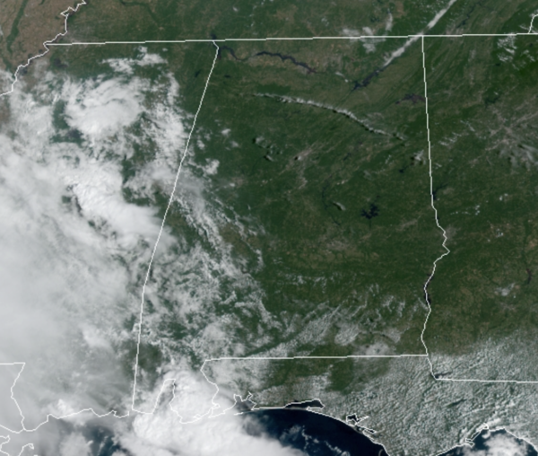
Low humidity and ample sunshine continue to highlight our forecast for the rest of today. Temperatures this afternoon are a few degrees warmer than previous days as widespread mid and upper 80s cover Alabama.
REST OF WEEK: Moisture levels will rise a bit in the coming days, so there will be more clouds in the sky, and we will need to mention the chance of a few isolated showers. These look to be mainly across West and South Alabama, and even there they will be few and far between as the chance for rain is around 20%. Highs the rest of the week will be continue to be in the mid to upper 80s, with some low 90s possible as well across the state.
WEEKEND WEATHER: Not much change in the forecast for Saturday with most locations remaining dry with highs in the mid-80s. By Sunday, a few more showers are possible statewide, but again the odds of any one community seeing rain remain low, in the 20-30% range. Highs Sunday should be in the lower 80s.
IN THE TROPICS: The National Hurricane Center is issuing advisories on Hurricane Sam, located several hundred miles east of the northern Leeward Islands. Also, we continue to watch the remnants of Peter, and likely soon to be Victor and Wanda.

1. A broad area of low pressure located several hundred miles southwest of the Cabo Verde Islands continues to produce an area of disorganized showers and thunderstorms. Environmental conditions are conducive for gradual development, and a tropical depression is likely to form during the next couple of days while the system moves westward to west-northwestward at 5 to 10 mph over the central tropical Atlantic. Formation chance through 5 days…high…80 percent.
2. Showers and thunderstorms are showing signs of organization in association with a tropical wave and broad area of low pressure located over the far eastern tropical Atlantic. Environmental conditions are conducive for development, and a tropical depression is likely to form in a day or two while the disturbance moves west-northwestward at 10 to 15 mph over the eastern tropical Atlantic. Formation chance through 5 days…high…90 percent.
3. A well-defined low pressure area associated with the remnants of Peter is located about 350 miles east-northeast of Bermuda. The associated showers and thunderstorms have increased a little this morning, but are still not well organized. This system could become a short-lived tropical depression while moving northeastward at about 10 mph before upper-level winds increase on Wednesday. Formation chance through 48 hours…medium…50 percent.
HURRICANE SAM: The eye of Hurricane Sam was located near latitude 17.5 North, longitude 54.3 West. Sam is moving toward the northwest near 8 mph and this motion with an increase in forward is expected during the next couple of days.
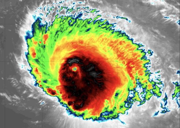
A turn toward the north is forecast to occur by Friday. On the forecast track, Sam will pass well to the east of the northern Leeward Islands through Wednesday.

Maximum sustained winds remain near 130 mph with higher gusts. Sam is a category 4 hurricane on the Saffir-Simpson Hurricane Wind Scale. Some fluctuations in intensity are expected during the next couple of days, but Sam is forecast to remain a major hurricane through late this week. Hurricane-force winds extend outward up to 40 miles from the center and tropical-storm-force winds extend outward up to 140 miles. The estimated minimum central pressure is 952 mb (28.12 inches).
BEACH FORECAST CENTER: Get the latest weather and rip current forecasts for the beaches from Fort Morgan to Panama City on our Beach Forecast Center page. There, you can select the forecast of the region that you are interested in visiting.
WORLD TEMPERATURE EXTREMES: Over the last 24 hours, the highest observation outside the U.S. was 123.8F at Maun, Botswana. The lowest observation was -97.6F at University Dome, Antarctica.
CONTIGUOUS TEMPERATURE EXTREMES: Over the last 24 hours, the highest observation was 101F at Death Valley, CA. The lowest observation was 18F at Peter Sinks, UT.
Category: Alabama's Weather, ALL POSTS
About the Author (Author Profile)
Macon, Georgia Television Chief Meteorologist, Birmingham native, and long time Contributor on AlabamaWX. Stormchaser. I did not choose Weather, it chose Me. College Football Fanatic. @Ryan_StinnetSubscribe
If you enjoyed this article, subscribe to receive more just like it.


