Sunday Weather Xtreme: A Nice Halloween in Store
It’s not many tricks and a good many treats as we look at this forecast. Here we go!
HAPPY HALLOWEEN: After a dreary couple of days that would have been very fitting for All Hallows Eve, skies are beginning to clear across the area this morning. Temperatures are on the seasonably cool side, with readings in the 40s to near 50 degrees. The average low temperature for October 31st in Birmingham is 50F. The average high is 71F, and we will be right below to near that today with highs in the upper 60s to lower 70s. Under partly cloudy skies, tonight’s low will be in the middle to upper 40s. Nearly perfect conditions for little ghosts and goblins doing their trick or treating.
THE TENTH MONTH WILL BE IN THE BOOKS by tomorrow. Let’s look back on the month that was October. We will end the month with an average temperature of 67.8F, which is slightly above the normal reading of 64.1F. The average high was 77.1F, 1.4 degrees above the normal monthly high of 75.7F. The average low will end up around 58.6F, well above the normal monthly minimum of 52.9. These normals are based on the 1980-2010 averages as I don’t have the updated specific numbers yet for 1990-2020. 90-degree readings are rare in October in Birmingham, and true to form, we haven’t seen any this month. The 9.39 inches of rain so far this month will likely go down in the record books as the official total. That is nearly six inches above average (3.44). When numbers get that high, you start thinking about records. Indeed, October 2021 will go down in the record books as the fourth wettest October of all time. Birmingham has picked up 63.50 inches so far this year, which places us at #22 on the all-time total.
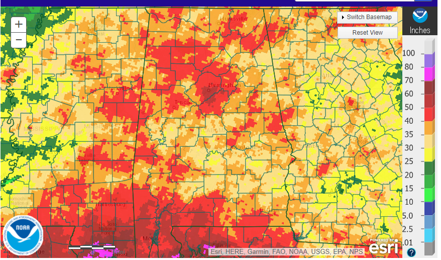
THREE MONTH RAINFALL TOTALS ARE IMPRESSIVE: In fact, much of Central and North Alabama have received 30-50 plus inches of rain over the past six months. For most areas that is 125-200% or more above normal. Southern Jefferson and northern Shelby Counties have been the epicenter of this with two major flooding events. I have measured 67.40 inches of rain so far this year from my station near the Acton Road exit off I-459.
NEW WORK WEEK: The pesky low pressure that has given us the clouds and light rain is exiting to the northeast this morning. In its place, weak high pressure will build across Alabama and the Southeast. This will give us fair and seasonably mild conditions Monday and Tuesday. Another big upper trough will move to our north by midweek, pushing another front our way Tuesday evening. It will be a dry front, but the northerly winds behind it will deliver a reinforcing shot of drier, cooler air. Highs on Wednesday will be about 7-10 degrees cooler than those of Tuesday. Thursday highs won’t get out of the 50s and neither will Friday’s. This is because a disturbance will be passing to our south on Thursday and Friday, causing clouds and a few showers.
WEEKEND: The weekend forecast looks good with dry conditions and temperatures in the 50s to lower 60s, and lows in the upper 30s. An approaching front could trigger showers Sunday night, however.
VOODOO COUNTRY: out at the end of the forecast period two weeks from now, it appears that sluggish fronts will bring heavy rains to parts of the Mid-South. It seems that heavy rain will be held to our northwest thanks to a strong subtropical high. It will bear watching.
WHAT ABOUT WANDA: Subtropical Storm Wanda formed late last night over the northern Atlantic. The storm transitioned from non-tropical to subtropical last night and was named with 50 mph winds. It is moving ESE at 20 mph. That general direction will be maintained for the next day or but the forward speed will decrease. Wanda will meander about tomorrow before turning sharply to the north or northeast by the middle of the week. The system will likely maintain its strength during the next several days. Although the system will remain over relatively cool waters of about 23-24 C during the next couple of days, cold air aloft should aid in the continued development of deep convection and could allow the system to strengthen slightly during that time period. Beyond that time, Wanda should begin to move over cooler waters and that will likely end its opportunity to gain strength and lead to post-tropical transition by the end of the forecast period.
GULF COAST WEATHER: It looks like a beautiful week along the gorgeous beaches of Alabama and Northwest Florida. Conditions should be dry until Thursday afternoon or evening when showers and storms will return to the area. Friday won’t be a washout, but there will be a few showers and storms in the neighborhood. The weekend looks dry. It will be mild through Thursday, with highs on the lower side of the 70s except for Thursday with upper 70s will rule. Lows will be in the 50s. By the weekend, highs will drop back into the 60sm and even 50s on Saturday as cooler air filters into the area. Lows will actually flirt with the upper 30s, but the 40-degree line will probably hold. The surf is running around one foot, making for a lower rip current risk. Water temperatures are in the upper 60s.
DANCING WITH THE STATS: The high of 56F Friday at Tuscaloosa tied the record for the coolest October 28th there.
AURORA ALERT: Everyone north of a line from Washington State to Washington DC was on alert for a sighting of the Northern Lights, with G3 Geomagnetic Storm conditions likely. The actual result was sort of disappointing, but some people did end up with a little auroral delight.
ADVERTISE WITH US: Deliver your message to a highly engaged audience by advertising on the AlabamaWX.com website. The site enjoyed 10.2 MILLION page views in the past 12 months. Don’t miss out! We can customize a creative, flexible, and affordable package that will suit your organization’s needs. Contact me, Bill Murray, at (205) 687-0782, and let’s talk.
WEATHERBRAINS: Fabulous show last week with aviation expert Paul Suffern. Check out the show at www.WeatherBrains.com. You can also subscribe on iTunes. You can watch the show live at: http://live.bigbrainsmedia.com/ You will be able to see the show on the James Spann 24×7 weather channel on cable or directly over the air on the dot 2 feed. Join our Brainy Bunch weekly newsletter here.
ON THIS DATE IN 1999: Talk about a wet month. Measurable rain fell on every day of the month of October 1999 in Juneau AK. This was the first time that had ever occurred at that location since weather records began in 1943. From August 13 until October 31, rain fell on 78 of the 80 days! Follow my weather history tweets on Twitter. I am @wxhistorian at Twitter.com.
Category: Alabama's Weather, ALL POSTS, Tropical, Weather Xtreme Videos
About the Author (Author Profile)
Bill Murray is the President of The Weather Factory. He is the site's official weather historian and a weekend forecaster. He also anchors the site's severe weather coverage. Bill Murray is the proud holder of National Weather Association Digital Seal #0001 @wxhistorianSubscribe
If you enjoyed this article, subscribe to receive more just like it.


