Midday Nowcast: Rain and Front on the Way
A cold front will be moving through Alabama today and is bringing rain and a few storms as it does. At the writing of this forecast, the rain is just now entering into Northwest Alabama and over the next few hours, the rain will continue to slide east through the state.
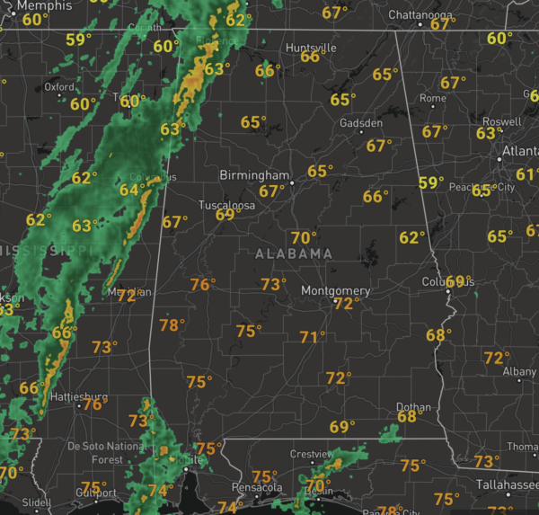
Severe storms are not expected with the main dynamic support passing well to the north; the main window for rain is now through 8PM. Rain amounts should be less than 1/2 inch and the rain will end later this evening for most communities. The sky will clear tonight and lows will fall back into the 40s.
FINE FRIDAY: Tomorrow will be a sunny, cooler day with highs in the mid to upper 60s. Tomorrow night, another front drops into the state and will bring a much colder air mass into the state for the weekend. The front will come through in dry fashion with only some accompanying clouds.
FRIDAY NIGHT LIGHTS: For the high school playoff games Friday night, the sky will be clear with temperatures mostly in the 40s.
COLDER WEEKEND WEATHER: A new air mass for the weekend means Saturday and Sunday will feature sunny, cool days, with clear and cold night. Highs in the low 50s are expected Saturday with breezy conditions, which will make it feel colder at times. Highs should make it into the mid and upper 50s Sunday. Lows will be in the 30s, and Sunday morning should be the coldest with a freeze anticipated with lows in the upper 20s and lower 30s.
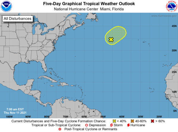
IN THE TROPICS: Showers and thunderstorms associated with a storm-force non-tropical area of low pressure located more than 1000 miles east-northeast of Bermuda have changed little in organization since last night. Although there is still a small chance the system could become a short-lived subtropical storm today, the system is quickly moving over cooler waters and the likelihood of subtropical development has decreased. By this weekend, the system is expected to be absorbed by a larger non-tropical low. Formation chance through 48 hours…low…30 percent.
BEACH FORECAST CENTER: Get the latest weather and rip current forecasts for the beaches from Fort Morgan to Panama City on our Beach Forecast Center page. There, you can select the forecast of the region that you are interested in visiting.
WORLD TEMPERATURE EXTREMES: Over the last 24 hours, the highest observation outside the U.S. was 107.8F at Mariental, Namibia. The lowest observation was -68.6F at Vostok, Antarctica.
CONTIGUOUS TEMPERATURE EXTREMES: Over the last 24 hours, the highest observation was 92F at Rio Grande Village, TX. The lowest observation was 11F at Vernal, UT.
Category: Alabama's Weather, ALL POSTS
About the Author (Author Profile)
Macon, Georgia Television Chief Meteorologist, Birmingham native, and long time Contributor on AlabamaWX. Stormchaser. I did not choose Weather, it chose Me. College Football Fanatic. @Ryan_StinnetSubscribe
If you enjoyed this article, subscribe to receive more just like it.


