

Sunday Weather Xtreme: An Active Pattern Ahead
A winter fog for rain:
A fact most everywhere,
In valley and on plain.
Says a famous piece of weather folklore. And there is a tremendous amount of fact behind it. The difference is that a summer fog is generally always radiation based, meaning the sky above must be clear for the fog to form. A winter fog is usually generated by warm, moist air moving into cooler air and condensing. Since that means an approaching warm front, you can usually look for rain soon and that is indeed the case. A dense fog advisory is in effect for the western and southern sections of Central Alabama, as well as surrounding parts of Mississippi, South Alabama, and Northwest Florida also have dense fog advisories. The fog will dissipate by mid-morning.
ACTIVE PATTERN STRAIGHT AHEAD: The upper air pattern usually tells the big story, and that is the case here. In fact, the upper pattern is going to start looking more and more like the old Scream Machine roller coaster at Six Flags in Atlanta. This morning, we have a split jet stream, with the northern stream bottled up over the northern tier of states, with the southern stream buckling into a sharp trough over the southwestern United States. Over the next few days, the northern trough will deepen and the two streams will come together, allowing for a more progressive pattern. By Wednesday, a deep trough will form, with its axis to the west of Alabama. That will be followed a building ridge starting Thursday. A very deep trough will be approaching by the weekend, and this will present the potential for severe weather that we have been missing. A huge ridge will take over the country the week of the 13th, leading to fair and warm conditions for Alabama and much of the nation.
FOR THE REST OF YOUR SUNDAY: At the surface, we have a cold front just to our northwest. That front should lift back to the north today as the next disturbance swings our way in the southern stream. This should allow for less of the drizzle and clouds we saw yesterday, although it isn’t going to be a sun-fest. At best, we can expect is partly cloudy skies at times in the afternoon. High temperatures will range from 68-74F, depending on how much sunshine that you see. There could be a few showers across the area, but they should be isolated in nature.
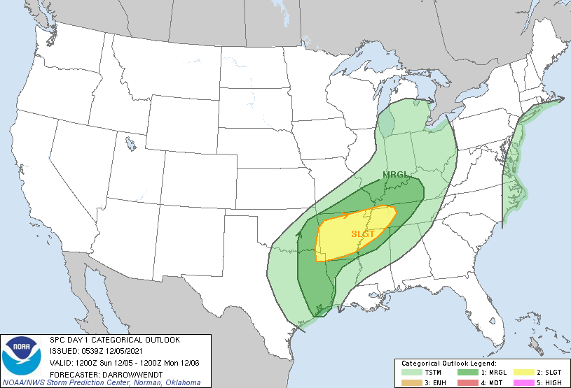
TONIGHT: Watching storms to our northwest will be the game overnight. The line of storms will be approaching Northwest Alabama. Severe storms are expected to be in the picture, but by the time they reach Alabama, they will be losing steam. Could see a warning or two over the Northwest corner of the state, but shouldn’t get out of hand. Just keep the Weatheradio on just in case, and check back during the day for updates here.
MONDAY: The line of mostly rain and a little thunder will be pushing southeastward. Expect 3-4 hours of rain, and about a quarter to three quarters of an inch of rain. Highs on Monday will be in the middle and upper 60s.
INTO TUIESDAY: There are signs that the front will not make it all the way through Central Alabama giving us a continued chance of rain Monday night into Tuesday. Temperatures will be colder across the area. Lows will be in the 30s to lower 40s. Tuesday highs will be in the upper 50s with a few showers. Rain becomes likely again Tuesday night into Wednesday.
THURSDAY RESPITE: We get a little break Thursday as partly cloudy and cool conditions settle across the area. But I said brief, because showers will return by Thursday evening as the next approaching trough pulls a warm front back to the north.
STRONG STORMS: Showers will continue Friday with warming temps and increasing humidity. Showers and storms will become likely Saturday night. Some of these storms could be strong to severe. They will bear watching.
A FEW FLAKES? On the backside of the front, the rain may change briefly to snow over Tennessee, and a few flakes could fall over North Alabama.
FAIR FOLLOWING THE FRONT: The week of the 13th will feature high pressure. Expect sunny to partly cloudy skies with highs in the 60s and lows in the 40s.
BEACHCAST: Two or three rounds of showers and storms will impact the beaches of Alabama and Northwest Florida starting Monday night into the weekend. Highs will be in the 70s and lows will be in the 60s. Water temperatures are in the lower 60s.
Click here to see the Beach Forecast Center page.
ADVERTISE WITH US: Deliver your message to a highly engaged audience by advertising on the AlabamaWX.com website. The site enjoyed nearly 26 MILLION page views in the past 12 months. Don’t miss out! We can customize a creative, flexible, and affordable package that will suit your organization’s needs. Contact me, Bill Murray, at (205) 687-0782, and let’s talk.
WEATHERBRAINS: This week, the panel will hold a retirement party of the head of the National Weather Service, Dr. Louis Uccellini. Check out the show at www.WeatherBrains.com. You can also subscribe on iTunes. You can watch the show live at live.bigbrainsmedia.com or on James’ YouTube Channel You will be able to see the show on the James Spann 24×7 weather channel on cable or directly over the air on the dot 2 feed.
ON THIS DATE IN 1952: Stagnant high pressure would cause London’s worst ever smog event. Over 4,000 people died as the sooty mess caused respiratory distress. Follow my weather history tweets on Twitter. I am @wxhistorian at Twitter.com.
Category: Alabama's Weather, ALL POSTS, Severe Weather
About the Author (Author Profile)
Bill Murray is the President of The Weather Factory. He is the site's official weather historian and a weekend forecaster. He also anchors the site's severe weather coverage. Bill Murray is the proud holder of National Weather Association Digital Seal #0001 @wxhistorianSubscribe
If you enjoyed this article, subscribe to receive more just like it.


