Noon Update: A Warm, Humid, and Windy Saturday
Here is a really busy weather graphic to talk from late this morning:
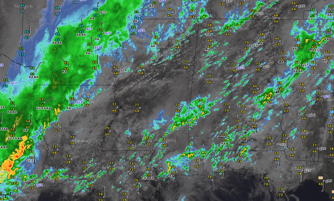
Step outside late this morning, and the humidity really hits you. Dewpoints are in the May or June ranges, running between 66-70F across Central Alabama, with lower 70s over South Alabama. The temperature/dewpoint at BHM is 72F/70F, which is really unusual for December. The numbers of the map are station plots that show temp in the top left, dewpoint underneath it, a wind barb showing direction and velocity, with the gusts in the lower right. Winds were gusting to 22 mph at the Birmingham Airport.
In fact, the precipitable water measurement of 1.61 inches on this morning’s sounding from the Shelby County Airport is a record for December 18th at 12z.
Skies are variably cloudy. I love this kind of sky day, with a good mix of clouds and sunshine playing hide and seek. There are broken clouds at 1,200 feet at Birmingham with another layer of broken clouds at 25,000 feet.
A few showers are taking advantage of the instability. CAPE values are running 500-1,000 j/kg over Northeast Alabama, with 1,000-1,500 joules over North Alabama, and values above 1,5000 joules to the south and west of Birmingham. Values are over 2,500 over Southwest Alabama. The combination of warmth, moisture, and instability is setting the stage for showers and storms.
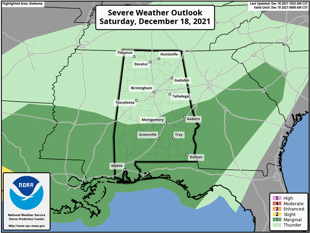
The SPC has a Marginal Risk of severe thunderstorms (1/5) over the southern half of Alabama through tonight.
There have been several severe thunderstorm warnings and even a tornado warning over Southeast Texas.
A cold front lies to our northwest, draped lazily across the Missouri Bootheel, Arkansas, and Northwest Texas. That front will push southeastward through the afternoon and reach I-59 by evening. Showers and some storms will increase across the state through the peak heating of the day, assisted by the lift from the approaching front. The main activity appears that it will be centered over South and Southeast Alabama, where the marginal risk is placed.
A few pre-frontal showers and storms will develop and move across the area this evening. But the rain doesn’t appear that it will be widespread or heavy.
Temperatures will be falling from the 60s during the evening, reaching the 40s quickly behind the front. By midnight, Tuscaloosa, Birmingham, and Gadsden will be in the 50s, heading toward lows in the 30s over Northwest Alabama, with 40s elsewhere across Central Alabama. 50s will hang on for dear life over South Alabama.
Tomorrow will be the big shock, with locations northwest of I-59 struggling to get out of the 40s. 50s elsewhere. Some clearing will work in from the northeast on Sunday afternoon, but skies should return to nearly cloudy overnight. Clouds may persist through Monday and Tuesday as a low moves across the Gulf of Mexico. Most of the rain will stay to our south, affecting coastal sections only.
Category: Alabama's Weather, ALL POSTS, Severe Weather
About the Author (Author Profile)
Bill Murray is the President of The Weather Factory. He is the site's official weather historian and a weekend forecaster. He also anchors the site's severe weather coverage. Bill Murray is the proud holder of National Weather Association Digital Seal #0001 @wxhistorianSubscribe
If you enjoyed this article, subscribe to receive more just like it.


