Midday Nowcast: Warm and Muggy End of Year; Severe Threat Late Saturday
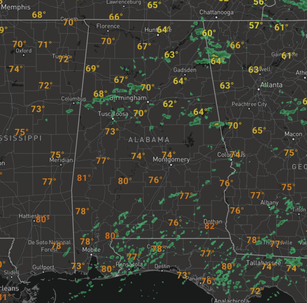
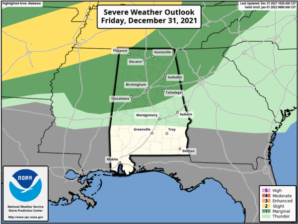
For today, it is a mainly cloudy day with some scattered showers, It is very warm as well with temperatures again in the 70s for most locations across North/Central Alabama. We do note, the SPC has expanded the “marginal risk” (level 1/5) across North/Central Alabama today including Birmingham, Tuscaloosa, and Anniston, as there could be a few stronger storms develop in this unstable air mass in place, if they develop gusty winds are certainly possible.
Ringing in the New Year tonight, it will be mild with temperatures in the 60s and some scattered light rain is possible. Also, there could be some areas of fog.
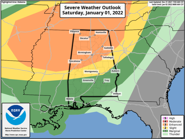
NEW YEAR’S DAY: All eyes are on tomorrow as an approaching strong cold front will bring more active weather to the state tomorrow and tomorrow night. The SPC has defined an “enhanced risk” (level 3/5) for about the northern half of Alabama, as far south as Forkland, Jemison, and Heflin. A “slight risk” (level 2/5) extends down to Sweet Water, Montgomery, and Auburn… and a “marginal risk” (level 1/5) covers the rest of South Alabama except for Dothan, where no severe storms are expected.
TIMING: Tomorrow afternoon, we could see some discrete supercell thunderstorms out ahead of the main line of storm and these could begin to develop as early as 3PM across portions of West and Northwest Alabama. These will be the initial concern as we wait on the main line to arrive during the evening hours. This long line of thunderstorms (QLCS) will push through the state tomorrow night, first impacting Northwest Alabama late afternoon and evening, then arriving in the Birmingham Metro and the Interstate 59 corridor around 6-7PM, then finally pushing into East Alabama by 10PM and affecting South Alabama during the pre-dawn hours Sunday. Once the front passes your location, the threat will end.
THREATS: The discrete cells that form ahead of the line could produce tornadoes and large hail. In fact, the SPC has defined a hatched area in the “enhanced risk,” meaning there could be a few significant tornadoes (defined as EF-2 or higher). As the line arrives, and pushes through tomorrow night, damaging straight line winds are the primary threat, but some isolated embedded tornadoes are possible as well. With the recent rains, additional heavy rainfall could produce some flooding problems.
CALL TO ACTION: This is nothing unusual for Alabama this time of year. We have all done this before, and we will get through this round too, but you must be prepared and be ready to implement your severe weather safety plan.
*Be sure you can hear severe weather warnings. NEVER an outdoor siren. The baseline is a NOAA Weather Radio; every home and business needs one. On your phone, be sure emergency alerts are enabled, and have the ABC 33/40 Weather app installed.
*Be sure everyone in your family knows the safe place in your home, and have helmets for everyone, along with portable airhorns and hard sole shoes.
*If you live in a mobile home, you can’t stay there if you are in a tornado warning polygon. Know where you are going, and the quickest way to get there. Arrange transportation if needed. Develop a plan now, instead of thinking about it during the middle of the event.
*Know how to watch our coverage. ABC 33/40 is free, over the air television. We stream the coverage through the ABC 33/40 app, the ABC 33/40 web site, and on the ABC 33/40 Facebook page. If you have an Apple TV, Roku, Chromecast, etc, you can watch via the NewsOn app, or Facebook Watch.
*Remember, you can be a hero during severe weather events. If know of a relative or friend in a tornado warning polygon, call or text them. You can a part of the process.
Remember, the forecast can change, so watch for updates.
SUNDAY: The cold front pushes through Alabama Saturday night and much colder air rolls into Alabama. High temps will occur very early in the day and will fall through the 40s, possibly reaching the 30s by late afternoon. There will be some lingering areas of light rain, and as the cold air rushes into the state, there will likely be some snow flurries over the northern half of the state, but these will not have any impacts. Temperatures will be in the 20s by Monday morning.
NEXT WEEK: The first half of the week will be sunny and colder. Highs Monday will be in the 40s, but 50s should return on Tuesday and Wednesday. It looks like rain chances could return by next Thursday.
BEACH FORECAST CENTER: Get the latest weather and rip current forecasts for the beaches from Fort Morgan to Panama City on our Beach Forecast Center page. There, you can select the forecast of the region that you are interested in visiting.
WORLD TEMPERATURE EXTREMES: Over the last 24 hours, the highest observation outside the U.S. was 114.8F at Rivadavia, Argentina. The lowest observation was -65.6F at Ekyuchchyu, Russia.
CONTIGUOUS TEMPERATURE EXTREMES: Over the last 24 hours, the highest observation was 91F at Cotulla, TX. The lowest observation was -29F at Cavalier, ND.
WEATHER ON THIS DATE IN 1963: A snowstorm struck the Deep South. Meridian, MS, received 15 inches of snow, 10.5 inches blanketed Bay St Louis MS, and 4.5 inches fell at New Orleans LA. Freezing temperatures then prevailed for New Year’s Day.
Category: Alabama's Weather, ALL POSTS
About the Author (Author Profile)
Macon, Georgia Television Chief Meteorologist, Birmingham native, and long time Contributor on AlabamaWX. Stormchaser. I did not choose Weather, it chose Me. College Football Fanatic. @Ryan_StinnetSubscribe
If you enjoyed this article, subscribe to receive more just like it.


