Tornado Watch May Be Issued Within the Next couple of Hours for Portions of North Alabama
The latest Mesoscale Discussion from the SPC is out, and it states that a tornado watch is likely to be issued within the next couple of hours for portions of North Alabama and up into portions of East Tennessee and portions of southern Kentucky. Here is the text from the discussion:
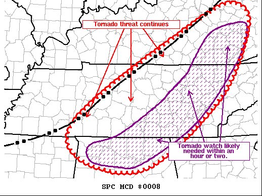
SUMMARY… Threat for damaging wind gust and tornadoes continues across central KY and middle TN within Tornado Watch 3. This threat will persist downstream into more of central KY, middle TN, and northern AL, where a watch will likely be needed.
DISCUSSION… Recent observations place the outflow boundary from about 20 miles south of LEX southwestward to just southeast of BWG, continuing southeastward through western TN to about 20 miles southeast of MEM. Numerous shallow but strong/organized cells have developed along this outflow boundary, and lightning has become slightly more frequent over the last hour. General trend with the stronger storms developing within the line is for an initially cell-in-line structure with a strong, more organized updraft. This more cellular structure then relatively quickly trends towards bowing line segments as the outflow boundary continues pushing southeastward. As such, a relatively brief period for tornadogenesis exists before the storms then transition to more of a damaging wind threat. Initial, more discrete development has also occurred sporadically ahead of the line, with a longer duration of more cellular structure contributing to a slightly greater tornado risk. These storms also trend towards bowing line segments as the outflow overtakes them.
This overall pattern is expected to continue for at least the next few hours as the outflow pushes quickly eastward/southeastward. Current motion places the outflow near the edge of Tornado Watch 3 by 1930Z-2000Z. Winds are currently a bit more veered downstream, but vertical shear remains very strong. As such, supercells capable of damaging wind gusts and tornadoes remain possible, and a downstream watch will likely be needed.
Category: Alabama's Weather, ALL POSTS, Severe Weather
About the Author (Author Profile)
Scott Martin is an operational meteorologist, professional graphic artist, musician, husband, and father. Not only is Scott a member of the National Weather Association, but he is also the Central Alabama Chapter of the NWA president. Scott is also the co-founder of Racecast Weather, which provides forecasts for many racing series across the USA. He also supplies forecasts for the BassMaster Elite Series events including the BassMaster Classic.Subscribe
If you enjoyed this article, subscribe to receive more just like it.


