SPC Expands Slight Risk Eastward Across the Southern Parts of Central Alabama
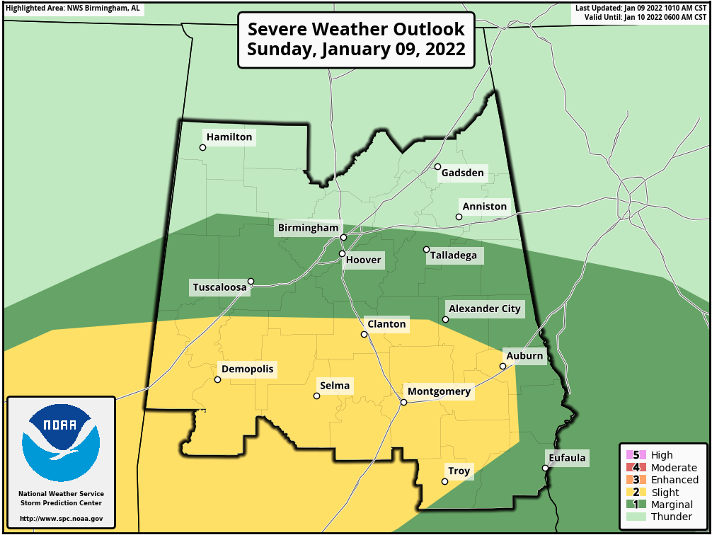
The Storm Prediction Center has expanded the Slight Risk eastward to now includes locations along and south of a line from Panola (Sumter Co.) to Jemison (Chilton Co.) to Opelika (Lee Co.) and along and west of a line from Opelika to Comer (Barbour Co.) to Spring Hill (Pike Co.). A Marginal Risk continues for locations along and south of a line from Fayette (Fayette Co.) to Fultondale (Jefferson Co.) to Woodland (Randolph Co.).
Increased moisture levels along with the daytime heating, mixed with the wind shear, conditions look to be favorable for supercells, some of which may be discrete in nature. Isolated tornadoes and damaging wind gusts look to be the main threats, with a smaller threat of large hail with any storm that becomes severe. Here is the latest from the SPC:
SUMMARY… Damaging gusts and a couple of tornadoes will be possible today across parts of Louisiana, Mississippi, and Alabama.
A persistent MCS continues to track eastward across central MS late this morning. This cluster of storms is within a baroclinic zone along the northern edge of returning low-level moisture, with dewpoints in the upper 60s across southern MS and southwest AL. Visible satellite imagery shows considerable breaks in the clouds over this region, helping to mix the boundary-layer and destabilize the air mass. Moisture will continue to increase across southern AL through the afternoon, with a corridor of MLCAPE over 1000 J/kg expected.
The storms over central MS appear slightly elevated at this time. However, continued heating should eventually result in surface-based convection. Vertical shear profiles are favorable for supercells, and recent CAM guidance also suggests that semi-discrete storm mode will be preferred. For these reasons, will maintain the SLGT risk for LA/MS and expand it somewhat eastward for late-afternoon storms spreading across southern AL. Isolated tornadoes and damaging wind gusts appear to be the main threats. Refer to MCD #0055 for further short-term details.
Category: Alabama's Weather, ALL POSTS, Severe Weather
About the Author (Author Profile)
Scott Martin is an operational meteorologist, professional graphic artist, musician, husband, and father. Not only is Scott a member of the National Weather Association, but he is also the Central Alabama Chapter of the NWA president. Scott is also the co-founder of Racecast Weather, which provides forecasts for many racing series across the USA. He also supplies forecasts for the BassMaster Elite Series events including the BassMaster Classic.Subscribe
If you enjoyed this article, subscribe to receive more just like it.


