Sunday Weather Xtreme Video: Winter Weather Advisories, Winter Storm Warning Across Alabama for Snow
Then roads started to become slippery in Sumter County in West Alabama. Chief Vaughn reported 1 inch of snow with accidents on I-20. Snow was reported at Demopolis.
Winter weather advisories were extended southward to encompass the area which will be traversed by the band of heavy snow. Here are those advisories this morning:
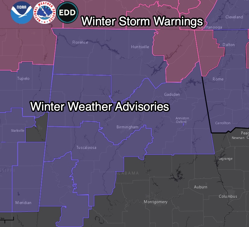
Up to an inch of snow is expected in the winter weather advisory area. A lot of folk swill get 1-2 inches. Some more. Some none at all. Sorry about that.
Northeast Alabama could see 2-4 inches of snow in the winter storm warning area.
But roads will become slippery and hazardous pretty quickly in areas that see the snow bursts. Check conditions before leaving this morning. Snow could cause big problems getting home by mid to late morning across the advisory area.
Other reports:
…Snow is falling across much of Sumter and parts of Marengo counties at this hour. Snow will accumulate quickly to 1-2 inches in the heavier snow bursts.
…Already an inch of snow on the ground in Sumter County, with accidents reported on I-20/59.
…Just received a report of 1.75 inches of snow in the northern portion of Meridian.
…There are now reports of sleet and snow from several spots across South Central Alabama, including Auburn.
The snowfall will move northeast with the upper low, which will be pushing into Georgia by early afternoon.
We will see some slick spots continuing to form on the roadways through the morning; plus, gusty winds and locally heavy snow showers may lead to a few branches or tree limbs falling and causing minor power outages. Any water remaining on the roadways after dark most likely will freeze, as low temperatures will dip well below freezing.
Black ice on roads will be a problem through much of the advisory and winter storm warning areas through at least Monday morning. Things should improve by Monday afternoon, underneath plenty of sunshine and highs in the lower 40s to the lower 50s.
TWO WAVES FOR LATER IN THE WEEK
Skies will be sunny on Tuesday, and it will be a little warmer, reaching the lower to mid-50s for most.
Another cold front will move into the area late on Wednesday that will bring a decent chance of showers for the afternoon through the overnight hours, with showers departing the area on Thursday and colder air following.
A second wave will push along the Gulf on Friday, perhaps bringing more ice and snow to parts of Alabama. Stay tuned.
VOODOO TERRITORY
The end of the period, around the 25th, looks cool and dry for Alabama.
ON THIS DATE IN 2003
A foot of snow fell on Cape Hatteras, NC. Follow my weather history tweets on Twitter. I am @wxhistorian at Twitter.com.
BEACH FORECAST
Rain will be moving out this morning along the beautiful beaches of Alabama and Northwest Florida. Temperatures will be cool today and tomorrow, struggling to get out of the 40s during the day. Lows will be in the 30s tonight and Monday night. Temperatures will start to moderate by Tuesday and highs will be back close to 70F by Thursday. Just in time for another cold front that will bring back rain for Thursday and Friday, setting the stage for a fair but chilly weekend. There is high surf along the beaches today and that will continue tonight. There will be a high risk of rip currents through Monday.
ADVERTISE ON THE BLOG
The numbers are in! The blog enjoyed 26.7 million pageviews in 2021. Don’t miss out! We can customize a creative, flexible, and affordable package that will suit your organization’s needs. Contact Bill Murray at (205) 687-0782.
E-FORECAST SIGN UP
Get the Alabama Weather Blog’s Seven-Day Forecast delivered directly to your inbox by email twice daily. It is the most detailed weather forecast available in Central Alabama. Subscribe here… It’s free!
CONNECT WITH THE BLOG ON SOCIAL MEDIA
You can find the AlabamaWx Weather Blog on Facebook and Twitter.
WEATHERBRAINS
This week, the panel will entertain storm chaser extraordinaire, Roger Hill. Check out the show at www.WeatherBrains.com. You can also subscribe on iTunes. You can watch the show live at live.bigbrainsmedia.com or on James’ YouTube Channel You will be able to see the show on the James Spann 24×7 weather channel on cable or directly over the air on the dot 2 feed.
Category: Alabama's Weather, ALL POSTS, Winter Weather
About the Author (Author Profile)
Bill Murray is the President of The Weather Factory. He is the site's official weather historian and a weekend forecaster. He also anchors the site's severe weather coverage. Bill Murray is the proud holder of National Weather Association Digital Seal #0001 @wxhistorianSubscribe
If you enjoyed this article, subscribe to receive more just like it.


