

Midday Nowcast: Sunny and Warmer Today
It certainly was cold this morning with widespread 20s, but we are seeing a nice warm-up with abundant sunshine and many locations will surge into the low and mid 50s this afternoon. Tonight will be mainly clear, but not as cold with lows in the upper 30s to low 40s.
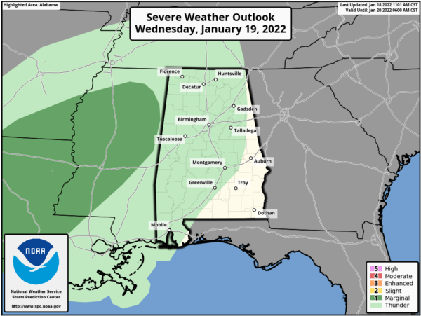
MIDWEEK FRONT: Clouds will increase tomorrow ahead of a cold front. Rain will push into the Northwest Alabama late in the day with widespread rain likely statewide Wednesday night. There could be a rumble of thunder in spots, but for now severe storms are not expected in Alabama. The SPC maintains “marginal risk” (level 1/5) of severe thunderstorms west of the state for parts of Southeast Arkansas, Louisiana, and Mississippi.
As the front moves south, much colder air will roll into North Alabama early Thursday morning and continue to spill south. There is a chance there could be some overlap between the sub-freezing air and the back edge of the precipitation associated with the cold front. Meaning, there could be a window for a little freezing rain, freezing drizzle, or sleet over parts of North Alabama Thursday morning, mainly north of Birmingham. Temperatures will hold in the 30s all day across the northern half of Alabama.
FOUL FRIDAY: Cold air will be in place and this time of year we have to watch for any feature that could produce precipitation in the cold air. As we mentioned yesterday, a wave of low pressure is expected to form on the front in the northern Gulf of Mexico, and spread precipitation northward across Alabama. There is a chance this could begin in the form of freezing rain for parts of North Alabama Friday morning, where temperatures will be below freezing.
Temperatures will warm into the upper 30s and lower 40s, so during the day, it looks to be a cold, but all liquid precipitation. As temperatures begin to fall late in the day, we could see a transition back to frozen precipitation, in the form of light snow. There remains a great deal of model inconsistency, and forecast confidence remains low.
Bottom line is that it is still too early for a specific forecast, but just be aware some winter weather impact is possible Friday afternoon and Friday night over parts of North or Northeast Alabama. We will have much better clarity over the next 24 hours.
BEACH FORECAST CENTER: Get the latest weather and rip current forecasts for the beaches from Fort Morgan to Panama City on our Beach Forecast Center page. There, you can select the forecast of the region that you are interested in visiting.
WORLD TEMPERATURE EXTREMES: Over the last 24 hours, the highest observation outside the U.S. was 113.0F at Rivadavia, Argentina. The lowest observation was -63.9F at Delyankir, Russia.
CONTIGUOUS TEMPERATURE EXTREMES: Over the last 24 hours, the highest observation was 80F at Zapata, TX. The lowest observation was -11F at Seagull Lake, MN.
Category: Alabama's Weather, ALL POSTS
About the Author (Author Profile)
Macon, Georgia Television Chief Meteorologist, Birmingham native, and long time Contributor on AlabamaWX. Stormchaser. I did not choose Weather, it chose Me. College Football Fanatic. @Ryan_StinnetSubscribe
If you enjoyed this article, subscribe to receive more just like it.


