Still Rather Chilly Heading Toward the Midday Hour
TODAY’S WEATHER: A good portion of Central Alabama has clear skies and plenty of sunshine, where clouds are in the process of moving out of the area in the southeastern parts of the area. Temperatures as of the 11 am roundup were in the mid 30s to the lower 40s across Central Alabama. Montgomery was the warm spot at 42 degrees. Haleyville was the cool spot at 34 degrees. Birmingham was sitting at 37 degrees. Skies will continue to clear out and afternoon highs will reach the lower to mid 40s across the area, with a couple of locations hitting the upper 40s in the extreme southern and southeastern parts of the area. Skies will be mainly clear tonight and through the overnight hours, as lows will once again head below freezing and reach the lower to mid 20s. Please, bring your pets indoors as these temperatures are too cold for them to stay outside.
SUNDAY’S WEATHER: After the very cold start, the good news is that we’ll have maximum sunshine and warmer temperatures. The only bad news is that these daytime highs will still be below normal for this part of winter. Highs will be in the upper 40s to the lower 50s.
NEXT WEEK: Monday still looks to be a mostly sunny day, with highs in the lower 50s to close to 60 degrees. Tuesday’s system looks like it will be more south in this latest run of the models, but I’m sticking with showers likely along and south of the I-20 corridor, with showers possible north of that. Highs will be in the upper 40s to the mid 50s. Wednesday and Thursday will remain dry with ample sunshine and highs in the upper 30 to the lower 50s on Wednesday, and in the mid 40s to the lower 50s on Thursday.
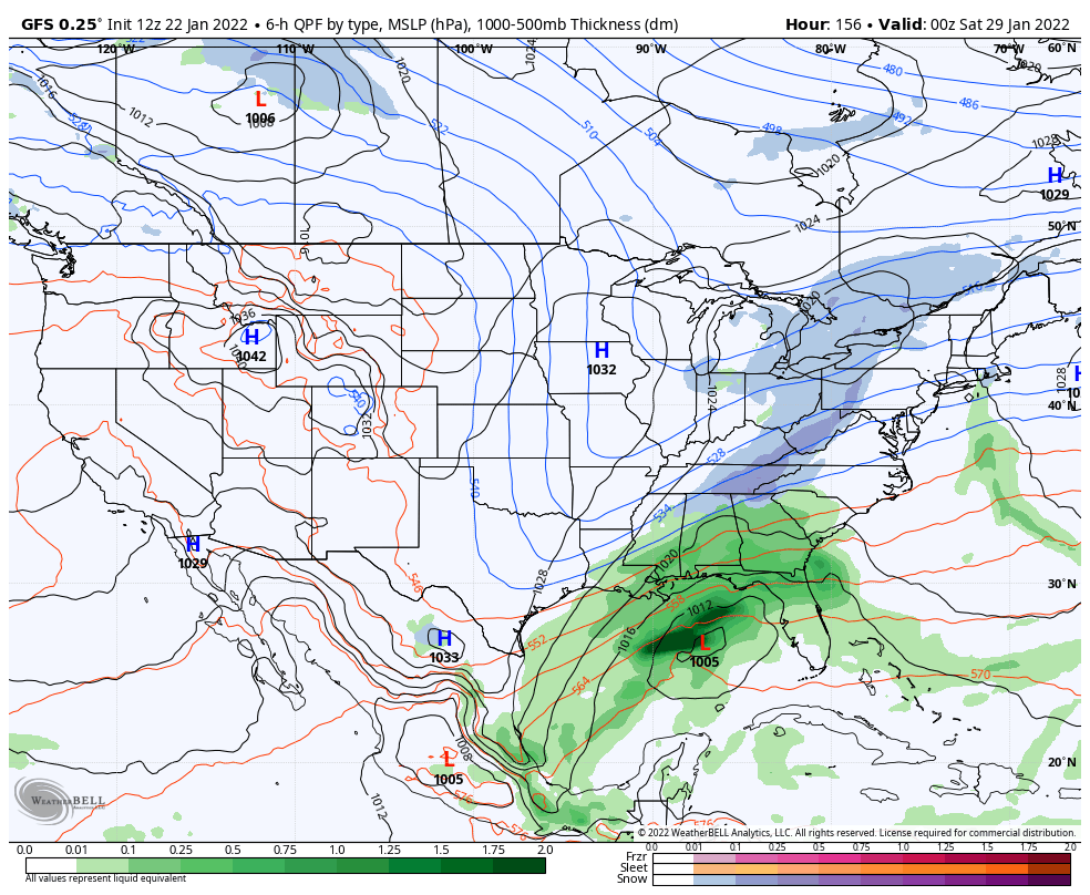
WINTRY MISCHIEF ON FRIDAY???: The GFS has swapped back to a wet solution on Friday as a cold front will move through the area. Showers will be possible during the late morning through the remainder of the day, and with a deep trough digging in behind the system, we look to have a changeover to snow. The European has now dropped the idea of any rain or snow on Friday, as it is painting a moisture-starved front. As you remember, this is completely the opposite of what I showed in this morning’s video. We’ll keep an eye on it to see if we need to put bread and milk on our grocery lists.
Category: Alabama's Weather, ALL POSTS, Winter Weather
About the Author (Author Profile)
Scott Martin is an operational meteorologist, professional graphic artist, musician, husband, and father. Not only is Scott a member of the National Weather Association, but he is also the Central Alabama Chapter of the NWA president. Scott is also the co-founder of Racecast Weather, which provides forecasts for many racing series across the USA. He also supplies forecasts for the BassMaster Elite Series events including the BassMaster Classic.Subscribe
If you enjoyed this article, subscribe to receive more just like it.


