Midday Nowcast: Sun to the North, Clouds to the South
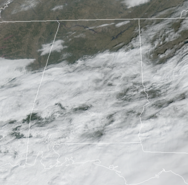
Northern portions of Alabama are mainly sunny, while clouds are covering the southern two-thirds of the state as the wave or low pressure tracks across the northern Gulf of Mexico. Most of the rain today has continued to be across southern portions of the state, and along the Gulf Coast.
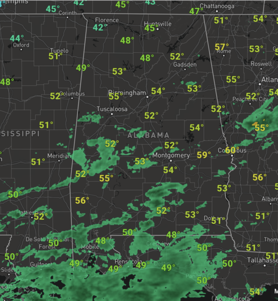
For the rest of us, we are either seeing clouds or sun, and we are dry. Temperatures today are generally in the lower 50s. Tonight we should see lows fall into the mid and upper 20s for North/Central Alabama under a mainly clear sky.
ACROSS THE USA: The next few days will overall be tranquil across the Lower 48 with no major storm systems. Temperatures will mainly be below normal in the Eastern two-thirds of the U.S., locally heavy snow is expected in the central and southern Rockies and High Plains, showers and thunderstorms are possible along the Gulf Coast into Florida and air stagnation issues are likely to persist in the Northwest.
REST OF THE WEEK: After the cold start tomorrow, the day will be sunny and cold with a high in the mid 40s. Dry and sunny weather continues Thursday with highs in the mid 50s. Clouds return to Alabama on Friday ahead of a cold front and upper trough. The models agree that the front will be moisture starved, with just clouds and no rain as it pushes through the state. However, there could be a few sprinkles, but most of Alabama will remain dry. Temperatures Friday will be in the upper 40s.
THE ALABAMA WEEKEND: More cold air for the weekend…Saturday morning looks to feature teens and lower 20s again across the northern half of Alabama, with highs in the low to mid 40s, despite sunshine in full supply. Sunday will be a mostly sunny day with a high in the lower 50s, after start the day in the mid 20s.
NEXT WEEK: Monday and Tuesday will be dry, and we could see a chance of rain Wednesday or Thursday. Highs to start the week should be in the 50s, but a pattern change next week suggest a warming trend with 60s returning by midweek.
BEACH FORECAST CENTER: Get the latest weather and rip current forecasts for the beaches from Fort Morgan to Panama City on our Beach Forecast Center page. There, you can select the forecast of the region that you are interested in visiting.
WORLD TEMPERATURE EXTREMES: Over the last 24 hours, the highest observation outside the U.S. was 109.8F at Learmonth Airport, Australia. The lowest observation was -65.0F at Delyankir, Russia.
CONTIGUOUS TEMPERATURE EXTREMES: Over the last 24 hours, the highest observation was 81F at Palm Springs, CA. The lowest observation was -31F at Crane Lake, MN.
WEATHER ON THIS DATE IN 1821: The Hudson River was frozen solid during the midst of the coldest winter in forty-one years. Thousands of persons crossed the ice from New York City to New Jersey, and refreshment taverns were set up in the middle of the river to warm pedestrians.
Category: Alabama's Weather, ALL POSTS
About the Author (Author Profile)
Macon, Georgia Television Chief Meteorologist, Birmingham native, and long time Contributor on AlabamaWX. Stormchaser. I did not choose Weather, it chose Me. College Football Fanatic. @Ryan_StinnetSubscribe
If you enjoyed this article, subscribe to receive more just like it.


