Midday Nowcast: A Blast of Winter Tonight and Tomorrow
The cold front continues to rush south through the state this afternoon and in its wake, we are dealing with increasing north winds at 15-25 mph and cold temperatures. Many locations are holding in the 40s this afternoon. There are a few snow showers over northern portions of the state, but no issues are expected. The sky is slowly clearing across the state this afternoon.
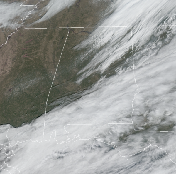
FRIGID NIGHT: A blast of winter air arrives overnight, and this will likely be one of the coldest nights this winter. The sky clears tonight, temperatures will fall into the upper teens and lower 20s, add in gusty north winds, and wind chill values are expected to be in the single digits for many locations to start the day.
COLD SATURDAY: Tomorrow will be sunny and cold with highs in the upper 30s and lower 40s and again, it will remain breezy, keeping wind chills below freezing all day. Finally the winds will relax Saturday night and Sunday morning lows again fall into the the low 20s, but the day will be warmer with highs returning to the 50s.
NEXT WEEK: Monday and Tuesday will be mostly sunny, dry days with a highs around 60 degrees. Then rain and storms looks to return for Wednesday and Thursday. Some strong storms may be possible, but still way too early to know, so a lot to watch in the coming days. Expect dry and colder to return to end the week and into the first weekend of February. Stay warm this weekend!!!
BEACH FORECAST CENTER: Get the latest weather and rip current forecasts for the beaches from Fort Morgan to Panama City on our Beach Forecast Center page. There, you can select the forecast of the region that you are interested in visiting.
WORLD TEMPERATURE EXTREMES: Over the last 24 hours, the highest observation outside the U.S. was 111.2F at Mariental, Namibia. The lowest observation was -67.4F at Yurty, Russia.
CONTIGUOUS TEMPERATURE EXTREMES: Over the last 24 hours, the highest observation was 83F at West Kendall-Tamiami, FL. The lowest observation was -36F at Peter Sinks, UT.
WEATHER ON THIS DATE IN 1922: The “Knickerbocker” storm immobilized the city of Washington D.C. The storm produced 28 inches of snow in 32 hours, and the heavy snow caused the roof of the Knickerbocker movie theatre to collapse killing 96 persons.
Category: Alabama's Weather, ALL POSTS
About the Author (Author Profile)
Macon, Georgia Television Chief Meteorologist, Birmingham native, and long time Contributor on AlabamaWX. Stormchaser. I did not choose Weather, it chose Me. College Football Fanatic. @Ryan_StinnetSubscribe
If you enjoyed this article, subscribe to receive more just like it.


