

Midday Nowcast: Clouds Increase Later Today

It was another chilly start to the day, but again we are warming up into the 60s this afternoon. Clouds will be increasing later today and tonight as the storm system to our west starts to develop bringing big changes to Alabama the rest of this week.
NORTH OF ALABAMA: Winter Storm Watches have been upgraded to Winter Storm Warnings and we are likely going to see some Ice Storm Warnings as a major winter storm will unfold from Texas northern New England over the next few days; heaviest snow will fall across parts of Missouri, Illinois, and Indiana… freezing rain and ice accumulation is possible as far south as Arkansas and West Tennessee. This wintry precipitation will stay just north of Alabama.
FOR ALABAMA: Tomorrow will be a cloudy day with scattered areas of rain as moisture surges north from the Gulf of Mexico and our winds increase to 15-25 mph. Highs tomorrow will range from the upper 50s to upper 60s. Periods of rain will continue through tomorrow night as the southerly flow persist.
Thursday will feature scattered showers, and temperatures will warm into the 70s as a warm front surges north ahead of an approaching cold front. As the cold front moves into the state, widespread rain and some thunderstorms are expected late Thursday and Thursday night. The SPC has introduced a low end “marginal risk” (level 1/5) of severe thunderstorms for Southwest Alabama, and I would not be surprised to see this risk area extended eastward across much of South Alabama in the coming days.
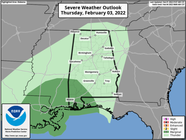
Storms there could produce strong gusty winds, with a possible brief isolated tornado, but for now most of Alabama will avoid the severe weather threat.
Heavy rainfall is in the forecast with rain amounts of 1-4 inches between tomorrow and Friday; some minor flooding issues could occur, but widespread flooding problems are not expected. The rain and storms begin to shift down into South Alabama late Thursday night and Friday morning. Much colder air returns Friday; some North Alabama communities will hover in the upper 30s and low 40s with a brisk north wind.
THE ALABAMA WEEKEND: Saturday looks like a mostly cloudy, cool day with a high in the upper 40s to low 50s. A wave of low pressure will track along the Gulf Coast Saturday night and Sunday, therefore we will bring widespread rain back in the forecast for this time period. Expect a cloudy and wet Sunday with highs again near 50°.
NEXT WEEK: The temperatures next week look to remain below average…highs in the 50s, lows in the 30s. For now, much of next week looks dry, but of course that could change in future forecasts.
BEACH FORECAST CENTER: Get the latest weather and rip current forecasts for the beaches from Fort Morgan to Panama City on our Beach Forecast Center page. There, you can select the forecast of the region that you are interested in visiting.
WORLD TEMPERATURE EXTREMES: Over the last 24 hours, the highest observation outside the U.S. was 110.7F at Learmonth Airport, Australia. The lowest observation was -49.0F at Habardino, Russia.
CONTIGUOUS TEMPERATURE EXTREMES: Over the last 24 hours, the highest observation was 83F at Linn, TX. The lowest observation was -32F at Clayton Lake, ME.
Category: Alabama's Weather, ALL POSTS
About the Author (Author Profile)
Macon, Georgia Television Chief Meteorologist, Birmingham native, and long time Contributor on AlabamaWX. Stormchaser. I did not choose Weather, it chose Me. College Football Fanatic. @Ryan_StinnetSubscribe
If you enjoyed this article, subscribe to receive more just like it.


