Midday Nowcast: Some Severe Storms Possible Today
A MESS TO OUR NORTH AND WEST: A major winter storm is ongoing across the eastern half of U.S. today producing rain, snow, and icy conditions, from New Mexico to Maine, but also will be bringing a threat for some strong to severe storms to Alabama later today.
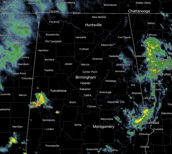
Scattered showers have been ongoing this morning across a lot of the state, and we are seeing temperatures surge well into the 60s and 70s.
STORM THREAT: A strong cold front has been holding just to our northwest this morning, but as it begins to dive south and east, it will bring more widespread rain and storms to Alabama, and some of these storms could be strong and locally severe.
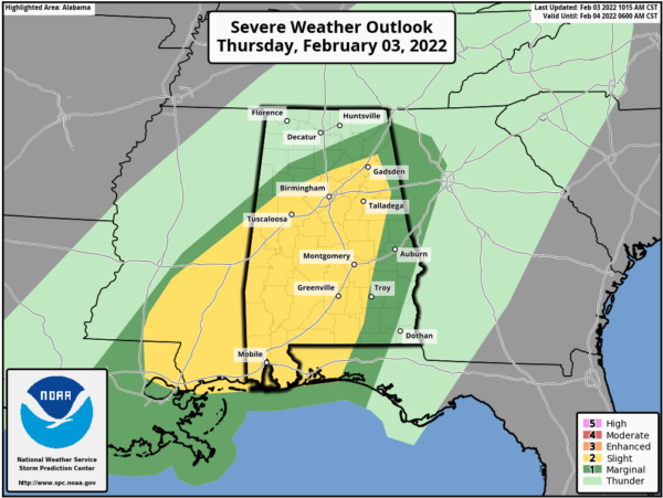
The SPC has expanded the severe weather risk and the level 2/5 “slight risk” includes much of Alabama now, including Tuscaloosa, Birmingham, Gadsden, and Anniston, and locations to the south.
Between now and 8PM is when most of Central Alabama should deal with the storms. The main threat will be in the form of strong straight line winds, but an isolated tornado or two is very possible within the “slight risk” area, especially south of Birmingham. At the writing on this forecast, late this morning, the SPC was preparing a tornado watch to be issued for portions of Mississippi and Southwest Alabama.

Along with the storm threat, heavy rainfall is expected as well and the flood watch remains in effect for roughly the northern half of Alabama today and tonight. Additional rain amounts of 1-3 inches are likely…keep in mind many spots had over one inch of rain yesterday. Again, stay weather aware the rest of today, and make sure you can receive and hear severe weather watches and warnings today if they become necessary later today.
FOUL FRIDAY: Winter returns as the cold pushes southward through the state tonight allow for much colder air to flow into the state. Most places from I-20 north will hold in the 30s all day, with 40s for South Alabama. There could be a brief period of light freezing rain or drizzle over some northern counties early tomorrow morning; for now no major or widespread impact is expected, but we will be watching for any signs of bridge icing. Rain will end early in the day over the northern counties, and showers tomorrow afternoon will shift into South Alabama before ending tomorrow night.
THE ALABAMA WEEKEND: We have removed the rain chance for the weekend as both Saturday and Sunday will feature a mix of sun and clouds. Highs Saturday will be cold and hold in the 40s, while mid 50s return on Sunday
NEXT WEEK: The temperatures next week look to near average…highs in the 50s, lows in the 30s. For now, much of next week looks dry as well.
BEACH FORECAST CENTER: Get the latest weather and rip current forecasts for the beaches from Fort Morgan to Panama City on our Beach Forecast Center page. There, you can select the forecast of the region that you are interested in visiting.
WORLD TEMPERATURE EXTREMES: Over the last 24 hours, the highest observation outside the U.S. was 109.2F at Shark Bay Airport, Australia. The lowest observation was -54.2F at Concordia, Antarctica.
CONTIGUOUS TEMPERATURE EXTREMES: Over the last 24 hours, the highest observation was 86F at Falcon Lake, TX. The lowest observation was -45F at Willow City, ND.
WEATHER ON THIS DATE IN 1988: Arctic air continued to invade the central U.S. The temperature at Midland TX plunged from a record high of 80 degrees to 37 degrees in just three hours. Morning lows in the higher elevations of Wyoming were as cold as 38 degrees below zero. Heavy snow blanketed southwestern Colorado, with 16 inches reported at Steamboat Springs.
Category: Alabama's Weather, ALL POSTS, Severe Weather
About the Author (Author Profile)
Macon, Georgia Television Chief Meteorologist, Birmingham native, and long time Contributor on AlabamaWX. Stormchaser. I did not choose Weather, it chose Me. College Football Fanatic. @Ryan_StinnetSubscribe
If you enjoyed this article, subscribe to receive more just like it.


