Midday Nowcast: Lovely Valentine’s Day
Great weather highlights the forecast for the rest of today with tons of sunshine and after the morning chill, temperatures are in the low to mid 50s this afternoon. No weather issues if you are taking your Valentine out tonight, but with temperatures falling through the 40s, you’ll want to stay close to each other to keep warm. Tonight will be clear and cold with lows in the upper 20s to mid 40s.
WARMING TREND: Tomorrow will be sunny and warmer with highs in the mid 60s. Expect upper 60s on Wednesday with a few more clouds as a strong southerly flow develops ahead of our next storm system.
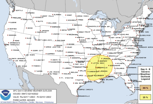
SEVERE STORMS POSSIBLE THURSDAY: Thursday will be a warm and breezy day with temperatures in the 70s ahead of a dynamic weather system that will bring the threat of strong to severe thunderstorms to Alabama Thursday. Shear and instability values look favorable, but the main upper air support will be lifting north of the region by mid to late afternoon, meaning the higher severe weather probabilities will be over Mississippi and the western half of Alabama. SPC has much of the state in a severe weather risk Thursday.
For now, it looks like all modes of severe weather will be possible, including strong straight-line winds, hail, and a few tornadoes. Rain amounts will likely be at or a little over one inch for most of the state, but widespread flooding issues are not expected as the system will move through the state rapidly. The main window for the heavier storms will come during the afternoon and evening hours.
FRIDAY AND THE WEEKEND: The sky becomes mostly sunny Friday, and the day will be cooler with a high in the low 50s. Dry weather continues over the weekend for most of Alabama with mostly sunny days and fair nights; the high Saturday will be in the upper-50s, followed by low-60s Sunday. Clouds will linger near the immediate Gulf Coast with some scattered light rain possible over the weekend.
NEXT WEEK: The warming trend continues; the high will be in the 60s Monday, low 70s Tuesday, and mid-70s Wednesday. The next weather system will bring a chance of rain and thunderstorms by Wednesday or Thursday…
BEACH FORECAST CENTER: Get the latest weather and rip current forecasts for the beaches from Fort Morgan to Panama City on our Beach Forecast Center page. There, you can select the forecast of the region that you are interested in visiting.
WORLD TEMPERATURE EXTREMES: Over the last 24 hours, the highest observation outside the U.S. was 108.0F at Roebourne, Australia. The lowest observation was -65.7F at Delyankir, Russia.
CONTIGUOUS TEMPERATURE EXTREMES: Over the last 24 hours, the highest observation was 91F at Santee, CA. The lowest observation was -28F at Wright, NM.
Category: Alabama's Weather, ALL POSTS
About the Author (Author Profile)
Macon, Georgia Television Chief Meteorologist, Birmingham native, and long time Contributor on AlabamaWX. Stormchaser. I did not choose Weather, it chose Me. College Football Fanatic. @Ryan_StinnetSubscribe
If you enjoyed this article, subscribe to receive more just like it.


