Midday Nowcast: Spring-Like Warmth Today; Spring-Like Storms Tomorrow
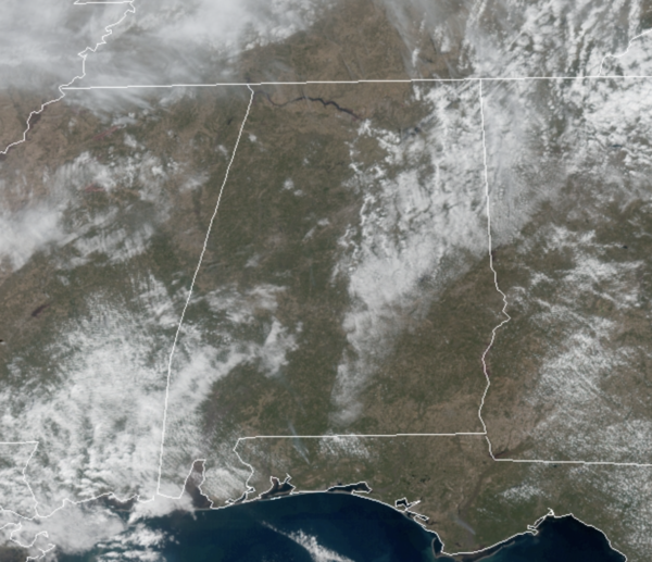
SPRING-LIKE: We are seeing a mix of sun and clouds across Alabama today, and overall warm conditions as temperatures are making a run towards the lower 70s in many locations. Our winds are a bit more breezy as well this afternoon, out of the south at 10-20 mph. Tonight, expect increasing clouds with lows in the low to mid 60s.
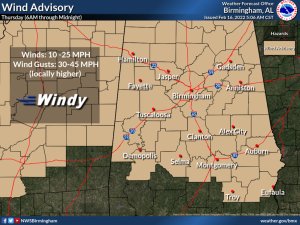
WARM, WINDY THURSDAY: Tomorrow will be a warm day with highs in the low to mid 70s, and most of the day should be dry. It will be a windy day as gradient winds (not related to thunderstorms) will average 15-30 mph out of the south, with potential for gusts to 45 mph.
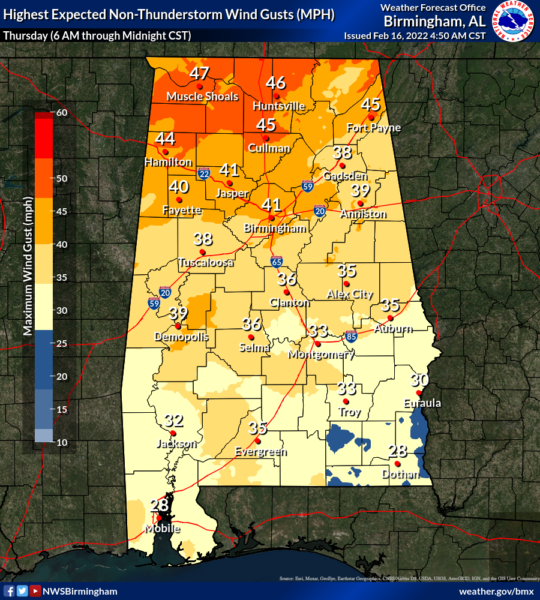
These alone can cause tree and power issues, and for that reason, most of Alabama is under a Wind Advisory for all of tomorrow.
To out west, a dynamic weather system will cause a line of strong to severe storms will develop ahead of a cold front and these storms will move into Northwest Alabama by early afternoon and will continue to move through the state during the afternoon, evening and overnight hours.
PLACEMENT: The SPC has increased portions of Alabama to an “enhanced risk” (level 3/5) of severe storms, west of a line from Huntsville to Birmingham to Demopolis; while a “slight risk” (level 2/5) defined for areas west of a line from Centre to Anniston to Rockford to Camden to Jackson; the rest of the state is in a “marginal risk” (level 1/5).
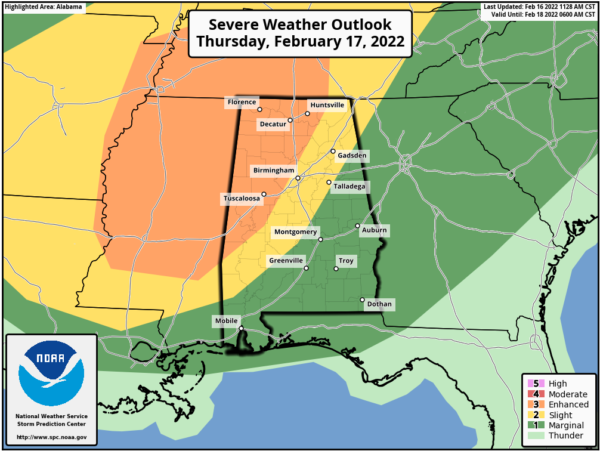
TIMING: For now, the main window for severe storms in Alabama will come from 2PM in Northwest Alabama through 2AM in Southeast Alabama. For places like Birmingham, Tuscaloosa, Anniston, and Gadsden, the core threat comes through the evening hours, 5PM-9PM.
THREATS: There will be ample shear in place, but we note the main dynamics will be racing off to the northeast. Also, instability values will not be overly impressive, but there is still plenty of fuel for the storms. If instability values are higher, the threat could be greater tomorrow. Storms will be capable of producing hail, strong winds, and a few tornadoes. The higher risk of a tornado is over the “enhanced risk” across the western and northern portions of Alabama. However, don’t for focus on colors on the map, just note that all of Alabama under a risk for severe storms tomorrow.
RAIN: Rain amounts of around one inch are likely, but flooding is not expected to be an issue for now as the system will be moving very quickly through the state.
CALL TO ACTION: Again, this is not uncommon for this time of year…Be prepared and make sure you have all aspects of your severe weather safety plan ready for action. Be sure you have a way of hearing severe weather warnings, and an action plan if you are in a tornado warning polygon, take severe thunderstorm warnings seriously too. Have a NOAA Weather Radio in your home and business, properly programmed with a fresh battery in case of power failure. Be sure WEA (Wireless Emergency Alerts) enabled on your phone…this is not an app, but built into every phone sold in the U.S. Check settings, and notifications, and be sure emergency alerts are on. Have the free ABC 33/40 weather app on your phone as a secondary way of getting warnings. Search the App Store for “ABC 33/40 Weather” if you don’t have it already.
In a site built home, identify the safe place. Small room, lowest floor, near the center of the house, away from windows. And, in that safe place, have helmets for everyone in the family (including adults!), portable air horns, and hard sole shoes. You CANNOT stay in a mobile home if you are in a tornado warning polygon. Know the closest shelter, and how to get there quickly.
Sheltering from a tornado is first priority when it comes to the COVID-19 situation. A tornado is an immediate threat to life; get to your safe place or shelter and do the best you can to protect yourself from exposure to the virus.
FRIDAY AND THE WEEKEND: The sky becomes sunny Friday, and the day will be cooler with a high in the low 50s. Dry weather continues over the weekend for most of Alabama with mostly sunny days and fair nights; the high Saturday will be in the mid 50s, followed by mid 60s Sunday.
NEXT WEEK: Much of next week looks rather wet at times, with rain amounts in the 1-2 inch range look likely Monday through Friday. Too early to know if we will see any severe weather threat. The week will be mild as temperatures most days will reach the 70s in many places.
BEACH FORECAST CENTER: Get the latest weather and rip current forecasts for the beaches from Fort Morgan to Panama City on our Beach Forecast Center page. There, you can select the forecast of the region that you are interested in visiting.
WORLD TEMPERATURE EXTREMES: Over the last 24 hours, the highest observation outside the U.S. was 109.2F at Carnarvon, Australia. The lowest observation was -65.2F at Delyankir, Russia.
CONTIGUOUS TEMPERATURE EXTREMES: Over the last 24 hours, the highest observation was 89F at Rio Grande Village, TX. The lowest observation was -24F at Estcourt Station, ME.
Category: Alabama's Weather, ALL POSTS
About the Author (Author Profile)
Macon, Georgia Television Chief Meteorologist, Birmingham native, and long time Contributor on AlabamaWX. Stormchaser. I did not choose Weather, it chose Me. College Football Fanatic. @Ryan_StinnetSubscribe
If you enjoyed this article, subscribe to receive more just like it.


