Mesoscale Discussion — Tornado Threat Continues Across the Area Into the Evening Hours
SUMMARY… The evolution of one or two supercells posing a risk to produce tornadoes remains possible into the 6-8 PM CST time frame.
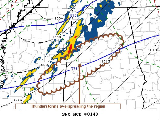
DISCUSSION… As a low amplitude surface low migrates across north central Kentucky into southern Ohio through early evening, pre-frontal low-level flow will continue to gradually veer to more of a westerly component across the lower Mississippi Valley into the southern Appalachians. This already appears to be allowing for an east-northeastward advection of deeper boundary-layer moisture, roughly along the Interstate 20 corridor of southern Mississippi into central Alabama, where associated destabilization may coincide with low-level wind profiles exhibiting at least modest veering with height and strong speed shear. This may provide the primary focus for the potential development of one or two sustained supercells posing a risk for tornadoes into the 00-02Z time frame, just ahead of the southeastward advancing cold front in the wake of the surface low. With the approach of the front, low-level wind profiles are forecast to become more linear and the strong wind gusts with consolidating convection along it may become the primary severe hazard.
Category: Alabama's Weather, ALL POSTS, Severe Weather
About the Author (Author Profile)
Scott Martin is an operational meteorologist, professional graphic artist, musician, husband, and father. Not only is Scott a member of the National Weather Association, but he is also the Central Alabama Chapter of the NWA president. Scott is also the co-founder of Racecast Weather, which provides forecasts for many racing series across the USA. He also supplies forecasts for the BassMaster Elite Series events including the BassMaster Classic.Subscribe
If you enjoyed this article, subscribe to receive more just like it.


