Weather Xtreme — Great & Warm Weather Today; Severe Storms Possible on Monday
THIS WEEKEND: We’ll have great and warm weather across Central Alabama today, as skies will be mainly sunny. It will be a great day to get out there and do some outdoor activities. Afternoon highs will top out in the mid 70s to the lower 80s.
Unfortunately, our streak of dry weather will come to an end on Sunday as clouds will begin to build and some showers and maybe a few thunderstorms look to move into the western parts of the area by the afternoon hours. At this point, all of the activity will stay well west of the I-65 corridor, and the eastern half of the area may see plenty of sunshine. Highs will be in the mid 70s to the mid 80s.
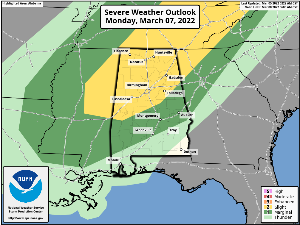
SEVERE STORMS POSSIBLE ON MONDAY: A frontal boundary will be moving into and through the area on Monday that will bring rain and storms, some of which could be strong to severe, mainly during the afternoon and evening hours. At this point, much of the activity looks to be associated with a squall line, but we’ll have a better look once the higher-resolution models come into view.
A Slight Risk for severe storms is up for all of North Alabama and stretches into Central Alabama down to a line from just south of Demopolis to Clanton to Fruithurst. A Marginal Risk is up for nearly the rest of Central Alabama, except for locations south of a line from Stills Crossroads (Pike Co.) to Phenix City (Russell Co). All modes of severe weather will be possible, but the overall tornado threat looks to be low at this point. Highs will be in the mid 70s to the mid 80s across the area.
THE REST OF NEXT WEEK: Another shortwave will move across Central Alabama on Tuesday that will bring showers and thunderstorms back into the forecast during the afternoon and evening hours. At this point, severe weather doesn’t look likely, but we’ll keep our eyes on it. Highs will be in the upper 50s to the lower 70s. Finally, the rain and storms will push out of Central Alabama by midday on Wednesday, giving us a chance to dry out for a few days. Skies will be mostly cloudy and highs will be in the upper 50s to the lower 70s.
Thursday will be a nice day across the area with partly sunny skies. Highs will be in the mid 60s to the lower 70s. We do see that moisture will begin to build across the area on Friday, but the good news is that rain looks to hold off until the late-night and overnight hours. Skies will be partly sunny, with highs in the mid 60s to the mid 70s.
Category: Alabama's Weather, ALL POSTS, Severe Weather, Weather Xtreme Videos
About the Author (Author Profile)
Scott Martin is an operational meteorologist, professional graphic artist, musician, husband, and father. Not only is Scott a member of the National Weather Association, but he is also the Central Alabama Chapter of the NWA president. Scott is also the co-founder of Racecast Weather, which provides forecasts for many racing series across the USA. He also supplies forecasts for the BassMaster Elite Series events including the BassMaster Classic.Subscribe
If you enjoyed this article, subscribe to receive more just like it.


