Weather Xtreme — Mainly Dry & Warm Today; Strong to Severe Storms Possible on Monday
TODAY’S WEATHER: Today will be a decent day for the most part across Central Alabama, so get out there and enjoy the last day before rainy weather sets in for a few days. Skies will be partly to mostly cloudy across the area, and there is a very small chance of a few showers for the extreme western portions. Today’s highs will reach the upper 70s to the mid 80s. More clouds and showers will move in late tonight and through the overnight hours west of I-65. Lows will be in the upper 50s to the mid 60s.
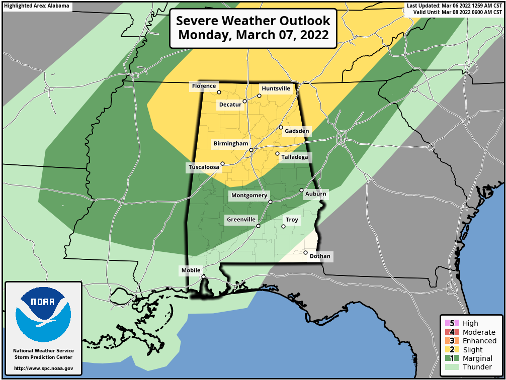
MONDAY’S SEVERE WEATHER THREAT: A cold front will be moving into and through the area on Monday that will bring rain and storms, some of which could be strong to severe. Once again, much of the activity looks to be associated with a squall line with light to moderate rain falling behind it.
A Slight Risk for severe storms is up for all of North Alabama and stretches into Central Alabama down to a line from Aliceville to Clanton to Heflin. A Marginal Risk is up for nearly the rest of Central Alabama, except for locations south of a line from Macedonia (Montgomery Co.) to Phenix City (Russell Co). All modes of severe weather will be possible, but the overall tornado threat looks to be low at this point.
The main window for the threat of severe storms will be from 9 am in the northwestern parts of the area and coming to an end in the southeastern parts by around 9 pm. Highs will be in the lower 70s to the mid 80s across the area.
THE REST OF THE WORK WEEK: Another shortwave will move across Central Alabama on Tuesday that will bring showers and thunderstorms back into the forecast during the afternoon and evening hours. At this point, severe weather doesn’t look likely, but we’ll keep our eyes on it. Highs will be in the upper 50s to the lower 70s. Rain and storms will push out of Central Alabama by midday on Wednesday, giving us a small break until more rain moves back into the southern parts of the area by the evening hours. Skies will be mostly cloudy and highs will be in the upper 50s to the lower 70s. Thursday will start off with showers and storms across the area, but much of the activity will be out of the area by the late afternoon hours. Highs will be in the upper 60s to the mid 70s.
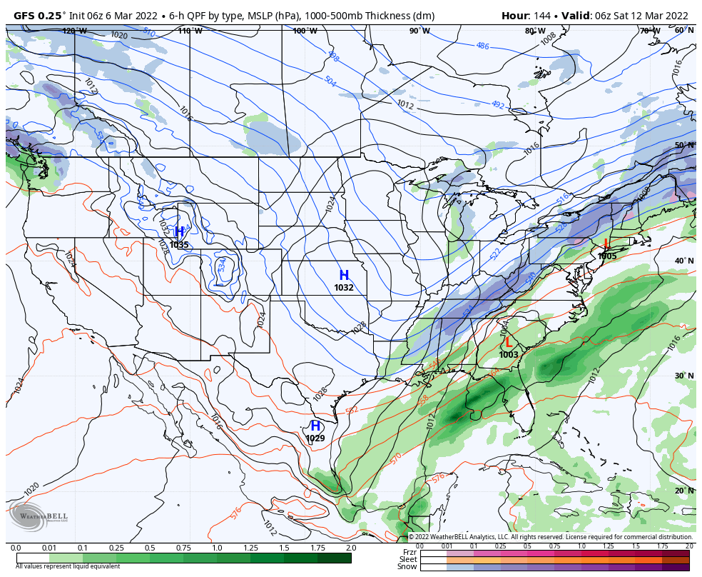
A deep trough will begin to push into the southeast on Friday that will bring us more clouds and showers late into the day. Much colder air will be moving in with this activity, and the GFS is actually painting a little bit of snow activity with it during the late night through the overnight hours. Lows will get down into the upper 20s to the upper 30s across the area, but after highs reaching the lower 60s to the mid 70s, the ground will be way too warm for any accumulations.
THE NEXT CENTRAL ALABAMA WEEKEND: Next weekend will be much cooler as the trough settles in on Saturday, with showers coming to an end early in the day. Skies will start to clear out and dry weather settles in for the remainder of the weekend. Sunday will be a beautiful day with plenty of sunshine. Highs will be in the mid 40s to the mid 50s on Saturday, and in the mid 50s to the lower 60s on Sunday.
Category: Alabama's Weather, ALL POSTS, Severe Weather, Weather Xtreme Videos, Winter Weather
About the Author (Author Profile)
Scott Martin is an operational meteorologist, professional graphic artist, musician, husband, and father. Not only is Scott a member of the National Weather Association, but he is also the Central Alabama Chapter of the NWA president. Scott is also the co-founder of Racecast Weather, which provides forecasts for many racing series across the USA. He also supplies forecasts for the BassMaster Elite Series events including the BassMaster Classic.Subscribe
If you enjoyed this article, subscribe to receive more just like it.


