Late Sunday Night Look at Monday’s Severe Weather Threat
The forecast continues to show the threat of a few severe storms over Central Alabama during the day on Monday, as a cold front will be moving through the area. However, the line is projected to move in a little earlier during the morning and will exit the area earlier in the evening. Therefore, the timing has been adjusted on the forecast.
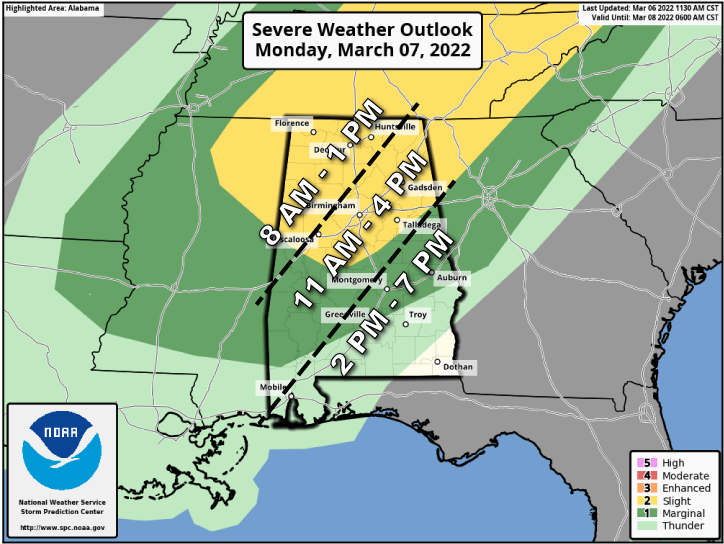
A Slight Risk for severe storms continues for all of North Alabama and stretches into Central Alabama down to a line from Aliceville to Clanton to Heflin. A Marginal Risk is up for nearly the rest of Central Alabama, except for locations south of a line from Macedonia (Montgomery Co.) to Phenix City (Russell Co).
In the slight risk area, damaging winds up to 60 mph, quarter size hail, and a brief spin-up tornado will be possible. In the marginal risk area, the main threats will be from isolated damaging wind gusts up to 60 mph and quarter size hail.
The main window for the threat of severe storms will now be from roughly 8 am to 1 pm in the north and northwestern parts of the area, from 11 am to 4 pm for the northeast, central, and southwestern parts of the area, and from 2 pm to 7 pm for the south and southeastern parts of the area.
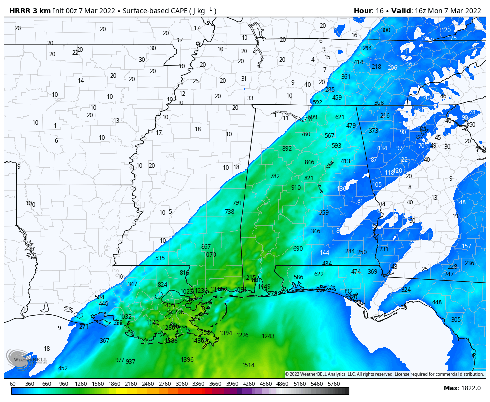
00z HRRR CAPE (surface-based instability) valid Monday at 10 am.
Here is a quick breakdown… As the line moves into the northwestern parts of the area, that is where the greatest potential for damaging winds and a brief spin-up tornado looks to be. There will be plenty of instability (fuel for storm building and longevity) available out ahead and along the line of storms, and combine that with a decent amount of wind shear (the change of direction and speed with height) and helicity (the measure of the tendency for rotation in a storm’s updraft), damaging winds and a brief tornado will be possible.
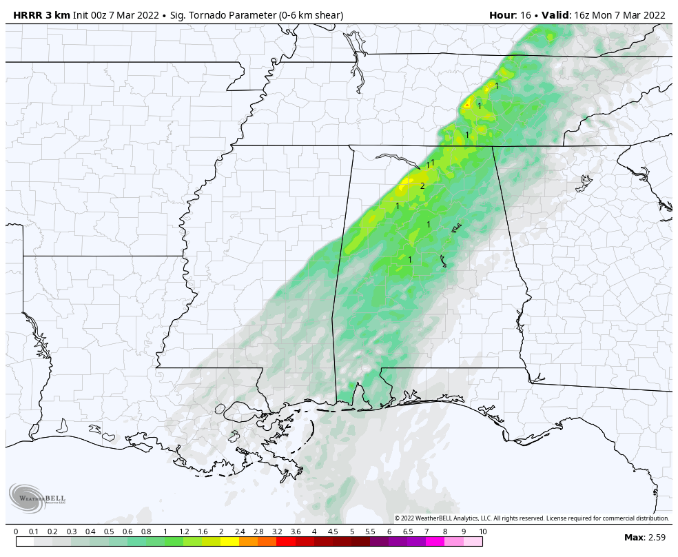
00z HRRR Significant Tornado Parameter valid Monday at 10 am.
The good news is that the overall tornado threat will be small as the Significant Tornado Parameter values remain around 2.0 or less throughout the event, and those numbers are mainly found just ahead and along the line of storms.
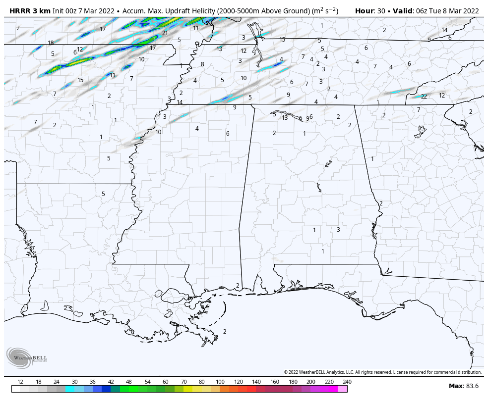
00z HRRR Updraft Helicity Tracks valid for the event ending Monday at midnight.
Also, the Updraft Helicity Tracks tool is not showing any rotating updrafts in the latest HRRR run. The best news of all is that the better dynamics associated with this system will be pulling farther off to the northeast as time moves on, meaning that the line will be weakening as it pushes farther through the area.
There will probably be more adjustments made to the risk levels by the SPC during the overnight model runs, and we could see the slight risk shifted. The timing of the threat of severe weather will be adjusted as the line gets closer and how it is trending on radar. Future upper air soundings will also give us a much better look at what type of atmosphere we’ll be dealing with.
I’ll be with you throughout the day with updates and with any severe weather watches or warnings being issued. James Spann will have your morning Weather Xtreme Video, and if the weather allows it, will be back with an afternoon video.
Category: Alabama's Weather, ALL POSTS, Severe Weather
About the Author (Author Profile)
Scott Martin is an operational meteorologist, professional graphic artist, musician, husband, and father. Not only is Scott a member of the National Weather Association, but he is also the Central Alabama Chapter of the NWA president. Scott is also the co-founder of Racecast Weather, which provides forecasts for many racing series across the USA. He also supplies forecasts for the BassMaster Elite Series events including the BassMaster Classic.Subscribe
If you enjoyed this article, subscribe to receive more just like it.


