Mesoscale Discussion — Isolated Severe Threat Continues; Watch Unlikely to be Issued
The severe weather threat remains to be isolated, and the SPC’s Mesoscale Discussion mentions that a severe weather watch is unlikely to be issued at this time. Here is the text from that discussion…
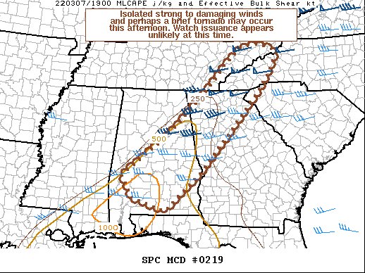
SUMMARY… Isolated strong to damaging winds and perhaps a brief tornado may occur this afternoon. Watch issuance appears unlikely at this time.
DISCUSSION… A line of shallow convection along/near a cold front will continue moving eastward across the Southeast this afternoon. While a moist low-level airmass is present ahead of this line across AL/GA, multiple inversions and poor lapse rates aloft are limiting instability, with MLCAPE mostly 750 J/kg or less across the warm sector. With additional modest diurnal heating this afternoon, MLCAPE has locally increased up to around 1000 J/kg across parts of southern AL. Enough deep-layer shear is present to support storm organization, but low-level flow is expected to continue weakening/veering as the primary upper trough moves northeastward and away from the Southeast. Still, in the short term, there may be a window of opportunity for isolated strong to damaging winds to occur with small bowing segments in the line. Occasional weak low-level rotation has also been noted with convective elements over the past couple of hours, and a brief tornado remains possible. The overall severe threat should remain rather isolated this afternoon.
Category: Alabama's Weather, ALL POSTS, Severe Weather
About the Author (Author Profile)
Scott Martin is an operational meteorologist, professional graphic artist, musician, husband, and father. Not only is Scott a member of the National Weather Association, but he is also the Central Alabama Chapter of the NWA president. Scott is also the co-founder of Racecast Weather, which provides forecasts for many racing series across the USA. He also supplies forecasts for the BassMaster Elite Series events including the BassMaster Classic.Subscribe
If you enjoyed this article, subscribe to receive more just like it.


