Midday Nowcast: Rain Increasing in Coverage
The front that brought the rain and storms yesterday is stalled across South Alabama today. A wave of low pressure is moving along this front and is spreading rain back north across Alabama as we roll into and through the afternoon hours.
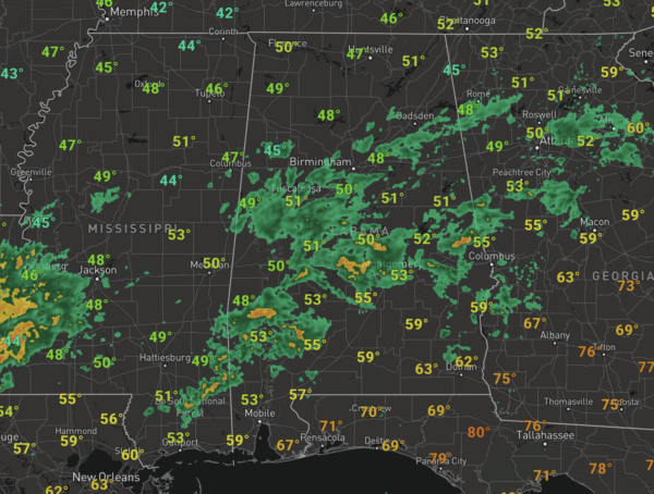
Widespread soaking rain will continue through tonight and into tomorrow. It remains cloudy and cool with temperatures in the 50s. The SPC maintains a risk of severe thunderstorms for portions of Southwest Alabama and Northwest Florida. A few storms in these areas could produce strong gusty winds.
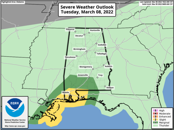
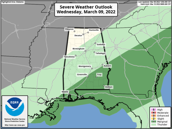
The rain will wind down tomorrow morning for most places, with most of the rain confined to half of Alabama, where the SPC has a ‘marginal risk” for severe storms tomorrow.
For the northern half of the state, it will remain cloudy with a high in the mid to upper 50s for most places. Rain will remain a threat for Southeast Alabama on Thursday, while the rest of the state should feature a mix of sun and clouds with a high back in the 60s.
FRIDAY FRONT: A sharp cold front will push into the state Friday. Ahead of the front, rain and storms will return to Alabama. Though temperatures should climb into the low 70s Friday, the more unstable air mass looks to remain across South Alabama, where there could be some severe storms. At this time, we are not expecting severe storms for North/Central Alabama.
WINTER RETURNS: Behind the front, much colder blows into Alabama Friday night. There is a chance the rain changes to snow before ending over the northern third of the state (generally from I-20 north). It is the classic situation where cold air is chasing moisture on the back side of a departing storm system, and generally this isn’t a setup for really meaningful accumulation. But, the grass could turn white in a few spots across North Alabama after midnight Friday night into early Saturday morning. Temperatures will drop to or just below freezing early Saturday morning, but for now travel impacts aren’t expected.
For Saturday, the sky will clear during the day and it will be cold and windy with temperatures in the 30s and 40s across North/Central Alabama. Add in a blustery north wind, and wind chills will be closer to freezing much of the day.
SUNDAY MORNING FREEZE: A significant freeze is in the forecast Sunday morning, with lows in the 20-26 degree range for most places over the northern half of the state. Upper 20s and lower 30s are expected as far south as the Gulf Coast. After the morning freeze, Sunday will be a sunny day and a bit warmer with highs in the 50s.
NEXT WEEK: The weekend cold snaps looks to exit quickly as highs return to the 60s on Monday. For now, the rest of the week looks dry with a warming trend… temperatures reach the 70s by midweek.
BEACH FORECAST CENTER: Get the latest weather and rip current forecasts for the beaches from Fort Morgan to Panama City on our Beach Forecast Center page. There, you can select the forecast of the region that you are interested in visiting.
WORLD TEMPERATURE EXTREMES: Over the last 24 hours, the highest observation outside the U.S. was 112.5F at Ndjamena, Chad. The lowest observation was -82.5F at Concordia, Antarctica.
CONTIGUOUS TEMPERATURE EXTREMES: Over the last 24 hours, the highest observation was 91F at Plant City, FL. The lowest observation was -25F at Grand Lake, CO.
Category: Alabama's Weather, ALL POSTS
About the Author (Author Profile)
Macon, Georgia Television Chief Meteorologist, Birmingham native, and long time Contributor on AlabamaWX. Stormchaser. I did not choose Weather, it chose Me. College Football Fanatic. @Ryan_StinnetSubscribe
If you enjoyed this article, subscribe to receive more just like it.


