Rain Pushing Through the Birmingham Metro; No Severe & No Snow Yet
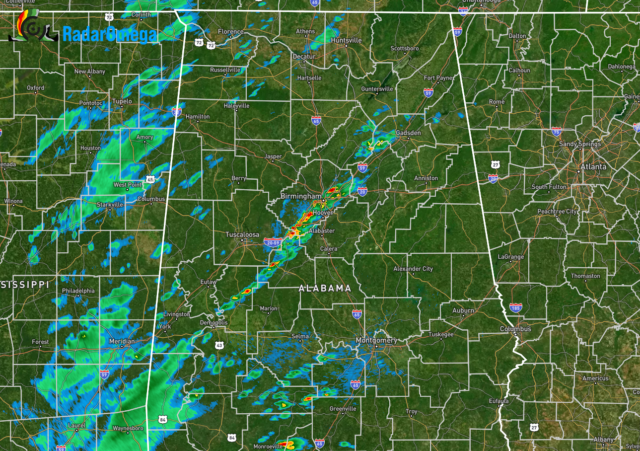
At 8:06 pm this evening, rain is pushing through the Birmingham metropolitan area, with some heavier downpours mixed in. There are two bits of good news… The first is that none of this action is strong or severe… The second is that temperatures are still well above freezing, sitting at 63º at the Birmingham International Airport.
We also have some lighter showers crossing over the state line from Mississippi, and we’ll have to start watching the northwest corner of North/Central Alabama as the cold front is working through that area and has pushed temperatures down into the mid to upper 40s.
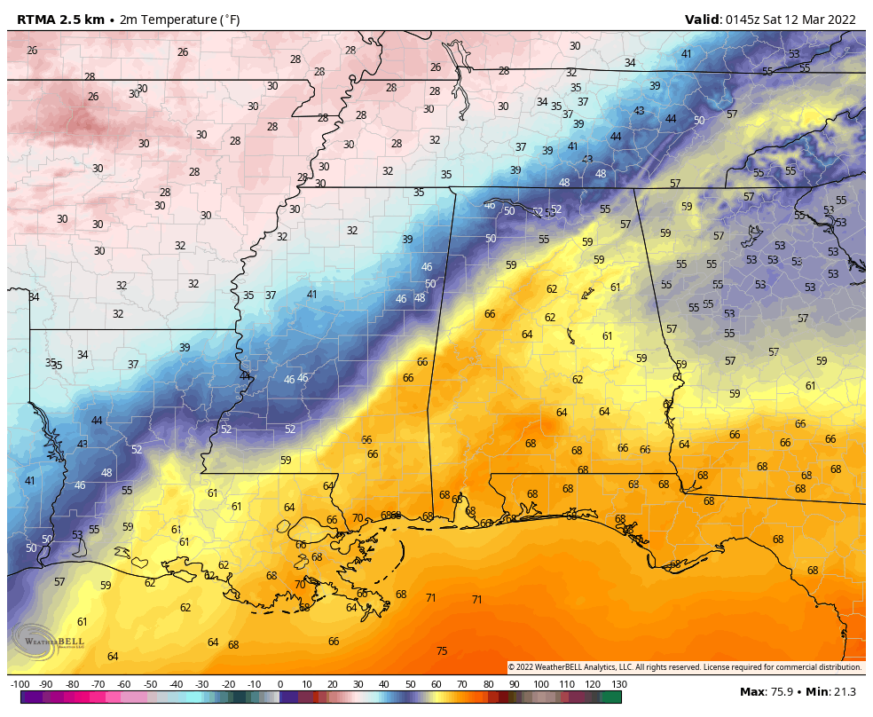
The last run of the RTMA Temperature Readings show the cold front was stretching from near Scottsboro in Jackson County back to the southwest through Cullman and back into Reform in Pickens County. Temperatures out ahead of the front were in the upper 50s to the mid 60s, while behind the front, we are seeing upper 30s to the mid 50s from northwest to southeast.
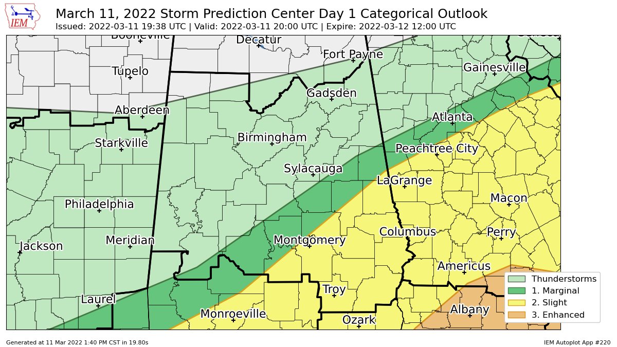
A Slight Risk for severe storms continues for locations south of a line from Lowndesboro (Lowndes Co.) to Roanoke (Randolph Co.), which includes the cities of Auburn, Eufaula, Montgomery, and Troy. A Marginal Risk continues north of that to as far north as Sweet Water (Marengo Co.) to Clanton (Chilton Co.) to Ranburne (Cleburne Co.), which includes the cities of Alexander City and Selma.
Here is the latest Hazardous Weather Outlook from NWS Birmingham:
DAY ONE… Outlook through Tonight.
Strong to severe thunderstorms are possible from 9 PM tonight through 3 AM Saturday, generally near and south of the Interstate 85 corridor. The primary threat will be damaging winds up to 60 mph, but a tornado is also possible.
Rain is expected to mix with or change over to snow and sleet tonight into Saturday morning for part of Central Alabama. Light accumulations are expected, generally near and north of Interstate 20. Total snow and sleet accumulations of up to 2 inches, with locally higher amounts, are possible for counties in the Winter Storm Warning, and up to 1 inch with locally higher amounts for counties in the Winter Weather Advisory.
Breezy conditions will occur tonight and Saturday. Northwest winds of 15 to 25 mph with gusts up to 40 mph are expected across Central Alabama.
Temperatures are forecast to drop below freezing across portions of Central Alabama tonight. Precautions should be taken to protect vulnerable populations, outdoor pets, and sensitive vegetation.
DAYS TWO THROUGH SEVEN… Saturday through Thursday.
Temperatures will continue to drop through the day on Saturday, falling into the lower 20s to upper teens by Sunday morning. Precautions should be taken to protect vulnerable populations, outdoor pets, and sensitive vegetation, and exposed pipes.
A WINTER STORM WARNING is in effect from midnight tonight until 9 am Saturday morning for Blount, Cherokee, Etowah, Marion, and Winston counties in Central Alabama.
A WINTER STORM WARNING is in effect from 9 pm tonight until 9 am Saturday morning for all counties in North Alabama.
A WINTER WEATHER ADVISORY is in effect from midnight tonight until 9 am Saturday morning for Bibb, Calhoun, Clay, Cleburne, Fayette, Greene, Hale, Jefferson, Lamar, Pickens, Shelby, St. Clair, Sumter, Talladega, Tuscaloosa, and Walker counties in Central Alabama.
A WIND ADVISORY will go into effect tonight at 10 pm until 6 pm Saturday evening for Autauga, Barbour, Bibb, Blount, Bullock, Calhoun, Chambers, Cherokee, Chilton, Clay, Cleburne, Coosa, Dallas, Elmore, Etowah, Fayette, Greene, Hale, Jefferson, Lamar, Lee, Lowndes, Macon, Marengo, Marion, Montgomery, Perry, Pike, Pickens, Randolph, Russell, Shelby, St. Clair, Sumter, Talladega, Tallapoosa, Tuscaloosa, Walker, and Winston counties in Central Alabama.
A WIND ADVISORY will go into effect tonight at 9 pm until 12 pm Saturday afternoon for Colbert, Cullman, DeKalb, Franklin, Jackson, Lauderdale, Lawrence, Limestone, Madison, Marshall, and Morgan counties in North Alabama.
A FREEZE WARNING will go into effect for all of the Central Alabama counties starting at midnight tonight and is currently set to expire at 9 am Sunday morning.
Category: Alabama's Weather, ALL POSTS, Severe Weather, Winter Weather
About the Author (Author Profile)
Scott Martin is an operational meteorologist, professional graphic artist, musician, husband, and father. Not only is Scott a member of the National Weather Association, but he is also the Central Alabama Chapter of the NWA president. Scott is also the co-founder of Racecast Weather, which provides forecasts for many racing series across the USA. He also supplies forecasts for the BassMaster Elite Series events including the BassMaster Classic.Subscribe
If you enjoyed this article, subscribe to receive more just like it.


