Tornado Watch Potentially Coming Soon to the Southeastern Parts of the Area
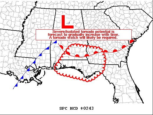
SUMMARY… Severe weather risk — including potential for a couple of
tornadoes — will gradually increase the remainder of this evening
and overnight. A tornado watch will likely be needed.
DISCUSSION… The latest water vapor loop shows a strong short-wave trough approaching the lower Mississippi Valley region at this time, and will reach the central Gulf Coast states and Tennessee Valley overnight. As this occurs, a surface cold front will continue advancing eastward, while a cold air dam persisting across the Carolinas and into Georgia/eastern Alabama gradually erodes with time from southwest to northeast.
As the low-level dam/stable layer is gradually replaced by higher theta-e air as low-level theta-e advection increases in tandem with the advance of the upper system, a more favorable thermodynamic environment — in terms of sustaining deep/moist convection — will slowly evolve. Initially, this increase in low-level theta-e — and thus mixed-layer CAPE — will occur from southern Alabama and the Florida Panhandle into southwestern Georgia. As this occurs, in tandem with a corresponding increase in low-level flow, risk for organized/rotating storms will likewise increase.
At this time, it appears that a combination of storms developing near the front, along with additional warm-sector cells spreading northeastward/onshore from the Gulf, will eventually contribute to the increase in severe risk. Along with the potential for a few instances of marginally severe hail, locally damaging wind gusts will be possible, as will a couple of tornadoes. As such, new Tornado Watch issuance is expected to be required in the next 1 to 2 hours.
Category: Alabama's Weather, ALL POSTS, Severe Weather
About the Author (Author Profile)
Scott Martin is an operational meteorologist, professional graphic artist, musician, husband, and father. Not only is Scott a member of the National Weather Association, but he is also the Central Alabama Chapter of the NWA president. Scott is also the co-founder of Racecast Weather, which provides forecasts for many racing series across the USA. He also supplies forecasts for the BassMaster Elite Series events including the BassMaster Classic.Subscribe
If you enjoyed this article, subscribe to receive more just like it.


