Weather Xtreme — Bright, Sunny, & Warmer Today; Rain & Storms Return on Tuesday
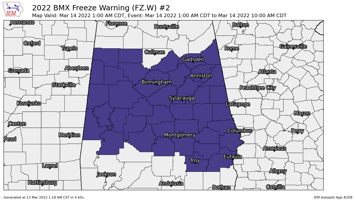
TODAY: After a very chilly start to the day with early morning lows in the upper teens to the mid 20s across the area at sunrise, temperatures will make a nice recovery with plenty of sunshine. Highs will be in the mid to upper 50s. All of Central Alabama will go back under a Freeze Warning tonight as lows will dip into the upper 20s to the lower 30s.
THIS WEEK: Monday will be an even better day, as high pressure will be just off to our east, which will pull warmer air up into the area. Skies will be mostly sunny, with highs in the upper 50s to the upper 60s. However, a few showers will be possible after midnight as a system approaches from the west. A shortwave will be moving through the area on Tuesday that will bring showers and thunderstorms back into the forecast, especially during the afternoon and evening hours. Strong storms will be possible across the Gulf Coast, but severe weather is not likely across Central Alabama at this time. Highs will be in the 60s.
With a surface low riding across the Florida Panhandle, it will keep skies partly cloudy with a small chance of showers on Wednesday before noon. Highs will be in the upper 60s to the lower 70s. Skies will be mostly sunny on Thursday, and it will be a really nice late winter’s day as highs will reach the 70s across the area. However, an approaching system will bring a chance of showers to the forecast during the late night and overnight hours. A cold front will move through the area on Friday that will bring showers and thunderstorms back into Central Alabama during the daylight hours, with much of the activity pushing off into Georgia by the early evening. Severe weather doesn’t look likely at this point as well, but we’ll keep an eye on it as we are in our main severe weather season. Highs will be in the upper 60s to the upper 70s.
NEXT WEEKEND: That system will continue to slowly push through the rest of Central Alabama on Saturday, that will keep showers and thunderstorms in the forecast, especially for the east and southeast. Highs will be in the mid 60s to the mid 70s. Sunday will be a much better day with mostly sunny skies and mild temperatures as highs will reach the upper 60s to the mid 70s.
Category: Alabama's Weather, ALL POSTS, Weather Xtreme Videos, Winter Weather
About the Author (Author Profile)
Scott Martin is an operational meteorologist, professional graphic artist, musician, husband, and father. Not only is Scott a member of the National Weather Association, but he is also the Central Alabama Chapter of the NWA president. Scott is also the co-founder of Racecast Weather, which provides forecasts for many racing series across the USA. He also supplies forecasts for the BassMaster Elite Series events including the BassMaster Classic.Subscribe
If you enjoyed this article, subscribe to receive more just like it.


