Late Morning Weather Check; Strong to Severe Storms Remain Possible on Friday

AT 10 AM: We still have some areas of dense fog out there over portions of North/Central Alabama, but that will continue to lift throughout the remainder of the morning, and we should have mainly sunny skies by midday. Temperatures were in the lower 50s to the mid 60s. Troy was the warm spot at 64º, while the cool spots were Gadsden and Anniston at 52º. Birmingham was at 61º.
WEATHER FOR THE REST OF TODAY: Once all the fog has lifted, we’ll end up with mainly sunny skies through the rest of the morning and afternoon hours. Highs will top out in the lower to mid 70s across the area. Unfortunately, the nice weather will end tonight as clouds will be on the increase, and we can expect showers and thunderstorms over the western half of the area during the overnight hours. Lows will be in the lower to mid 50s.

STRONG TO SEVERE STORMS ON FRIDAY: We’ll have a dynamic system push across the area on Friday that will bring a threat of strong to severe storms to the area, especially south of the I-20 corridor. A Slight Risk for severe storms is up for locations along and south of a line from Greensboro to Calera to Wedowee, while a Marginal Risk is up for the rest of North/Central Alabama. Highs will be in the upper 60s to the upper 70s.
The threat will come in two rounds, with the first round bringing a risk of severe storms to the southern half of the area mainly from 4 am to midday with the threats of damaging winds and a brief tornado. The second round will include all of Central Alabama that will start around 1 pm and come to an end around 10 pm, where once again, damaging winds and a couple tornadoes. The second round will be conditional if the atmosphere can recover from the first round.
THE CENTRAL ALABAMA WEEKEND: We’ll have a rather quiet weekend across Central Alabama, with mostly sunny skies on both days. Highs will be in the upper 50s to the lower 70s across the area on Saturday, and back up into the upper 60s to the lower 70s on Sunday.
NEXT WEEK: Monday will be another quiet day across the area as we’ll stay dry and mild for one last day, before a strong system moves into the area for Tuesday and Wednesday. Highs will be in the 70s.
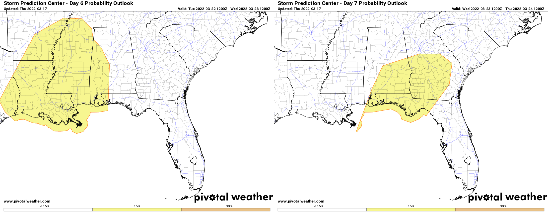
The SPC continues to have much of the western half of the state in a Slight Risk on Tuesday and much of the southern half of the state in a Slight Risk on Wednesday as the system will bring strong to severe storms to the area mainly from late Tuesday through a good portion of Wednesday. For now, it is still too early to know the timing, the threats, and the magnitude. Let’s get through Friday’s system before we start to focus on this event. Tuesday’s highs will be in the mid 70s to the lower 80s, and staying in the 70s for Wednesday.
Temperatures will be a little cooler on Thursday and Friday as quiet and dry weather returns to the area. Highs will be in the mid 60s to the mid 70s on Thursday, then dropping back into the lower 60s to the lower 70s on Friday.
Category: Alabama's Weather, ALL POSTS, Severe Weather
About the Author (Author Profile)
Scott Martin is an operational meteorologist, professional graphic artist, musician, husband, and father. Not only is Scott a member of the National Weather Association, but he is also the Central Alabama Chapter of the NWA president. Scott is also the co-founder of Racecast Weather, which provides forecasts for many racing series across the USA. He also supplies forecasts for the BassMaster Elite Series events including the BassMaster Classic.Subscribe
If you enjoyed this article, subscribe to receive more just like it.


