Severe Thunderstorms Possible Across Alabama Tomorrow
SUNNY MARCH DAY: We have a beautiful afternoon across Alabama… with a sunny sky temperatures are in the low to mid 70s. Clouds will return tonight, however, and tomorrow promises to be an active day with potential for heavy rain and severe thunderstorms.
SPC has upgraded parts of South Alabama to an “enhanced risk” (level 3/5)… this includes places like Mobile, Gulf Shores, Jackson, Atmore, Monroeville, Evergreen, Andalusia, and Geneva. The rest of the state is now in a “slight risk” (level 2/5).

The forecast for tomorrow is somewhat complex, with rain and storms coming in two rounds…
ROUND ONE: The first batch of rain and storms will move through the state in the 6:00 a.m. to 12:00 noon time frame. The primary tornado threat with this activity will come over the “enhanced risk” across South Alabama, where surface based instability will be available. For the rest of the state (North/Central Alabama)… the morning storms will produce heavy rain and gusty winds, but tornadoes are not likely with no instability present (the storms will be elevated and not rooted in the boundary layer).
ROUND TWO: Additional storms (they will be somewhat scattered) will form ahead of the cold front during the afternoon and evening hours, generally between 2:00 and 9:00 p.m. It looks like the air can recover sufficiently for a decent degree of surface based instability, and with high shear values these storms will be capable of producing large hail, damaging winds, and a few tornadoes across the northern 2/3 of the state.
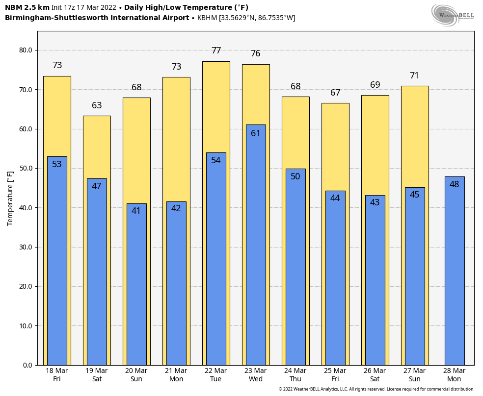
Bottom line… tomorrow will be an active day statewide, and you need to be in a position to hear severe weather watches and warnings. The high tomorrow afternoon will be in the mid 70s in most places; some sun is possible between the two rounds of storms.
THE WEEKEND: Dry air returns, and we are forecasting sunny pleasant days and clear chilly nights over the weekend. The high Saturday will be in the mid 60s, followed by low 70s Sunday. Colder spots will be in the 30s early Sunday with potential for a little scattered light frost.
NEXT WEEK: Monday will be dry and mild, then another vigorous weather system will bring more thunderstorms to the state Tuesday night into part of the day Wednesday, and those storms could be severe (SPC has much of the state in severe weather risks in their Day 6/7 outlooks). It is too early to know the magnitude associated with this event… once we get past tomorrow we will be much more specific about the threats and the timing. Thursday and Friday of next week look dry and pleasant; See the Weather Xtreme video for maps, graphics, and more details.
ON THIS DATE IN 1990: Showers and thunderstorms associated with a slow-moving cold front produced torrential rains across parts of the southeastern U.S. over two days. Flooding claimed the lives of at least 22 persons, including thirteen in Alabama. Up to 16 inches of rain deluged southern Alabama with 10.63 inches reported at Mobile in 24 hours. The town of Elba was flooded with 6 to 12 feet of water causing more than 25 million dollars damage, and total flood damage across Alabama exceeded 100 million dollars. Twenty-six counties in the state were declared disaster areas.
ON THIS DATE IN 2021: A total of 25 tornadoes touched down in Alabama; this included 3 rated EF-2. The longest-track tornado was 36.5 miles, associated with a tornado from Wayne County, Mississippi to southern Marengo County, Alabama. There were no fatalities; two were injured in an EF-2 tornado at Burnsville in Dallas County (near Selma), and there was one minor injury in an EF-0 tornado north of Birmingham near Mount Olive.
BEACH FORECAST: Click here to see the AlabamaWx Beach Forecast Center page.
WEATHER BRAINS: Don’t forget you can listen to our weekly 90 minute show anytime on your favorite podcast app. This is the show all about weather featuring many familiar voices, including our meteorologists here at ABC 33/40.
CONNECT: You can find me on all of the major social networks…
Look for the next Weather Xtreme video here by 6:00 a.m. tomorrow…
Category: Alabama's Weather, ALL POSTS, Weather Xtreme Videos
About the Author (Author Profile)
James Spann is one of the most recognized and trusted television meteorologists in the industry. He holds the AMS CCM designation and television seals from the AMS and NWA. He is a past winner of the Broadcast Meteorologist of the Year from both professional organizations.Subscribe
If you enjoyed this article, subscribe to receive more just like it.


