Tornado Watch Coming Shortly for Western & Northwest Portions of the Area
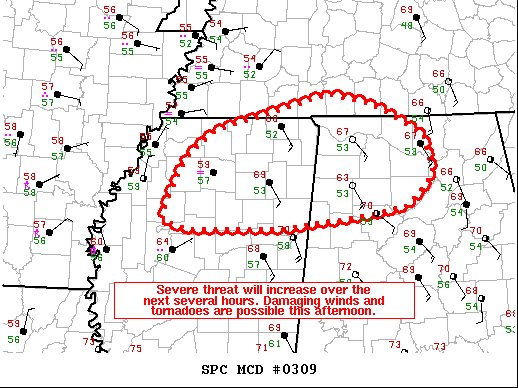
The Storm Prediction Center is highly considering issuing a Tornado Watch for the northern and northwestern parts of the area very shortly, possibly within the next 30-60 minutes. Here is the latest Mesoscale Discussion from the SPC:
Probability of Watch Issuance…80 percent
SUMMARY… Some increase in potential for damaging winds and QLCS tornadoes is expected through the afternoon. A watch will likely be considered in the next hour.
DISCUSSION… Filtered sunshine through upper-level clouds has warmed temperatures into the upper 60s F across northern Mississippi/Alabama. More importantly, dewpoints which began the day in the 40s F have now risen into the low 50s F as the warm front has continued to the north. Given the current northeastward speed of the ongoing convection in western Mississippi, continued destabilization should support on the order of 500-1000 J/kg MLCAPE by mid/late afternoon. Greater uncertainty in sufficient destabilization exist in north-central into northwest Mississippi. A favorably timed increase in the 850-700 mb winds will bring an attendant threat of damaging wind gusts and QLCS-embedded circulations/tornadoes.
Category: Alabama's Weather, ALL POSTS, Severe Weather
About the Author (Author Profile)
Scott Martin is an operational meteorologist, professional graphic artist, musician, husband, and father. Not only is Scott a member of the National Weather Association, but he is also the Central Alabama Chapter of the NWA president. Scott is also the co-founder of Racecast Weather, which provides forecasts for many racing series across the USA. He also supplies forecasts for the BassMaster Elite Series events including the BassMaster Classic.Subscribe
If you enjoyed this article, subscribe to receive more just like it.


