Midday Nowcast: Severe Storms on the Way
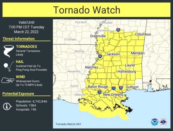
A very dynamic storm system is impacting the Deep South today as a severe weather outbreak is likely. These severe storms and the threat of flooding highlight the forecast for the rest of today and into the overnight hours. Late this morning, we are already have a Tornado Watch in effect for much of Mississippi. As the storms move east, watches will eventually be needed in Alabama.
First, gradient winds (not related to thunderstorms) could gust as high as 35/40 mph across the state this afternoon and overnight and is why a wind advisory is in effect for almost all of Alabama. These winds could bring a few scattered power outages…Now for the storm threat:
PLACEMENT: SPC has maintains the “moderate risk” (level 4/5) into far Southwest Alabama, including parts of Sumter, Choctaw, Clarke, and Washington counties. An “enhanced risk” (level 3/5) extends as far east as Carbon Hill, Brookwood, Marion, Camden, and Monroeville. A “slight risk” (level 2/5) is defined over to Huntsville, Pell City, Union Springs and Ozark, and the rest of North and East Alabama is in a “marginal risk” (level 1/5).
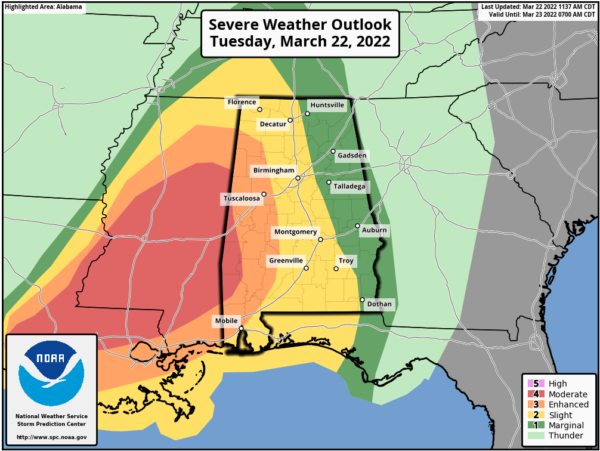
TIMING: Over West Alabama this afternoon, a few discrete cells could form ahead of the main line. This is where there is the best combination of shear and instability; these will feature the highest tornado potential. Instability values are not especially high for mid-March in Alabama, but certainly sufficient for strong to severe storms. Instability over East Alabama will be very limited tonight. The main activity, will begin to enter West Alabama by 2PM, and will continue to push east towards the Interstate 65 corridor during the evening hours and overnight hours, 5-10PM, and then over the eastern third of the state after 11:00PM. For Southeast Alabama, it will be during the early morning hours Wednesday.
THREATS: This is a more typical spring-time severe weather event for Alabama so all modes (types) of severe weather are possible. Storms will be capable of producing large hail, damaging winds (up to 70 mph), and tornadoes. The highest tornado potential is in the “moderate” and “enhanced” risk areas across West and Southwest Alabama this afternoon into the evening hours, where a strong tornado (EF-2 or higher) will be possible. The main threat will shift to strong winds tonight as the activity rolls into a long squall line (QLCS).
FLOODING: Rain amounts of 2-4″ are likely over the western half of the state, with 1-2″ for the eastern counties. A flood watch is in effect for much of Central, West, and North Alabama.
CALL TO ACTION: Be prepared and make sure you have all aspects of your severe weather safety plan ready for action. Be sure you have a way of hearing severe weather warnings, and an action plan if you are in a tornado warning polygon, take severe thunderstorm warnings seriously too. Have a NOAA Weather Radio in your home and business, properly programmed with a fresh battery in case of power failure. Be sure WEA (Wireless Emergency Alerts) enabled on your phone… this is not an app, but built into every phone sold in the U.S. Check settings, and notifications, and be sure emergency alerts are on. Have the free ABC 33/40 weather app on your phone as a secondary way of getting warnings. Search the App Store for “ABC 33/40 Weather” if you don’t have it already.
In a site built home, identify the safe place. Small room, lowest floor, near the center of the house, away from windows. And, in that safe place, have helmets for everyone in the family (including adults!), portable air horns, and hard sole shoes. You CANNOT stay in a mobile home if you are in a tornado warning polygon. Know the closest shelter, and how to get there quickly. Also, be a hero, let people know about the weather, and that it could impact them
WATCH: If tornado warnings are issued, watch us on ABC 33/40. Remember, local TV is free, over the air. You don’t need cable, satellite, or an Internet connection. To watch online, the best options are…
YouTube: http://youtube.com/abc3340?
Facebook: http://facebook.com/abc3340
REMEMBER: Don’t be anxious or worried; events like this are very common in Alabama during our tornado season, especially March and April. Have a way of hearing warnings, have a plan, and you will be fine. Odds of any one spot being hit by a tornado are low, but we all have to be ready.
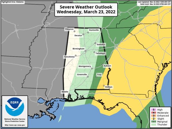
TOMORROW: Strong to severe storms could linger into tomorrow morning over the Southeast Alabama, where SPC has a “slight risk” (level 2/5) defined. This is for early tomorrow, before 10AM as some strong storms with damaging winds are likely, although an isolated tornado can’t be ruled out. For the rest of the state, clouds will linger through much of the day with a high in the 67-70 degree range.
QUIET THROUGH WEEKEND: For the rest of the week and through the weekend, expect dry days with more sun than clouds. It will bd cooler Thursday and Friday with highs in the low to mid 60s. For Saturday and Sunday, expect lots of sunshine with highs continuing to be in the low to mid 60s. Mornings will be chilly with 30s and 40s fairly common.
NEXT WEEK: Monday will be dry and warmer with a high in the 70s. A few showers are possible over far North Alabama Tuesday, but the next signifiant rain event will likely come by Thursday when thunderstorms return; too early to know if this will feature a severe weather threat.
BEACH FORECAST CENTER: Get the latest weather and rip current forecasts for the beaches from Fort Morgan to Panama City on our Beach Forecast Center page. There, you can select the forecast of the region that you are interested in visiting.
WORLD TEMPERATURE EXTREMES: Over the last 24 hours, the highest observation outside the U.S. was 113.0F at Goure, Niger. The lowest observation was -83.0F at Amundsen-Scott South Pole Station, Antarctica.
CONTIGUOUS TEMPERATURE EXTREMES: Over the last 24 hours, the highest observation was 99F at Falcon Lake, TX. The lowest observation was -17F at Peter Sinks, UT.
Category: Alabama's Weather, ALL POSTS, Severe Weather
About the Author (Author Profile)
Macon, Georgia Television Chief Meteorologist, Birmingham native, and long time Contributor on AlabamaWX. Stormchaser. I did not choose Weather, it chose Me. College Football Fanatic. @Ryan_StinnetSubscribe
If you enjoyed this article, subscribe to receive more just like it.


