Latest Mesoscale Discussion — Severe Threat Continues Across Tornado Watch Locations
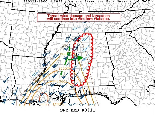
SUMMARY… Some threat for damaging wind gusts and QLCS tornadoes will continue into western Alabama this afternoon. The threat will generally be greater in west-central Alabama where moisture/buoyancy is greater.
DISCUSSION… Storms within central/eastern Mississippi have largely remained linear this afternoon. There are some discrete cells ahead of the primary line. The most substantial of these discrete storms is moving northeast through Kemper County, MS and has recently shown a TDS on KDGX radar. The overall expectation is for these cells to be overtaken by the line in the next 60-90 minutes. Going forward, wind damage and QLCS tornadoes are expected to be the primary threats as convection moves into western Alabama. The environment ahead of the convective line has been able to warm to near 80 F in several places. However, moisture return in Alabama has been much less than in Mississippi. Consequently, MLCAPE values have remained from 300-400 J/kg in northern Alabama to 500-700 in west-central Alabama. Due to the forward speed of the line, it is uncertain how much further destabilization can occur through the afternoon. In any event, some potential for damaging wind gusts and QLCS tornadoes will exist given the strong low-level winds and low-level hodograph turning observed in region VWPs.
Category: ALL POSTS
About the Author (Author Profile)
Scott Martin is an operational meteorologist, professional graphic artist, musician, husband, and father. Not only is Scott a member of the National Weather Association, but he is also the Central Alabama Chapter of the NWA president. Scott is also the co-founder of Racecast Weather, which provides forecasts for many racing series across the USA. He also supplies forecasts for the BassMaster Elite Series events including the BassMaster Classic.Subscribe
If you enjoyed this article, subscribe to receive more just like it.


