Latest Mesoscale Discussion — New Tornado Watch Possible for Southern Portions of the Area
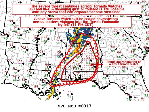
SUMMARY… The severe threat across Tornado Watches 063 and 064 continues. A damaging gust or a tornado remains possible over the next few hours. A downstream Tornado Watch will be needed by 04Z.
DISCUSSION… A QLCS continues to meander eastward across central Alabama, with a few semi-discrete, transient supercells ongoing along the Gulf Coastal area. These storms are progressing eastward in an impressively sheared environment, but with gradually waning instability. The area 88-D VADs depict large, curved hodographs, with 300-600 m2/s2 0-1km SRH. While surface temperatures have been cooling into the upper 60s/low 70s F, increasing surface dewpoints may offset temperature-related buoyancy decreases given a continued northward moisture flux.
Nonetheless, given the intense low-level shear and modest deep-layer ascent present, any storm that manages to organize may produce a damaging gust or a tornado. The best chance for a damaging gust would be with the central AL QLCS, with a tornado equally likely embedded within this QLCS, or with any supercell that can sustain low-level rotation from central AL to the Gulf Coast. A downstream Tornado Watch will be needed by 04Z across southern/eastern Alabama into the Western Florida Panhandle to address the continuing severe threat.
Category: Alabama's Weather, ALL POSTS, Severe Weather
About the Author (Author Profile)
Scott Martin is an operational meteorologist, professional graphic artist, musician, husband, and father. Not only is Scott a member of the National Weather Association, but he is also the Central Alabama Chapter of the NWA president. Scott is also the co-founder of Racecast Weather, which provides forecasts for many racing series across the USA. He also supplies forecasts for the BassMaster Elite Series events including the BassMaster Classic.Subscribe
If you enjoyed this article, subscribe to receive more just like it.


